Tokashiki, Okinawa
| Tokashiki 渡嘉敷村 | |
|---|---|
| Village | |
 Location of Tokashiki in Okinawa Prefecture | |
 Tokashiki Location in Japan | |
| Coordinates: 26°12′0″N 127°22′0″E / 26.20000°N 127.36667°ECoordinates: 26°12′0″N 127°22′0″E / 26.20000°N 127.36667°E | |
| Country | Japan |
| Region | Kyushu |
| Prefecture | Okinawa Prefecture |
| District | Shimajiri |
| Government | |
| • Mayor | Masashige Zamami |
| Area | |
| • Total | 19.18 km2 (7.41 sq mi) |
| Population (March 31, 2013) | |
| • Total | 697 |
| • Density | 36/km2 (94/sq mi) |
| Symbols | |
| • Tree | Chinese Fan Palm |
| • Flower | Kerama Azalea |
| • Fish | Skipjack tuna |
| Time zone | Japan Standard Time (UTC+9) |
| City hall address |
183 Tokashiki, Tokashiki-son, Shimajiri-gun, Okinawa 901-3592 |
| Website |
www |
Tokashiki (渡嘉敷村 Tokashiki-son) is a village located in the Kerama Islands in Okinawa Prefecture, Japan. It includes 10 islands, of which only two, Tokashiki and Maejima are inhabited. The village is part of Shimajiri District.[1] Tokashiki is known for its corals, sea, beach and sun. From Tomari Port in Naha, it takes less than one hour to reach this island.
On 28 March 1945, during Second World War, 394 inhabitants, mostly from farmer families, immolated themselves with grenades after the landing of US troops.[2]
Geography
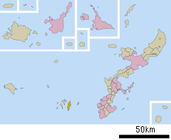
The village of Tokashiki consists of 10 islands of various sizes in the center of the Kerama Islands. The village is located approximately 30 kilometres (19 mi) west of Naha, the prefectural capital of Okinawa. The islands of village, notably Tokashiki Island, are rugged and mountainous.[1]
History
Early history
Prior to World War II Tokashiki produced charcoal for the city of Naha. Bonito fishing was also a mainstay of the population of the island, but as the bonito industry declined, the population of the village was reduced greatly.
World War II
The American forces landed on Tokashiki on March 27, 1945 as an early part of the Battle of Okinawa. On the following day, March 28, 1945, 394 inhabitants of Tokashiki, mostly from farming families, immolated themselves with grenades after the landing of US troops in a practice that became known as shūdan jikketsu, or group suicide. The group suicide on Tokashiki in late March was a precursor to large-scale group suicides on Okinawa Island in the following months.[2]
Transportation
Tokashiki Island is connected to Tomari Port in Naha by ferry.[1]
Economy
Agriculture
Tokashiki is home to small-scale farming. A small amount of vegetables are produced in the village.[1]
Tourism
The village of Tokashiki is part of Okinawa Kaigan Quasi-National Park and is blessed with a remarkable number of spots of scenic beauty. Due to this, the village has promoted tourism as a primary industry since the reversion of Okinawa Prefecture to Japan in 1972. Numerous tourist facilities such as hotels, esplanades, and viewing towers have been built across Tokashiki Island.[1]
Noted places
- Shinrin Park. The park is accessible from the Aharen district only by foot, and consist of a wide grassy area and a large-scale wooden for children. Shinrin Park is quiet as it has relatively few visitors.[3]
References
- 1 2 3 4 5 "渡嘉敷(村)" [Tokashiki]. Nihon Daihyakka Zensho (Nipponika) (in Japanese). Tokyo: Shogakukan. 2013. OCLC 153301537. Retrieved 2013-05-02.
- 1 2 Hastings, Max (2007). Nemesis: the battle for Japan, 1944-45. London: HarperPress. p. 372. ISBN 9780007219827. OCLC 148289737.
- ↑ 渡嘉敷島 [Tokashiki Island] (in Japanese). Naha, Okinawa Prefecture, Japan: Okinawa Information IMA. 2011. Retrieved 2013-05-21.
External links
 Media related to Tokashiki, Okinawa at Wikimedia Commons