Tonaki, Okinawa
| Tonaki 渡名喜村 Tunachi | |
|---|---|
| Village | |
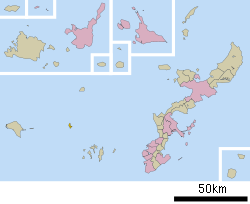 Location of Tonaki in Okinawa Prefecture | |
 Tonaki Location in Japan | |
| Coordinates: 26°22′20″N 127°08′28″E / 26.37222°N 127.14111°ECoordinates: 26°22′20″N 127°08′28″E / 26.37222°N 127.14111°E | |
| Country | Japan |
| Region | Kyushu |
| Prefecture | Okinawa Prefecture |
| District | Shimajiri |
| Area | |
| • Total | 3.74 km2 (1.44 sq mi) |
| Population (2013) | |
| • Total | 406 |
| • Density | 110/km2 (280/sq mi) |
| Time zone | Japan Standard Time (UTC+9) |
| Website |
www |
Tonaki (渡名喜村 Tonaki-son, Okinawan: Tunachi) is a village located in Shimajiri District, Okinawa Prefecture, Japan. The village consists of Tonaki Island and the uninhabited Irisuna Island.[1]
As of 2013, the village has an estimated population of 406 and a density of 110 persons per km². The total area is 3.74 square kilometres (1.44 sq mi). The highest point in Tonaki is on Tonaki Island at 178.4 metres (585 ft)[2][3]
Tonaki is located approximately 58 kilometres (36 mi) northwest of the prefectural capitol of Naha. The village is accessible by regular ferry service from Tomari Port in Naha.[1]
Tonaki was once an active center of bonito fishing, but now the village economy is evenly divided between agriculture and fishing. Tonaki is in a long-term state of population decline.[3]
See also
References
- 1 2 "渡名喜(村)" [Tonaki Village]. Nihon Daihyakka Zensho (Nipponika) (in Japanese). Tokyo: Shogakukan. 2013. OCLC 153301537. Retrieved 2013-08-02.
- ↑ 渡名喜村の人口と世帯 [Population and Households of the Village of Tonaki] (in Japanese). Tonaki, Okinawa Prefecture, Japan: Village of Tonaki. 2013. Retrieved 2013-08-02.
- 1 2 "渡名喜島" [Tonaki Island]. Nihon Rekishi Chimei Taikei (in Japanese). Tokyo: Shogakukan. 2013. OCLC 173191044. Retrieved 2013-08-02.
External links
 Media related to Tonaki, Okinawa at Wikimedia Commons
- Tonaki-son official website (Japanese)
- Tonaki-son Elementary and Junior High School (Japanese)