Kin, Okinawa
| Kin 金武町 | |
|---|---|
| Town | |
|
Kin Town Office | |
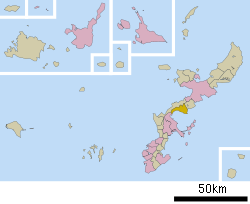 Location of Kin in Okinawa Prefecture | |
 Kin Location in Japan | |
| Coordinates: 26°27′22″N 127°55′34″E / 26.45611°N 127.92611°ECoordinates: 26°27′22″N 127°55′34″E / 26.45611°N 127.92611°E | |
| Country | Japan |
| Region | Kyushu |
| Prefecture | Okinawa Prefecture |
| District | Kunigami |
| Area | |
| • Total | 37.57 km2 (14.51 sq mi) |
| Population (December, 2012) | |
| • Total | 11,390 |
| • Density | 300/km2 (790/sq mi) |
| Symbols | |
| • Tree | Chinese fan palm |
| • Flower | Sakura |
| Time zone | Japan Standard Time (UTC+9) |
| City hall address |
1 Aza Kin, Kin-cho, Kunigami-gun 904-1292 |
| Website |
www |

Kin (金武町 Kin-chō, Kunigami & Okinawan: Chin) is a town located in Kunigami District, Okinawa Prefecture, Japan.
In 2012, the town had an estimated population of 11,390 and a density of 300 persons per km2.[1] The total area of Kin is 37.57 square kilometres (14.51 sq mi). 59% of the land area of Kin remains under control of the United States military, the highest percentage of any municipality in Okinawa Prefecture.[2] The population of the town is concentrated on a strip of land on the coast of Kin Bay. Kin is home to Camp Hansen, a military base of the United States Marines, as well as other smaller military installations.[3]
Kin is home to the Dragon Brand of awamori, with a beautiful Buddhist shrine built in 1522, and a 270-meter natural cave known as Kin Shonyudo that doubles as both a place of worship and a cellar for aging bottles of the drink. Kin is also claimed to be the origin of taco rice, a dish emblematic of modern Okinawan cuisine.[4][5]
Geography
Kin is located at the middle of Okinawa Island, and is roughly triangular in shape. The town is roughly 13 kilometres (8.1 mi) long from east to west. From north to south the town ranges between 2 kilometres (1.2 mi) to 8 kilometres (5.0 mi) at its widest point, measured from Būtodake in Camp Hansen to the tip of Cape Kin.[6]
Neighboring municipalities
Districts
Kin is divided into five districts.
- Kin (金武区 Kin-ku) serves as the central business and administrative district of the town. 50% of the population of the town lives in the district. The main gate of Camp Hansen is located in the Kin district, and consequently, businesses that cater to the population of the base are located within the district.
- Namizato (並里区 Namizato-ku), along with Kin district, forms the most populated parts of the town.
- Nakagawa (中川区 Nakagawa-ku) is the northernmost district in the city, and borders the village of Ginoza. Nakagawa is the most agricultural part of Kin.
- Igei (伊芸区 Igei-ku) is largely base land. 80% of the district is used by the United States military; the remainder of the land is agricultural, and is used for rice production.
- Yaka (屋嘉区 Yaka-ku) sits in the south of Kin on the border of the city of Uruma. Some of the hilly areas of Yaka have been developed for agriculture.[6]
Government
Kin is governed from the Kin Town Office in the central district of the town, also known as Kin. The municipal Board of Education oversees the middle school, three elementary schools, three nursery school, and other community facilities in the town. The Kin Municipal Assembly consists of 16 members who serve a four-year term, and are led by a chairperson and vice-chairperson.[7]
The Okinawa Prefecture Police provides law enforcement for Kin; the town has no municipal police service. The Ishikawa Police Station, located in nearby Uruma, covers Kin, as well as the town of Onna, Ginoza, and the Ishikawa area of Uruma.[8]
Noted places

Kin is home to the Kin Kannon-ji, a Buddhist temple that traces its history to the 16th century. By tradition the temple was constructed by Nisshō Shōnin, a resident of Ise who was attempting to travel to China. Nisshō Shōnin was shipwrecked in the Ryukyu Islands, and took refuge at the small port of Funaya in Kin. There he founded the temple. The hondō main hall of the temple was reconstructed in 1942. Unlike most structures in southern Okinawa Island, it was not destroyed in the Battle of Okinawa. The wooden structure is designated an important cultural property by the Town of Kin. The temple additionally serves as a site for the display of traditional handicrafts, festivals, and performances.[9][10]
United States military bases
Kin is home to Camp Hansen (51.4 square kilometres (19.8 sq mi)), a U.S. Marine Corps base that supports ground combat, communications, 31st MEU(SOC), 7th Communication Battalion, 9th Engineer Support Battalion, 12th Marine Regiment, 3d MEF Headquarters Group, 3 MEF Special Operations Training Group Small Craft Raid Platoon and other battle elements. Historically, Kin is known as an entertainment location for the U.S. Marines stationed there.
Although there have been recent military backlashes in Okinawa, Kin is very welcoming to the military, as they receive income for such things as port use, tourism, and merchants. After the terrorist attacks of 9/11, Marines from U.S. 3d Marine Division were able to leave directly out of the ports in Kin via HSV Ferry to deploy to other areas in the Far East rather than flying.
References
- ↑ 人口・世帯数 [Populations, Households] (in Japanese). Kin, Okinawa Prefecture, Japan: Town of Kin. 2012. Retrieved Dec 27, 2013.
- ↑ "金武(町)" [Kin]. Nihon Rekishi Chimei Taikei (in Japanese). Tokyo: Shogakukan. 2013. OCLC 173191044. dlc 2009238904. Retrieved 2013-04-10.
- ↑ "金武(町)". Encyclopedia of Japan. Tokyo: Shogakukan. 2013. OCLC 56431036. Retrieved 2013-04-10.
- ↑ "This Japanese Dish Exists Only Because Of The US Military". We Are The Mighty. 17 March 2015. Archived from the original on 19 May 2015. Retrieved 19 May 2015.
- ↑ Oscar Johnson and Elena Sugiyama (28 March 2015), "A TRIBUTE TO TACO RICE: The U.S. military's favorite Mex-Oki fusion food", Stars and Stripes Okinawa, archived from the original on 19 May 2015, retrieved 19 May 2015
- 1 2 金武町の地図・交通 [Map, Transportation in Kin] (in Japanese). Kin, Okinawa Prefecture, Japan: Town of Kin. 2006. Retrieved 2013-04-10.
- ↑ 金武町議会 [Kin Municipal Council] (in Japanese). Kin, Okinawa Prefecture, Japan: Town of Kin. 2013. Retrieved 2013-04-10.
- ↑ 石川警察署 [Ishikawa Police Station] (in Japanese). Naha, Okinawa Prefecture, Japan: Okinawa Prefecture Police. 2013. Retrieved 2013-04-10.
- ↑ 観音寺 [建設物] ["Building" of Kannon-ji] (in Japanese). Kin, Okinawa Prefecture, Japan: Kin Kannon-ji. 2006. Retrieved 2013-05-28.
- ↑ 金武観音寺鍾乳洞 [The Limestone Cave of Kin Kannon-ji] (in Japanese). Naha, Okinawa Prefecture, Japan: Okinawa Convention & Visitors Bureau. 2013. Retrieved 2013-05-28.
| Wikimedia Commons has media related to Kin, Okinawa. |