Jackson Township, Vinton County, Ohio
| Jackson Township, Vinton County, Ohio | |
|---|---|
| Township | |
|
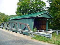
Mt. Olive Road Covered Bridge, a historic site in the township | |
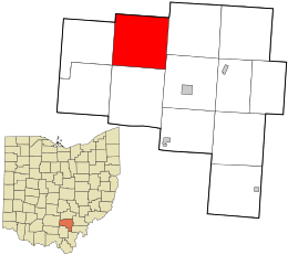 Location in Vinton County and the state of Ohio. | |
| Coordinates: 39°19′23″N 82°35′0″W / 39.32306°N 82.58333°WCoordinates: 39°19′23″N 82°35′0″W / 39.32306°N 82.58333°W | |
| Country | United States |
| State | Ohio |
| County | Vinton |
| Area | |
| • Total | 37.5 sq mi (97.2 km2) |
| • Land | 37.5 sq mi (97.2 km2) |
| • Water | 0.0 sq mi (0.0 km2) |
| Elevation[1] | 883 ft (269 m) |
| Population (2000) | |
| • Total | 714 |
| • Density | 19.0/sq mi (7.3/km2) |
| Time zone | Eastern (EST) (UTC-5) |
| • Summer (DST) | EDT (UTC-4) |
| FIPS code | 39-38136[2] |
| GNIS feature ID | 1087104[1] |
Jackson Township is one of the twelve townships of Vinton County, Ohio, United States. The 2000 census found 714 people in the township.[3]
Geography
Located in the northern part of the county, it borders the following townships:
- Benton Township, Hocking County: north
- Swan Township: east
- Elk Township: southeast
- Richland Township: south
- Harrison Township: southwest corner
- Eagle Township: west
- Salt Creek Township, Hocking County: northwest
No municipalities are located in Jackson Township, but it does contain the unincorporated community of Stella.
Name and history
Jackson Township was organized in 1831.[4]
It is one of thirty-seven Jackson Townships statewide.[5]
Government
The township is governed by a three-member board of trustees, who are elected in November of odd-numbered years to a four-year term beginning on the following January 1. Two are elected in the year after the presidential election and one is elected in the year before it. There is also an elected township fiscal officer,[6] who serves a four-year term beginning on April 1 of the year after the election, which is held in November of the year before the presidential election. Vacancies in the fiscal officership or on the board of trustees are filled by the remaining trustees.
References
- 1 2 "US Board on Geographic Names". United States Geological Survey. 2007-10-25. Retrieved 2008-01-31.
- ↑ "American FactFinder". United States Census Bureau. Archived from the original on September 11, 2013. Retrieved 2008-01-31.
- ↑ Vinton County, Ohio — Population by Places Estimates Ohio State University, 2007. Accessed 16 May 2007.
- ↑ History of Hocking Valley, Ohio. Inter-State Publishing Co. 1883. p. 1309.
- ↑ "Detailed map of Ohio" (PDF). United States Census Bureau. 2000. Retrieved 2007-02-16.
- ↑ §503.24, §505.01, and §507.01 of the Ohio Revised Code. Accessed 4/30/2009.
External links
Municipalities and communities of Vinton County, Ohio, United States | ||
|---|---|---|
| Villages |  | |
| Townships | ||
| Unincorporated communities | ||
| Ghost towns | ||