Knox Township, Vinton County, Ohio
| Knox Township, Vinton County, Ohio | |
|---|---|
| Township | |
|
Harkins Chapel | |
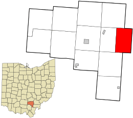 Location in Vinton County and the state of Ohio. | |
| Coordinates: 39°14′49″N 82°18′2″W / 39.24694°N 82.30056°WCoordinates: 39°14′49″N 82°18′2″W / 39.24694°N 82.30056°W | |
| Country | United States |
| State | Ohio |
| County | Vinton |
| Area | |
| • Total | 25.1 sq mi (64.9 km2) |
| • Land | 25.1 sq mi (64.9 km2) |
| • Water | 0.0 sq mi (0.0 km2) |
| Elevation[1] | 804 ft (245 m) |
| Population (2000) | |
| • Total | 599 |
| • Density | 23.9/sq mi (9.2/km2) |
| Time zone | Eastern (EST) (UTC-5) |
| • Summer (DST) | EDT (UTC-4) |
| FIPS code | 39-40880[2] |
| GNIS feature ID | 1087105[1] |

Knox Township is one of the twelve townships of Vinton County, Ohio, United States. The 2000 census found 599 people in the township.[3]
Geography
Located in the far eastern part of the county, it borders the following townships:
- Waterloo Township, Athens County: northeast
- Lee Township, Athens County: east
- Columbiana Township, Meigs County: southeast
- Vinton Township: southwest
- Madison Township: west
- Brown Township: northwest
No municipalities are located in Knox Township.
Name and history
Knox Township was organized in 1850. It was named for General Henry Knox.[4]
It is one of five Knox Townships statewide.[5]
Government
The township is governed by a three-member board of trustees, who are elected in November of odd-numbered years to a four-year term beginning on the following January 1. Two are elected in the year after the presidential election and one is elected in the year before it. There is also an elected township fiscal officer,[6] who serves a four-year term beginning on April 1 of the year after the election, which is held in November of the year before the presidential election. Vacancies in the fiscal officership or on the board of trustees are filled by the remaining trustees.
References
- 1 2 "US Board on Geographic Names". United States Geological Survey. 2007-10-25. Retrieved 2008-01-31.
- ↑ "American FactFinder". United States Census Bureau. Retrieved 2008-01-31.
- ↑ Vinton County, Ohio — Population by Places Estimates Ohio State University, 2007. Accessed 16 May 2007.
- ↑ History of Hocking Valley, Ohio. Inter-State Publishing Co. 1883. pp. 1286–1287.
- ↑ "Detailed map of Ohio" (PDF). United States Census Bureau. 2000. Retrieved 2007-02-16.
- ↑ §503.24, §505.01, and §507.01 of the Ohio Revised Code. Accessed 4/30/2009.
External links
Municipalities and communities of Vinton County, Ohio, United States | ||
|---|---|---|
| Villages | 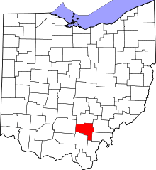 | |
| Townships | ||
| Unincorporated communities | ||
| Ghost towns | ||