Jagatdal
| Jagatdal জগদ্দল Jagaddal | |
|---|---|
| Town | |
| Nickname(s): জগদ্দল | |
 Jagatdal Location in West Bengal, India | |
| Coordinates: 22°51′N 88°23′E / 22.85°N 88.38°ECoordinates: 22°51′N 88°23′E / 22.85°N 88.38°E | |
| Country |
|
| State | West Bengal |
| District | North 24 Parganas |
| Elevation | 15 m (49 ft) |
| Languages | |
| • Official | Bengali, English, Hindi |
| Time zone | IST (UTC+5:30) |
| Lok Sabha constituency | Barrackpore |
| Vidhan Sabha constituency | Jagatdal |
| Website |
north24parganas |
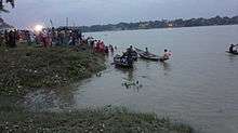
Jagatdal is a town and police station under Barrackpore subdivision[1] in North 24 Parganas district, on the banks of the Ganges river in the state of West Bengal, India. Situated on the eastern banks of the river, the town has many jute mills. The town is administratively part of Bhatpara Municipality. The town has an Indian Army base workshop (No-507).
History
We can find the name of jagaddal as a village as long as 460 years ago in written records but the place is thought to be more 100 to 150 years older or maybe even much more than that. Bipradas Pipalai (1545 AD) in his work "Manasha Mangal" tells us through his protagonist character "Chand Sadagar" about Jagatdal.
"Chand Saudagar mentions in his "Kabi Kankan Chandi", Jagaddal as one of the places passed by him in his voyage down the Bhagirathi (the Hooghly) and where he saw many palatial buildings built by Brahmins and Kayasthas. Haldars were the most prominent Brahmins the others being Chakrabarties and Pakrasis.. Deys were the most renowned Kayastha family."
Pratapaditya (1561–1611 CE),The kayastha king and zamindar of Jessore made a couple of trenches and a fort at Jagatdal alongwith Mulajore,present day Shyamnagar as his military establishment against Muslim invaders.
According to Bengal District Gazetteers: 24-Parganas ,circa 1914
"In Jagatdal the lines of two moats and two large tanks are reputed to be the remains of a fort erected by Pratapaditya in the sixteenth century".
Jagaddal was a village in between Mulajore and Bhatpara of veda-educated, high in culture bengali people before industrialization by East India Co.
Geography
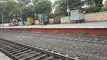
Jagatdal is located at 22°51′N 88°23′E / 22.85°N 88.38°E.[2] It has an average elevation of 15 metres (49 feet). It is 34 km from Sealdah Station and 4 km from Naihati Junction on the Sealdah-Naihati branch line of Eastern Railway.[3] It is part of the Kolkata Suburban Railway system.
Demographics
The Jute Mills drew in a large labour force from the neighbouring states of Bihar and Orissa, as well as eastern Uttar Pradesh, quite often forming an overwhelming majority of the population in the area, living in shanty towns and bustees dotting the mill area.[4] Jagadal chasma-i-rahmat high school is a major educational institution in the area and it serves as the only school in jagatdal where science is taught.
Healthcare
North 24 Parganas district has been identified as one of the areas where ground water is affected by arsenic contamination.[5]
References
- ↑ District-wise list of statutory towns
- ↑ Falling Rain Genomics, Inc - Jagatdal
- ↑ Eastern Railway time table.
- ↑ Goswami, Onkar, Calcutta’s Economy 1918-1970 The fall from Grace in Calcutta, the Living City, Vol II, edited by Sukanta Chaudhuri, p 90, Oxford University Press, ISBN 0-19-563697-X
- ↑ "Groundwater Arsenic contamination in West Bengal-India (19 years study )". Groundwater arsenic contamination status of North 24-Parganas district, one of the nine arsenic affected districts of West Bengal-India. SOES. Retrieved 2007-08-24.
External links
 Kolkata/Northern fringes travel guide from Wikivoyage
Cities, towns and locations in North 24 Parganas district | |
|---|---|
| Cities, municipal and census towns | |
| Locations other than cities and towns | |
| Related topics |
|