Jatun Wasi
For the mountain in Peru, see Hatun Wasi.
| Jatun Wasi | |
|---|---|
 Jatun Wasi | |
| Highest point | |
| Elevation | 4,361 m (14,308 ft) [1] |
| Coordinates | 20°51′45″S 66°03′31″W / 20.86250°S 66.05861°WCoordinates: 20°51′45″S 66°03′31″W / 20.86250°S 66.05861°W |
| Geography | |
| Location |
Bolivia Potosí Department |
| Parent range | Andes |
Jatun Wasi (Quechua jatun, hatun big, wasi house,[2] "big house", also spelled Jatun Huasi) is a 4,361-metre-high (14,308 ft) mountain in the Andes of Bolivia. It is located in the Potosí Department, Nor Chichas Province, Cotagaita Municipality. Jatun Wasi lies at the Agua Castilla River, east of Yaritayuq.[1][3]
References
- 1 2 Bolivian IGM map 1:50,000 Atocha 6331-II
- ↑ Teofilo Laime Ajacopa, Diccionario Bilingüe Iskay simipi yuyayk'ancha, La Paz, 2007 (Quechua-Spanish dictionary)
- ↑ "Cotagaita". INE, Bolivia. Retrieved March 3, 2016.
Capital: Potosí | ||
| Provinces | 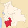 | |
| Municipalities (and seats) |
| |
This article is issued from Wikipedia - version of the 6/16/2016. The text is available under the Creative Commons Attribution/Share Alike but additional terms may apply for the media files.