Jerome Avenue
| Length | 5.6 mi[1] (9.0 km) |
|---|---|
| South end |
|
| Major junctions |
|
| North end |
|
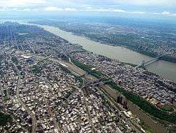
Jerome Avenue is one of the longest thoroughfares in the New York City borough of the Bronx, New York, United States. The road is 5.6 miles (9.0 km) long and stretches from Highbridge general area to Woodlawn. Both of these termini are with the Major Deegan Expressway which runs parallel to the west. Most of the elevated IRT Jerome Avenue Line runs along Jerome Avenue. The Cross Bronx Expressway interchanges with Jerome and the Deegan. Though it runs through what is now the West Bronx neighborhood, Jerome Avenue is the dividing avenue between the nominal "West" and "East" streets in the Bronx; Fifth Avenue serves Manhattan in the same capacity.
Street description

The south end of Jerome Avenue is at interchange 5 of the Major Deegan Expressway.[1] The road begins as a divided highway, intersecting with 161st Street, which goes to Yankee Stadium and its station of the IRT Jerome Avenue Line. Jerome merges into the road to the Macombs Dam Bridge and heads north, paralleling Macombs Dam Park. After some intersections with local roads, Jerome Avenue intersects with 167th Street which at the intersection which, west of there, is named Edward L. Grant Highway. Just east of the intersection is the 167th Street station, another station along the way. Several blocks north, 170th Street intersects, just before crossing the Edward L. Grant Highway. A subway station is also present here.
Mt. Eden Avenue intersects in Morris Heights and the Cross Bronx Expressway does soon after.[1] West 176th Street becomes concurrent with Jerome for a short time. The roads soon split, West 176th now known as East 176th. North the intersection with Tremont Avenue, Burnside Avenue intersects as Jerome Avenue leaves Morris Heights. 183rd street is the next major intersection, in University Heights. Fordham Road, both East and West intersect in University Heights. Saint James Park is passed to the east of Jerome, south of the intersection with Kingsbridge Road. As Jerome passes Lehman College, Bedford Park Boulevard (200th Street) intersects. Jerome Avenue then crosses the Mosholu Parkway on an overpass, after passing the train yard for the Avenue's IRT line.
Jerome Avenue intersects with Gun Hill Road as it enters Woodlawn.[1] Here, Van Cortlandt Park is to the west. The final station on the IRT line is located in Woodlawn, just before intersecting Bainbridge Avenue. Jerome Avenue continues, cuts between Van Cortlandt Park and Woodlawn Cemetery, and comes to an end at the Major Deegan and 233rd Street. The road continues as a service road for the Major Deegan, until it reaches the Bronx-Westchester border, where it becomes Central Park Avenue (NY 100), one of the main streets of the city of Yonkers.
History
Jerome Avenue was put together as a plank road in 1874 for $375,000.[2] It appeared on maps as Central Avenue, because it started from Macombs Dam Bridge to Jerome Park Racetrack. Borough President Louis F. Haffen selected contractors in 1897 to pave Jerome Avenue. Three sections of the road were to be remodeled, costing the Bronx about $136,505.[3] The street was to be renamed after an unknown city alderman.[2] Kate Hall Jerome, wife of Lawrence Jerome, was furious, replacing all the signs with the name Jerome Avenue in honor of Jerome Park Racetrack opened by her husband's financier brother, Leonard Jerome in 1866. When the subway line was commissioned, Jerome went from rural road to commercial artery.
The southern part of the avenue, from the intersection with 161st Street, formed the western edge of Macombs Dam Park. The parkland was alienated by the state legislature to enable construction of a new Yankee Stadium. Lower portions of the thoroughfare were demapped by the City Planning Commission,[4] followed by the Department of City Planning's 2006 release of the Bronx Harlem River Waterfront Bicycle and Pedestrian Study.[5][6][7] The Park Plaza Apartments at 1005 Jerome Avenue, one of the borough's first and most prominent Art Deco apartment houses and a New York City landmark since 1981, was overlooked in the environmental impact statement and is now in the shadow of the completed new stadium.
Subway
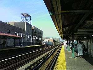
The first station along the Jerome Avenue elevated line is the 161st Street – Yankee Stadium station, just after the Macombs Dam Bridge and the Major Deegan. The station is served by the 4 B D trains. The station was opened in June 1917 and is the only one on this line which never served trains of the IRT Ninth Avenue Line before it was decommissioned (the lines merged north of here). All further stations north now serve only the 4 train. The 167th Street station is the next going north. The station was opened on the same day as the 161st Street – Yankee Stadium station.[8] The 170th Street station is about the same as the 167th Street station in statistics,[9] and is the southernmost station to actually be located over Jerome Avenue itself. The Mount Eden Station is the final one before the Cross Bronx Expressway intersects Jerome.[10] The next station is the 176th Street station, located at the 176th/Jerome intersection.[11]
The next station along the line is the express Burnside Avenue station.[12] 183rd Street, Fordham Road and Kingsbridge Road are the next three stations.[13][14][15] The station after is Bedford Park Boulevard, which has access to Lehman College. The next-to-last station along the way is Mosholu Parkway, located in Van Cortlandt Park. Unlike the others, this station and the last one, Woodlawn, were opened later. The line and 4 train come to an end at the Woodlawn Station.[16]
See also
- Fifth Avenue, Jerome Avenue's counterpart in Manhattan
References
- 1 2 3 4 Overview Map of Jerome Avenue (Map). Google Maps. Retrieved 2007-11-06.
- 1 2 John McNamara (1991). History in Asphalt: The Origin of Bronx Street and Place Names (PDF). Google Books. Retrieved 2007-11-09.
- ↑ "TO PAVE JEROME AVENUE; Contractors Named for Work on Three Sections of the Thoroughfare". New York Times. August 13, 1897. Retrieved 2007-11-06.
- ↑ CITY PLANNING COMMISSION 2006
- ↑
- ↑
- ↑
- ↑ nycsubway.org – IRT Woodlawn Line: 167th Street
- ↑ nycsubway.org – IRT Woodlawn Line: 170th Street
- ↑ nycsubway.org – IRT Woodlawn Line: Mt. Eden Avenue
- ↑ nycsubway.org – IRT Woodlawn Line: 176th Street
- ↑ nycsubway.org – IRT Woodlawn Line: Burnside Avenue
- ↑ nycsubway.org – IRT Woodlawn Line: Fordham Road
- ↑ nycsubway.org – IRT Woodlawn Line: 183rd Street
- ↑ nycsubway.org – IRT Woodlawn Line: Kingsbridge Road
- ↑ nycsubway.org – IRT Woodlawn Line: Mosholu Parkway
Coordinates: 40°51′42.22″N 73°54′6.61″W / 40.8617278°N 73.9018361°W