Morris Heights, Bronx
| Morris Heights | |
|---|---|
| Neighborhood of The Bronx | |
|
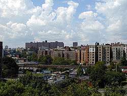
Featherbed Lane, seen from Grand Concourse | |
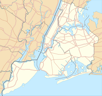 Morris Heights  Morris Heights  Morris Heights Location in New York City | |
| Coordinates: 40°50′59″N 73°55′11″W / 40.8498223°N 73.9198590°W | |
| Country |
|
| State |
|
| City |
|
| Borough |
|
| Area[1] | |
| • Total | 1.30 km2 (0.502 sq mi) |
| Population (2011)[1] | |
| • Total | 36,779 |
| • Density | 28,000/km2 (73,000/sq mi) |
| Economics | |
| • Median income | $24,677 |
| ZIP codes | 10452, 10453 |
| Area code | 718, 347, 646 |
Morris Heights is a residential neighborhood located in the West Bronx. The neighborhood is part of Bronx Community Board 5. Its boundaries, starting from the north and moving clockwise are: West Burnside Avenue to the north, Jerome Avenue to the east, the Cross-Bronx Expressway to the south, and the Harlem River to the west. University Avenue is the primary thoroughfare through Morris Heights. The local subway is the IRT Jerome Avenue Line, operating along Jerome Avenue. ZIP codes include 10453 and 10452. The area is patrolled by the 46th Precinct[2] located at 2120 Ryer Avenue in Fordham. New York City Housing Authority (NYCHA) property in the area is patrolled by P.S.A. 7 at 737 Melrose Avenue in the Melrose section of the Bronx.
Demographics
Morris Heights has a population of around 36,779. Almost half the population lives below the poverty line and receives public assistance (TANF, Home Relief, Supplemental Security Income, and Medicaid). The vast majority of residents in the area are of Puerto Rican, Dominican, or African American descent. The majority of households are renter occupied.[1][3]
Land use and terrain
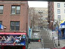
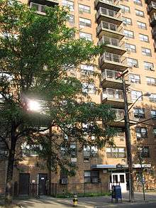
Morris Heights is dominated by 5 and 6-story tenement buildings, older multi-unit homes, vacant lots, and newly constructed subsidized attached multi-unit townhouses and apartment buildings. A significant percentage of the early 20th century housing stock was structurally damaged by arson and eventually razed by the city. The neighborhood contains one of the highest concentrations of NYCHA projects in the Bronx. The total land area is less than half one square mile. The terrain is elevated and very hilly. Stair streets connect areas located at different elevations.
Low income public housing projects

Ten NYCHA developments are located in Morris Heights.[4]
- Harrison Avenue Rehab (Group A); one, 5-story rehabilitated tenement building.
- Harrison Avenue Rehab (Group B); four rehabilitated buildings, 5 and 6-stories tall.
- Macombs Road; two rehabilitated buildings, 5 and 6-stories tall.
- Morris Heights Rehab; three rehabilitated tenement buildings, 5 and 6-stories tall
- Sedgewick Houses; seven buildings, 14 and 16-stories tall.
- University Avenue Rehab; four, 6-story rehabilitated tenement buildings.
- West Tremont Avenue-Sedgwick Avenue Area; one, 12-story building.
- West Tremont Rehab (Group 1); two rehabilitated tenement buildings, 5 and 6-stories tall.
- West Tremont Rehab (Group 3); one, 5-story rehabilitated tenement building.
- West Tremont Rehab (Group 2); two, 6-story rehabilitated tenement buildings.
Urban renewal
After a wave of arson ravaged the low-income communities of New York City throughout the 1970s, many if not most residential structures in Morris Heights were left seriously damaged or destroyed. The city began to rehabilitate many formerly abandoned tenement-style apartment buildings and designate them low-income housing beginning in the late 1970s. Also many subsidized attached multi-unit townhouses and newly constructed apartment buildings have been or are being built on vacant lots across the neighborhood.
Origin of hip hop subculture
Morris Heights is believed to be the site where Hip Hop culture originated in the 1970s. However, in the late 1960s and early 1970s several disc jockeys protected by the Black Spades (a violent but organized gang that promoted their own form of justice; originally from Bronxdale Housing Projects & later recruited several members from Bronx River Housing Projects), and other gangs took their DJ led block parties in the South Bronx, the East Side of the Bronx and the West Side.[5][6][7][8][9][10]
Education
Public:
- PS 109 (Popham Avenue and West Tremont Avenue)
- PS 204: Morris Heights (West 174th Street and Nelson Avenue)
- PS 230/MS 229: Roland N. Patterson (Harlem River Park Bridge and Sedgwick Avenue)
- PS 306 (West Tremont and Jerome Avenues)
- PS 396/MS 390 (West Burnside and Andrews Avenues)
- IS 303: The Leadership and Community Service Academy (West 176th Street and Macombs Road)
- MS 232: The Academy School (West 176th Street and Macombs Road)
- MS 331: The Bronx School of Science Inquiry and Investigation (West Tremont and Davidson Avenue)
- HS 365: The Academy for Language and Technology High School (West 176th Street and Macombs Road)
Parochial:
- Holy Spirit School (Closed)[11]
Transportation
- Bx3: 238th Street station (1 train) to George Washington Bridge Bus Terminal (via University Avenue)
- Bx18: to –170th Street station (B D trains) (via Macombs Road)
- Bx32: VA Hospital to Third Avenue – 138th Street station (6 <6> trains, via Morris Avenue)
- Bx36: Castle Hill to George Washington Bridge Bus Terminal (via 180th Street)
- Bx40: SUNY Maritime College to River Park Towers (via Tremont and Burnside Avenues)
- Bx42: Throggs Neck to River Park Towers (via Tremont and Burnside Avenues)
The IRT Jerome Avenue Line and the IND Concourse Line are the subway lines that serve the neighborhood.
- 170th Street (4 train)
- Mount Eden Avenue (4 train)
- 176th Street (4 train)
- Burnside Avenue (4 train)
- 170th Street (B D trains)
- 174th–175th Streets (B D trains)
- Tremont Avenue (B D trains)
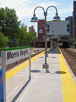
- Morris Heights (Metro-North station) (Hudson Line)
References
- 1 2 3 "Morris Heights neighborhood in New York". Retrieved August 21, 2015.
- ↑ "46th Precinct". Retrieved 27 November 2015.
- ↑ Bronx Community District 5
- ↑ NYCHA
- ↑ Chang, Jeff; DJ Kool Herc (2005). Can't Stop Won't Stop: A History of the Hip-Hop Generation. Macmillan. ISBN 0-312-30143-X.
- ↑ Castillo-Garstow, Melissa (1 March 2005). "Latinos in Hip Hop to Reggaeton". Latin Beat Magazine. 15 (2): 24(4).
- ↑ Rojas, Sal (2007). "Estados Unidos Latin Lingo". Zona de Obras. Zaragoza, Spain (47): 68.
- ↑ Allatson, Paul. Key Terms in Latino/a Cultural and Literary Studies. Malden, MA: John Wiley & Sons, 2007, 199.
- ↑ Schloss, Joseph G. Foundation: B-boys, B-girls and Hip-Hop Culture in New York. New York: Oxford University Press, 2009, 125.
- ↑ From Mambo to Hip Hop. Dir. Henry Chalfant. Thirteen / WNET, 2006, film
- ↑ Powell, Michael. "Teachers Ask About Mission They Lived By". The New York Times. Retrieved 27 November 2015.
External links
| Wikimedia Commons has media related to Morris Heights, Bronx. |
- Living in Morris Heights - slideshow by The New York Times