Jiji, Nantou
Coordinates: 23°49′48″N 120°46′59″E / 23.83°N 120.783°E
Jiji (Chinese: 集集; pinyin: jíjí; Wade–Giles: Chi-chi; Pe̍h-ōe-jī: Chi̍p-chi̍p) or Chichi is an urban township located in the west central portion of Nantou County, Taiwan. In the past, the Jiji township encompassed a much larger area and included the present-day Shueili Township, but today's Jiji is the smallest of Taiwan's townships by area.
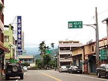
The epicenter of the major 1999 earthquake in Taiwan was located in and named after the township. Jiji today is a popular destination for domestic tourists and daytrippers. The township's famous early-20th-century Japanese-era railway station, the government-run Endemic Species Research Institute, the annual lantern exhibition held during Chinese New Year, as well as other features, attract many weekend visitors. The most popular activity among visitors to Jiji, however, is cycling. Visitors may rent bicycles, tandem bicycles, three-wheeled tricycles or electric-powered bicycles to tour the area's many backroads. A wide selection of local agricultural products can be seen for sale around the township.
In March 2012, it was named one of the Top 10 Small Tourist Towns by the Tourism Bureau of Taiwan.[1]
History
Han Chinese from Zhangzhou began arriving in the area in 1771.[2] The name originates from "Chiv-Chiv", a phrase in the Formosan languages.
Empire of Japan
During the Japanese era (1895–1945), Jiji was a collection and shipping point for camphor produced in the surrounding areas. By 1940, it was administrated as Shūshū Town (Japanese: 集集街), Niitaka District (新高郡), Taichū Prefecture.
Republic of China
In 1946, the district name was changed to Yushan District (玉山區) under Shuili Township (水裡鄉), Taichung County. In 1950, Jiji separated from Shuili, creating Jiji Township (集集鎮) and Shueili Township.[3]
Demographics
Population: 11,390[4]
Villages: 11
Geography
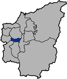
Jiji is bordered by Jhongliao to the north, Mingjian to the west, Zhushan and Lugu to the south, and Shueili to the east. The Zhuoshui River flows westward along the south border of the township. Jiji Township has a total area of 49.72 square kilometres. The lowest point in the township lies at 230 m above sea level and its highest point is Big Jiji Mountain (集集大山) at 1392 m above sea level. The township is very mountainous and is surrounded by mountains on all sides.[4] Climbing up the top, visitors have a great view of the region including the nearby Sun Moon Lake. There are side trails for enthusiastic hikers. During World War II, a U.S. bomber was shot down by the Japanese artillery, and there 4 airmen killed.
Administrative divisions
- Jiji Village
- Heping Village
- Linwei Village
- Tianliao Village
- Ailiao Village
- Yuying Village
- Wucuo Village
- Bazhang Village
- Yongchang Village
- Guangming Village
- Fushan Village
Politics
The 2014 mayoral election was won by 29-year-old Chen Chi-heng of the newly formed Trees Party, in what was characterized by the media as a shock result.[5]
Tourist attractions
- Conservation Education Center
- Jiji Military History Park
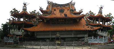
- Mingxin Academy
Transportation

Jiji Township is served by Longquan Station and Jiji Station of the Taiwan Railway Administration.
See also
| Wikimedia Commons has media related to Jiji Township, Nantou. |
References
- ↑ Wong, Maggie Hiufu (2012-03-30). "Taiwan names its 10 top small tourist towns". CNN Go. Retrieved 2012-03-31.
- ↑ "About Chichi(關於集集)" (in Chinese). 2007-02-22.
- ↑ zh:集集鎮#歷史. Missing or empty
|title=(help); - 1 2 "Geography and Climate (地理氣候)" (in Chinese). 2007-02-22.
- ↑ 集集鎮長陳紀衡當選,太陽花學運如何改變一個人 (in Chinese), Commonwealth Magazine, 2014-12-07
External links
- Jiji Township Office (Chinese)
Cities and townships of Nantou County | ||
|---|---|---|
| Cities |  | |
| Urban townships | ||
| Rural townships | ||
| Mountain indigenous townships | ||