Kaman, Rajasthan
| Kaman कामां कम्य्वन | |
|---|---|
| city | |
| Nickname(s): ब्रज भूमि | |
 Kaman  Kaman Location in Rajasthan, India | |
| Coordinates: 27°39′N 77°16′E / 27.65°N 77.27°ECoordinates: 27°39′N 77°16′E / 27.65°N 77.27°E | |
| Country |
|
| State | Rajasthan |
| District | Bharatpur |
| Government | |
| • Type | B.J.P. |
| • M.L.A. | ku.jagat Singh |
| Elevation | 189 m (620 ft) |
| Population (2011) | |
| • Total | 38,040 |
| Languages | |
| • Official | Hindi |
| Time zone | IST (UTC+5:30) |
| PIN | 321022 |
| 05640 | 05640 |
| Vehicle registration | RJ 05 |
Kaman is a town in Bharatpur district of Rajasthan State, India.
Geography
Kaman is located at 27°39′N 77°16′E / 27.65°N 77.27°E.[1] with an approximate elevation of 189 meters (620 feet) above mean sea level. It borders the states of Haryana to the west and Uttar Pradesh to the North. These two borders meet in the village of Nonera, Sahera, Dhilawati and create a triangular pattern. The major villages included are: Kanwara, Bilang, Bolkhera, Jurehra, Bilond, Indrauli, Akata,[Tayara] Lewda, Somka, Sehsan, chicharwari, Sablana, Birar, Dhamari, Satwas, Anchwara, Amrooka, Garh Ajan, Moosepur, Luhesar, Pai, Bmni, Nonera, Sahera, Khedli Gumani (Khedi Nogaiyan), nagla gopinath, Unchera, Bhandara, Tayra, Gurira, Ladlaka, Gundgaon, Angarawali, Gamdi and Sonokhar.
History
Kaman is considered to be a very old and sacred town for Hindus as it forms part of the "Braj" (or "Brij") area where Lord Krishna spent his early life. It is also known as Kamawan. Its former name is said to have been Brahmapur, but Raja Kamsen, the maternal grandfather of Krishna changed it to Kaman after his own name. Kaman is the shorter name of Kadambawana for numerous Kadamba tree found here.
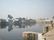
It is a place of pilgrimage, annually visited by a large number of Vaishnava in the month of Bhadon as part of Vanyatra. Kaman also has 84 kunds (ponds), many of which have dried up. It was under the rule of king Jaipur for a long time, but was conquered and annexed by Maharaja Jawahar Singh. Some palaces of the Jaipur chiefs still exist here. Maharaja Jai Singh took the idols of Madan Mohanji and Gokul Chandramanji to his city of Jaipur, but due to some reason the idols were brought back to Kaman after a short stay at Bikaner. A fair is held in the rainy season called 'Parikrama Mela' or Parkamma at the higher ground of 'Cheel Mahal' (Eagle palace). The palace was called so due to its elevation.
This small town is known for some of Rajasthan's prominent temples of Rajasthan, such as Govindaji Temple, Vimala Kunda, Kameswara Mahadeva Siva Temple and Chaurasi Khamba.
Chaurasi Khamba
Chaurasi Khamba, situated to the west of the town, is a renowned temple known for its significance and magnitude. It is an important tourist destination in Bharatpur. Eighty-four ancient beautifully carved pillars carefully festoon the monument and thus obtained the name Chaurasi Khamba temple. It resembles a monument at Gokula, the said birthplace of Krishna. The temple is also considered to have been the abode of Pandava Brothers during their 14-years exile. It is believed that the debate between Yaksha and Yudhistra occurred at a nearby pond named Dharam Kund.
Transport
Kaman is well connected to Bharatpur, Alwar, Jaipur, Delhi, Faridabad, Gurgaon, Ambala, Panipat, Chandigarh and many other major cities of North-West India by road. There are regular buses to Kaman from these cities.
The nearest railway station is at Kosi Kalan, Deeg. Other major junctions near to Kaman are Bharatpur and Mathura.
The nearest town kumher, deeg, nadbai. pahari, jurher .
Education
Many school in kaman town 1.Anamika senior sec. school kaman Bharatpur 2.Sanskar education Academy school kaman Bharatpur 3.Rajendra bal Se.sec.school kaman Bharatpur etc.