Kampong Seila District
| Kampong Seila ស្រុកកំពង់សីលា | |
|---|---|
| District (srok) | |
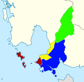 Preah Sihanouk Province districts: Krong Preah Sihanouk (dark red), Stueng Hav (yellow), Prey Nob (blue), Kampong Seila (green) | |
| Country |
|
| Province | Preah Sihanouk Province |
| Communes | 4 |
| Villages | 14 |
| Population (2008)[1] | |
| • Total | 14,965 |
| Time zone | +7 |
| Geocode | 1804 |
Kampong Seila District (Khmer: ស្រុកកំពង់សីលា) is a district (srok) in south-western Cambodia, which formerly belonged to Koh Kong Province. In January 2009 King Norodom Sihamoni incorporated the district into Preah Sihanouk Province per Royal Decree,[2] which states: "The administrative boundaries of Preah Sihanouk municipality and Koh Kong province shall be adjusted by sub-dividing land from Kampong Seila district in whole and partial land of Sre Ambil district in Koh Kong province to Preah Sihanouk municipality." Officials were assigned to create a National Workshop - also in relation to other provinces - and to process all necessary administrative tasks. The National Institute of Statistics of Cambodia refers in its most recent and preliminary studies to a successful integration of the district, including maps,[3] although concluding statistics and numbers are expected to be available with the next full report. Preah Sihanouk Province's new official domain already runs administration of Kompong Seila district.[4]
Geography
The district's northern part encompasses the Kirirom National Park and to the east it constitutes the south-western promontory of the Preah Monivong National Park of the Elephant Mountains. The Elephant Mountain range of uplifted Mesozoic substrates is an important watershed for the large Tonle Sap system in central Cambodia. The intact habitat is subject to concerted maintenance of five major protected areas.[5]
Throughout the diamond-shaped province rolling hills are predominant and the area flattens towards the south where it almost touches the sea. For nearly its entire length the National Highway 4 (Cambodia) loops through the district from north to south.
Settlements
Kampong Seila consists of 4 communes (Sangkat), which are divided into 14 villages (phum). The district's capital is called Kompong Seila,which is in turn the center of Kampong Seila's capital commune. Its distance from Phnom Penh is roughly 135 km and from Sihanoukville (city) around 85 km.
Markets, pagodas and administrative units are centered on the vital National Road #4. Kompong Seila's overwhelmingly rural population engages in rice farming, forestry and subsidiary crop cultivation, such as gourds and cucumbers.[6][7]
Demographics and Education
Within the village seat of the district there are 1400 people and about 280 households. The main school is the T.C.Kampong Seila school.
| Kampong Seila District[8] | ||
| Khum (Commune) | Phum (Villages) | |
|---|---|---|
| Chamkar Luong | Chamkar Luong, Boeng Trach, Samdech Ta | |
| Kampong Seila | Cham Srei, Krang at, Thmei, Veal | |
| Ou Bak Roteh | Prey Praseth, Stueng Chral, Stueng Samraong | |
| Stueng Chhay | Kirivoan, Ou Ta Hay, Stueng Chhay Khang Tbong, Stueng Chhay Khang Cheung | |
Agriculture
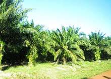
Southeast Asia's fourth largest palm oil producer - MRICOP planted oil palm trees on 477 ha in Kampong Seila.[9] While MRICOP frequently highlights economic advantages, others are concerned about the negative impact of mono-cultures on the local Eco-system, dubious land concession practices and demographic irritations.[10][11]
See also
- Kirirom National Park
- Preah Monivong National Park
- Dâmrei Mountains
- Preah Sihanouk Province
- Koh Kong Province
References
- ↑ General Population Census of Cambodia, 2008: Village Gazetteer. National Institute of Statistics. February 2000.
- ↑ http://www.dfdl.com/resources/library/legal.../16-law-updates-cambodia?
- ↑ http://www.nis.gov.kh/nis/CIES/CIES2014_Preliminary_Report_En.pdf
- ↑ http://www.sihanoukville.gov.kh/index.php/en/
- ↑ http://www.cambodiatravel.org/travel-guide/cardamom-and-elephant-mountains.html
- ↑ "Background of T.C.Kampong Seila school". Apsara Foundation. Retrieved January 31, 2009.
- ↑ http://www.cambodiainvestment.gov.kh/
- ↑ Cambodia e-gov "Koh Kong" Accessed June 8, 2008
- ↑ http://www.mongreththy.com/
- ↑ http://www.forestpeoples.org/sites/fpp/files/publication/2011/11/oil-palm-expansion-southeast-asia-2011-low-res.pdf
- ↑ http://www.cifor.org/publications/pdf_files/OccPapers/OP-51.pdf
External links
- Preah Sihanouk Province official homepage
- Ministry of Tourism
- National Institute of Statistics of Cambodia
- Sihanoukville Autonomous Port
- Ministry of Public Works and Transport