Thma Puok District
| Thma Puok ស្រុកថ្មពួក | |
|---|---|
| District (srok) | |
|
Part of the Banteay Chhmar site | |
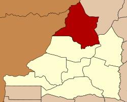 Map showing the location of the district within Banteay Meanchey Province. | |
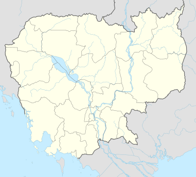 Thma Puok Location in Cambodia | |
| Coordinates: 13°45′N 103°0′E / 13.750°N 103.000°ECoordinates: 13°45′N 103°0′E / 13.750°N 103.000°E | |
| Country |
|
| Province | Banteay Meanchey |
| Communes | 6 |
| Villages | 62 |
| Population (2008) | |
| • Total | 61,189 |
| Time zone | +7 |
| Geocode | 0107 |

Thma Puok (Khmer: ស្រុកថ្មពួក, "Crumbled Stone") is a district (Srok) in the north of Banteay Meanchey Province, in north-western Cambodia. The district capital is Thma Puok town located around 42 kilometres north of the provincial capital of Sisophon by road. The district shares a border with Thailand to the west and Oddar Meanchey Province to the north east. No national highway runs through the district but national road 56 from Sisophon to Samraong in Oddar Meanchey province crosses the district from north to south. The district is home to the large temple complex of Banteay Chhmar. The temple was built in the late 12th or early 13th century by Jayavarman VII and is a modest tourist destination.[1]
The district is easily accessed by road from Sisophon (42 km), Battambang (city) (110 km), Siem Reap (city) (144 km) and Samraong (71 km). Thma Puok district is the largest districts in Banteay Meanchey province by land area but has a relatively small population due to its isolation. Large parts of the district, especially in the north west towards Thailand, are largely unpopulated. There is one official border crossing with Thailand in Kouk Romiet commune. One provincial road begins at the border and runs south east through the district to an intersection at Sarongk in Svay Chek district. Another provincial road runs north from Banteay Chmar commune on National Road 56 to Banteay Ampil district in Oddar Meanchey province. Numerous smaller roads also run to the Thai border in the north western part of the district.[2]
Banteay Chhmar
Thma Puok is home to the gigantic temple complex of Banteay Chhmar. The temple was commissioned in the 12th Century by Jayavarman VII in honour of four army generals and his son, the Crown Prince Indravarman.[3] The temple complex covers over 500,000 feet (46,500 square meters) and due to its remote location near the Thai border has been a target of significant looting since the 1980s. In the past looters have dismantled entire walls of the temple to remove the carvings and bas reliefs. These treasures are then sold in the illegal antiquities black market.[4]
Location
Thma Puok district lies in the far north of the province and shares a border with Sa Kaeo Province of Thailand. Reading from the north clockwise, Thma Puok borders with Amphoe Ta Phraya of Thailand to the north west and Banteay Ampil district of Oddar Meanchey to the north east. The eastern border of the district is shared with Phnom Srok district. To the south, the district shares a border with Svay Chek district. The western border of the district also joins with Ta Phraya district of Sa Kaeo province in Thailand.[5]
Administration
The Thma Puok district governor reports to His Excellency Oung Ouen, the Governor of Banteay Meanchey. The following table shows the villages of Thma Puok district by commune.
| Khum (Commune) | Phum (Villages) |
|---|---|
| Banteay Chhmar | Kouk Samraong Koet, Kbal Tonsaong, Banteay Chhmar Cheung, Bangtey Chmar Khang Lech, Kbal Krabei, Banteay Chhmar Tboung, Trapeim Thlok, Thma Daekkeh, Thlok, Kouk Samraong Lech, Srah Chrey, Prey Changha, Prasat Tbeng, Dang Rek |
| Kouk Kakthen | Dei, Sdau, Treas, Kouk Kakthen, Ta Siev, Chonleas Dai, Ta Trai, Preah Chhor, Kouk Khpos |
| Kouk Romiet | Kouk Prich, Srae L'a, Kouk Romiet, Sdau, Thmei, Ta Lei, Sereika, Ta Song, Trapeang Samraong, Phlov Bambaek, Thma Chhatr, Voa Preng, Pram Minea, Sameakki, Banteay Mean Rit, Spean, Kandaol, Kdoeb Thmor, Boeng Ta Srei, Boeng Sokrom |
| Kumru | Andoung Khlong, Kumru, Ta Yueng, Aekakpheap, Phsar Thmei, Svay Chrum, Prey Veng |
| Phum Thmei | Kab Chaor, Kouk Svay, Rumlum Chrey, Thmei Lech, Thmei Kandal, Thmei Khang Tbong, Totea |
| Thma Puok | Thma Puok, Neak Ta, Voat Chas, Kasen, Svay, Thnal Dach, Anlong Trach |
Demographics
The district is subdivided into 6 communes (khum) and 62 villages (phum).[6] According to the 1998 Census, the population of the district was 53,536 persons in 10,860 households in 1998. This population consisted of 26,591 males (49.7%) and 26,945 females (50.3%). With a population of around 50,000 people, Thma Puok has one of the smaller district populations in Banteay Meanchey province. The average household size in Thma Puok is 4.9 persons per household, which is slightly smaller than the rural average for Cambodia (5.2 persons). The sex ratio in the district is 98.7%, with similar numbers of females and males.[7]
References
- ↑ Total Road Atlas of Cambodia 2006 (3rd ed.). Total Cambodge. 2006. p. 32.
- ↑ Cambodia Road Network (Version 03-00 ed.). Ministry of Public Works and Transport. 2001.
- ↑ "Banteay Chhmar, Cambodia". Global Heritage Fund. 2008. Archived from the original on February 7, 2009. Retrieved 2009-03-29.
- ↑ Preston, Douglas (August 2000). "The Temples of Angkor: Still Under Attack". National Geographic. Retrieved 2009-03-29.
- ↑ "Banteay Meanchey Provincial Resources". Ministry of Commerce. Archived from the original on January 5, 2009. Retrieved 2009-03-26.
- ↑ "Banteay Meanchey Administration". Royal Government of Cambodia. Retrieved 2009-03-26.
- ↑ General Population Census of Cambodia, 1998: Village Gazetteer. National Institute of Statistics. February 2000. pp. 1–15.
External links
- Banteay Meanchey at Royal Government of Cambodia website
- Banteay Meanchey at the Ministry of Commerce website
Capital: Serei Saophoan | ||
| Mongkol Borei District |  | |
| Phnum Srok District | ||
| Preah Netr Preah District | ||
| Ou Chrov District | ||
| Krong Serei Saophoan | ||
| Thma Puok District | ||
| Svay Chek District | ||
| Malai District | ||
| Krong Paoy Paet | ||