Karcsa
| Karcsa | |
|---|---|
 Karcsa Location of Karcsa | |
| Coordinates: 48°18′38″N 21°47′50″E / 48.31050°N 21.79726°ECoordinates: 48°18′38″N 21°47′50″E / 48.31050°N 21.79726°E | |
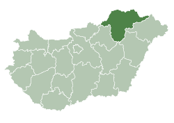
| Country | Hungary |
| County | Borsod-Abaúj-Zemplén |
| Area | |
| • Total | 43.68 km2 (16.86 sq mi) |
| Population (2004) | |
| • Total | 2,004 |
| • Density | 45.87/km2 (118.8/sq mi) |
| Time zone | CET (UTC+1) |
| • Summer (DST) | CEST (UTC+2) |
| Postal code | 3963 |
| Area code(s) | 47 |
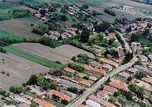
Karcsa is a village in Borsod-Abaúj-Zemplén county, Hungary, which dates back to the time of the Hungarian settlement (late 9th century). There is a 1000-year-old graveyard in the neighboring town Karos and archaeological discoveries confirm this. The village is well known for its Romanesque church built probably around 1000 after the Huns converted to Christianity. Karcsa was situated in what was north-central Hungary from the founding of the country until 1920 when the Treaty of Trianon split Hungary, depriving it of 70% of its territory and leaving 60% of its people in surrounding countries. Now it is a border town on the northern Hungarian border with Slovakia. Karcsa has a small lake which is quite popular with fishermen and campers in summer and for skating in winter. Karcsa, although it doesn't have any claim to fame other than its church, is near many popular sightseeing areas: Nagy Rozvagy which has an annual summer "ancient village" festival, showing how the Huns lived, and Karos, the 1000-year-old Hun cemetery, and the Tokaj wine region.


Notes
References
- Gerevich T. (1938): Magyarország románkori emlékei. (Die romanische Denkmäler Ungarns.) Egyetemi nyomda. Budapest
- Gerő, L. (1984): Magyar műemléki ABC. (Hungarian Architectural Heritage ABC.) Budapest
- Gervers-Molnár, V. (1972): A középkori Magyarország rotundái. (Rotunda in the Medieval Hungary). Akadémiai, Budapest
- Henszlmann, I. (1876): Magyarország ó-keresztyén, román és átmeneti stylü mű-emlékeinek rövid ismertetése, (Old-Christian, Romanesque and Transitional Style Architecture in Hungary). Királyi Magyar Egyetemi Nyomda, Budapest
- Genthon I. (1959): Magyarország műemlékei. (Architectural Heritage of Hungary). Budapest
- Szilágyi A. (2008): A Kárpát-medence Árpád-kori rotundái és centrális templomai. (The Rotunda and Central Building Churches in the Carpathian Basin.) Semmelweis Kiadó, Budapest
- Szőnyi O. (É.n.): Régi magyar templomok. Alte Ungarische Kirchen. Anciennes églises Hongroises. Hungarian Churches of Yore. A Műemlékek Országos Bizottsága. Mirályi Magyar Egyetemi Nyomda, Budapest.
- Jósvainé Dankó K. (é.n.): Karcsa. Református templom. (Karcsa. Reformed Churches.) Tájak, korok múzeumok kiskönyvtára, 572. TKM Egyesület, Budapest