Cigánd
| Cigánd | ||
|---|---|---|
| ||
 Cigánd Location of Cigánd | ||
| Coordinates: 48°15′48″N 21°53′31″E / 48.26328°N 21.89185°ECoordinates: 48°15′48″N 21°53′31″E / 48.26328°N 21.89185°E | ||
| Country |
| |
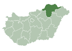
| County | Borsod-Abaúj-Zemplén | |
| Area | ||
| • Total | 56.79 km2 (21.93 sq mi) | |
| Population (2008) | ||
| • Total | 2,925 | |
| • Density | 51.5/km2 (133/sq mi) | |
| Time zone | CET (UTC+1) | |
| • Summer (DST) | CEST (UTC+2) | |
| Postal code | 3973 | |
| Area code(s) | 47 | |

Cigánd is a small town in Borsod-Abaúj-Zemplén county, Northern Hungary, 80 kilometres (50 miles) from the county capital Miskolc.
History
The area has been inhabited since ancient times . Before the Hungarians conquered the area, Slavic and Avar tribes lived here.
Cigánd was first mentioned in documents in 1289. Its residents were fishers, hunters and serfs. In 1347 the village was divided into two parts because of a debate over ownership, the two parts were called Small Cigánd and Greater Cigánd. The two parts were reunited in 1922.
After the regulation of the Tisza river, the village got arable land, and from this time the residents grew potatoes.
Cigánd was granted town status on July 1, 2004.
International relations
Twin towns — Sister cities
Cigánd is twinned with:
External links
This article is issued from Wikipedia - version of the 3/6/2016. The text is available under the Creative Commons Attribution/Share Alike but additional terms may apply for the media files.