Taktaszada
| Taktaszada | ||
|---|---|---|
| ||
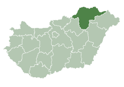
 Taktaszada Location of Taktaszada | ||
| Coordinates: 48°06′37″N 21°10′08″E / 48.11019°N 21.16883°ECoordinates: 48°06′37″N 21°10′08″E / 48.11019°N 21.16883°E | ||
| Country |
| |
| County | Borsod-Abaúj-Zemplén | |
| Area | ||
| • Total | 25.74 km2 (9.94 sq mi) | |
| Population (2004) | ||
| • Total | 2,095 | |
| • Density | 81.39/km2 (210.8/sq mi) | |
| Time zone | CET (UTC+1) | |
| • Summer (DST) | CEST (UTC+2) | |
| Postal code | 3921 | |
| Area code(s) | 47 | |

Taktaszada is a village in Borsod-Abaúj-Zemplén county, Hungary.
External links
- Street map (Hungarian)
This article is issued from Wikipedia - version of the 7/24/2015. The text is available under the Creative Commons Attribution/Share Alike but additional terms may apply for the media files.