Nyékládháza
| Nyékládháza | ||
|---|---|---|
| ||
 Nyékládháza | ||
| Coordinates: 47°59′30″N 20°50′13″E / 47.99175°N 20.83706°E | ||
| Country |
| |
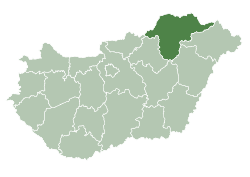
| County | Borsod-Abaúj-Zemplén | |
| Area | ||
| • Total | 24.53 km2 (9.47 sq mi) | |
| Population (2006) | ||
| • Total | 5,108 | |
| • Density | 202.08/km2 (523.4/sq mi) | |
| Time zone | CET (UTC+1) | |
| • Summer (DST) | CEST (UTC+2) | |
| Postal code | 3433 | |
| Area code(s) | 46 | |

Nyékládháza is a small town in Borsod-Abaúj-Zemplén county, northern Hungary, 20 kilometres (12 miles) from county capital Miskolc.
History
The area has been inhabited since ancient times; archaeological finds include an Avar cemetery. The villages Mezőnyék and Ládháza came into being around the conquest of Hungary; they were mentioned first in 1270 and 1293, respectively, although Mezőnyék had a different name then and had this name only from the 14th century. The name changes indicate that the villages were destroyed several times, but were rebuilt again and again.
The two villages were unified in 1932 under the name Nyékládháza. The village got town status in 2003.
Tourist sights, programs
- Szepessy-Egry manor
- Baroque Protestant church
- Lake Nyéki
- Saint's Day Fair in August
International relations
Twin towns — Sister cities
Nyékládháza is twinned with:
External links
Coordinates: 47°59′N 20°50′E / 47.983°N 20.833°E
This article is issued from Wikipedia - version of the 5/3/2015. The text is available under the Creative Commons Attribution/Share Alike but additional terms may apply for the media files.