Kherson Oblast
| Kherson Oblast Херсонська область Khersons’ka oblast’ | |||
|---|---|---|---|
| Oblast | |||
| |||
| Nickname(s): Херсонщина (Khersonshchyna) | |||
 | |||
| Country |
| ||
| Administrative center | Kherson | ||
| Government | |||
| • Governor | Andriy Hordeyev[1] (Petro Poroshenko Bloc "Solidarity"[1]) | ||
| Area | |||
| • Total | 28,461 km2 (10,989 sq mi) | ||
| Population (2015) | |||
| • Total | 1,063,803[2] | ||
| • Rank | Ranked 22nd | ||
| Time zone | EET (UTC+2) | ||
| • Summer (DST) | EEST (UTC+3) | ||
| Area code | +380-55 | ||
| ISO 3166 code | UA-65 | ||
| Vehicle registration | ВT | ||
| Raions | 18 | ||
| Cities (total) | 9 | ||
| • Regional cities | 3 | ||
| Urban-type settlements | 30 | ||
| Villages | 658 | ||
| FIPS 10-4 | UP08 | ||
| Website | www.oda.kherson.ua | ||
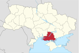
Kherson Oblast (Ukrainian: Херсонська область, translit. Khersons’ka oblast’; also referred to as Khersonshchyna – Ukrainian: Херсонщина) is an oblast (province) in southern Ukraine, just north of Crimea. Its administrative center is Kherson. The area of the region is 28,461 km², its population (as of 1 January 2012) is 1,083,367.[3]
Important cities in the oblast include:
- Kherson (capital)
- Kakhovka
- Nova Kakhovka
Geography
The Kherson Oblast is bordered by the Dnipropetrovsk Oblast on the north, the Black Sea and the disputed region of Crimea on the south, the Mykolayiv Oblast on the west, and the Azov Sea and the Zaporizhzhia Oblast on the east.
The Dnieper River runs through the oblast which includes the Kakhovka Reservoir.
The oblast includes (within Henichesk Raion) the northern portion of the Arabat Spit, a thin strip of land between the brackish Syvash and the Sea of Azov that is geographically part of the Crimean Peninsula. Due to Russia gaining de facto control of the Autonomous Republic of Crimea in 2014 the southern areas of Kherson are the only parts of the Crimean Peninsula under direct Ukrainian control.
Administrative divisions
The Kherson Oblast is administratively subdivided into 18 raions (districts) and 3 municipalities which are directly subordinate to the oblast government - Kherson (administrative center of the oblast), Nova Kakhovka, and Kakhovka. The Kherson municipality is subdivided into 3 urban districts. All information below is current as of 2015[2]
| Name | Ukrainian name | Area (km2) | Population census 2015 | Admin.center | Urban Population Only |
|---|---|---|---|---|---|
| Kherson | Херсон (місто) | 423 | 333,737 | Kherson (city) | 322,260 |
| Nova Kakhovka | Нова Каховкa (місто) | 223 | 68,205 | Nova Kakhovka + Tavriisk (city) | 62,128 |
| Kakhovka | Каховкa(місто) | 16 | 36,958 | Kakhovka (city) | 36,958 |
| Beryslav Raion | Бериславський (район) | 1,721 | 48,025 | Beryslav | 16,682 |
| Bilozerka Raion | Білозерський (район) | 1,534 | 66,564 | Bilozerka | 9,739 |
| Chaplynka Raion | Чаплинський (район) | 1,722 | 35,219 | Chaplynka | 12,638 |
| Henichesk Raion | Генічеський (район) | 3,008 | 59,991 | Henichesk | 33,748 |
| Hola Prystan Raion | Голопристанський (район) | 3,411 | 45,827 | Hola Prystan | 14,666 |
| Hornostaivka Raion | Горностаївський (район) | 1,018 | 19,788 | Hornostaivka | 6,681 |
| Ivanivka Raion | Іванівський (район) | 1,120 | 13,995 | Ivanivka | 4,560 |
| Kalanchak Raion | Каланчацький (район) | 916 | 21,568 | Kalanchak | 11,169 |
| Kakhovka Raion | Каховський (район) | 1,450 | 35,968 | Kakhovka (city) | N/A * |
| Novotroitske Raion | Новотроїцький (район) | 2,298 | 35,921 | Novotroitske | 14,979 |
| Novovorontsovka Raion | Нововоронцовський (район) | 1,005 | 21,442 | Novovorontsovka | 6,379 |
| Nyzhni Sirohozy Raion | Нижньосірогозький (район) | 1,209 | 15,985 | Nyzhni Sirohozy | 4,891 |
| Oleshky Raion | Олешківський (район) | 1,759 | 71,888 | Oleshky | 36,317 |
| Skadovsk Raion | Скадовський (район) | 1,456 | 47,930 | Skadovsk | 21,830 |
| Velyka Lepetykha Raion | Великолепетиський (район) | 1,000 | 16,827 | Velyka Lepetykha | 8,326 |
| Velyka Oleksandrivka Raion | Великоолександрівський (район) | 1,540 | 25,948 | Velyka Oleksandrivka | 9,747 |
| Verkhnii Rohachyk Raion | Верхньорогачицький (район) | 915 | 12,003 | Verkhnii Rohachyk | 5,698 |
| Vysokopillia Raion | Високопільський (район) | 701 | 15,121 | Vysokopillia | 6,148 |
.* Note: Though the administrative center of the rayon is housed in the city/town that its named after, cities do not answer to the rayon authorities only towns do; instead they are directly subordinated to the oblast government and therefore are not counted as part of rayon statistics.
At a lower level of administration, these district-level administrations are subdivided into:
- Settlements – 697, including:
- Villages – 658;
- Cities/Towns – 36, including:
- Cities of raion subordinance – 6 (Beryslav, Henichesk, Hola Prystan, Skadovsk, Tavriisk and Oleshky);
- Urban-type settlement – 30;
- Selsovets – 260.
The local administration of the oblast' is controlled by the Kherson Oblast Rada. The governor of the oblast is the Kherson Oblast Rada speaker, appointed by the President of Ukraine.

Demographics
The population of the oblast is 1,083,367 (2012), which is 2.4% of the total population of Ukraine. It is also ranked 21st by its population. The population density is 38 per km².
About 61.5% or 745,400 people live in urban areas of the Oblast and 38.5% or 467,600 people live in agricultural centers/villages. Men make up 46.7% or 565,400 people of the population, women make up 53.3% or 644,600 people, and pensioners make up 26.2% or 317,400 people of the Oblast population.
Ukrainian National Census (2001):
- Ukrainians – 82.0%
- Russians – 14.1%
- Belarusians – 0.7%
- Crimean Tatars – 0.5%
- Others – 2.7%
Age structure
- 0-14 years: 15.1%
 (male 83,397/female 79,303)
 - 15-64 years: 70.5%
 (male 364,907/female 393,933)
 - 65 years and over: 14.4%
 (male 50,404/female 104,856) (2013 official)
Median age
- total: 39.5 years

- male: 36.2 years

- female: 42.7 years
 (2013 official)
Attractions

- Askania-Nova
- Legendary tachanka monument
- Kurhan cemetery
- Shovkunek Art museum
- Saint-Yekaterynian Temple
Public opinion
During the 1991 referendum, 90.13% of votes in Kherson Oblast were in favor of the Declaration of Independence of Ukraine. A survey conducted in December 2014 by the Kyiv International Institute of Sociology found 1% of the oblast's population supported their region joining Russia, 94.9% did not support the idea, and the rest were undecided or did not respond.[4]
See also
References
- 1 2 Poroshenko appoints MP Andriy Hordeyev Kherson regional governor, Interfax-Ukraine (28 April 2016)
- 1 2 "Population Quantity". UkrStat (in Ukrainian). Retrieved 7 January 2016.
- ↑ State Statistics Committee of Ukraine
- ↑ Лише 3% українців хочуть приєднання їх області до Росії [Only 3% of Ukrainians want their region to become part of Russia]. Dzerkalo Tyzhnia (in Ukrainian). 3 January 2015.
External links
| Wikimedia Commons has media related to Kherson Oblast. |
- Portal of Kherson
- Site of Kherson nationalists
- State Administration of Kherson Region – official site (Ukrainian)
- Information Card of the Region – official site of the Cabinet of Ministers of Ukraine
- Promo-video about Kherson and South of Ukraine - official YouTube channel of The center of tourism and adventures "ХерсON"
 |
Dnipropetrovsk Oblast |  | ||
| Mykolaiv Oblast Black Sea Odessa Oblast |
|
Zaporizhia Oblast | ||
| ||||
| | ||||
| Black Sea | Republic of Crimea |
Coordinates: 46°30′N 34°00′E / 46.500°N 34.000°E

