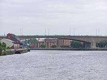
Kingston Bridge, Glasgow
| Kingston Bridge | |
|---|---|
 Kingston Bridge, looking eastward up the River Clyde. | |
| Coordinates | 55°51′19″N 4°16′12″W / 55.85528°N 4.27000°WCoordinates: 55°51′19″N 4°16′12″W / 55.85528°N 4.27000°W |
| Carries | Motor vehicles only (motorway bridge) |
| Crosses | River Clyde |
| Locale | Glasgow, United Kingdom |
| Official name | Kingston Bridge |
| Characteristics | |
| Design |
Balanced cantilever with triple-cell segmented prestressed concrete box girders Designer: William Fairhurst Contractor: Logan-Marples Ridgway |
| Width | Dual five-lane carriageway each carriageway: 21m (68ft) |
| Longest span | 143 m (470 ft) (side spans 62.5 m) |
| History | |
| Opened | 26 June 1970 |
| Statistics | |
| Daily traffic | 150,000 vehicles |
| Toll | Free |
The Kingston Bridge (Scots: Kingstoun Brig) is a balanced cantilever dual-span ten lane road bridge made of triple-cell segmented prestressed concrete box girders crossing the River Clyde in Glasgow, Scotland. The largest urban bridge in the United Kingdom, it carries the M8 motorway through the city centre. The Kingston Bridge is also one of the busiest road bridges in Europe, carrying around 150,000 vehicles every day.[1][2]
History
The name of the bridge referred to the erstwhile Kingston Dock which was located on the south bank of the river. It had been completed in 1867 between Windmillcroft Quay and the former headquarters of the Scottish Co-operative Wholesale Society on Morrison Street in Tradeston, adjacent to where the bridge now stands. It was Glasgow's first enclosed dock. The dock was eventually closed to navigation in 1966, when work began on the construction of the Kingston Bridge, and the basin was subsequently in-filled and apartments built on the site. At the time of construction however the Clyde Port Authority still insisted that the bridge have a clearance height of 18 m (60 ft) in order to allow dredgers to go upstream as far as the King George V Bridge. The bridge was designed by William Fairhurst and built by Logan-Marples Ridgway.
Location
The bridge connects Anderston and the city centre at Junction 18/19 with Tradeston and the Gorbals at Junction 20. The bridge consists of two parallel spans, each 21 m (68 ft) wide, with each supporting a five lane deck. The eastern span carrying southbound traffic and the western span carrying northbound traffic over the river. The approaches to the bridge are also linked with many junctions of their own, including major city centre ramps and the M77, that are two lanes wide. The outer spandrels of the bridge are clad with exposed-aggregate panels showing vertical joints.
Refurbishment
When opened by Queen Elizabeth the Queen Mother in 1970, the bridge was designed to handle 120,000 vehicles a day.[3] By 1990, the sheer excess volume and weight of traffic, combined with poor design and flaws in construction, resulted in serious structural deterioration being discovered in the bridge[4] A decade-long repair and renovation programme was initiated to repair and strengthen the bridge. These repairs have involved strengthening the quay walls and jacking-up the 52,000-tonne deck of the bridge, while still operational, to allow the construction of new supporting Piers, before lowering the bridge back onto the new, more robust supports. It was described by the contractor, Balfour Beatty, as one of the most ambitious civil engineering projects to take place in the city. Indeed, the operation involved 128 hydraulic jacks, making it the biggest ever bridge lift, qualifying for the Guinness Book of Records.[5]
A longer-term attempt to solve the problem of chronic congestion is the M74 northern extension, to act as the southern flank of the unbuilt Glasgow Inner Ring Road first planned in the 1960s. The existing "ski ramp" where the Inner Ring was intended to continue on has remained unused; the extended M74 meets the M8 secondary carriageways a few hundred yards further south at Scotland Street. This change of plan from the Scottish Executive was because of the Kingston Bridge's inability to handle an increase in traffic: the thinking was that the increased traffic from the new road will not then go straight over the bridge and will enable traffic from the south east, heading west to Ayrshire, Glasgow International Airport, Glasgow Prestwick Airport, or the docks at Greenock, Hunterston and Braehead, to bypass the Glasgow city centre section of the M8. At the Public Inquiry into the road scheme, critics countered that this would mean an increase in ground-level traffic in the Tradeston area as commuters attempt to gain access to the bridge's access ramps.[6] Prior to the M74 completion, a solution to the congestion problems has been the Clyde Arc or "Squinty Bridge", which opened in September 2006 – this route is expected to take at least some of the local short-distance traffic away from the Kingston. The M74 extension opened on 28 June 2011.
There is a dubious urban myth that the fourth man in the Williamwood bank robbery is buried in the pillars of the bridge. A long-exposure image of the bridge was also featured on the rear album cover of Deacon Blue's album, Raintown, as well as on the music video for the Simple Minds single Speed Your Love to Me.
Notes and references
- ↑ http://news.bbc.co.uk/1/hi/scotland/493793.stm BBC News article on the bridge reopening after remedial work
- ↑ http://www.scotland.gov.uk/Publications/2004/12/20446/48986 Scottish Government Tolled Bridges Review 2004
- ↑ http://vimeo.com/12634222
- ↑ http://findarticles.com/p/articles/mi_qa5379/is_/ai_n21482462 Report in Concrete magazine, Nov/Dec 2001
- ↑ Sunny Govan - Kingston Bridge overview
- ↑ http://www.scotland.gov.uk/Publications/2005/03/20752/53471 Report on objections made during public enquiry
External links
- Glasgow City Council page on Transport in Glasgow
- 'Chroma Streams: Tide and Traffic' - lighting art project
- Photograph of the Kingston Bridge in Glasgow
- Kingston Bridge at Structurae
| Next crossing upstream | River Clyde | Next crossing downstream |
| Tradeston Bridge | Kingston Bridge | Clyde Arc |