Kisvárda
| Kisvárda | ||
|---|---|---|
|
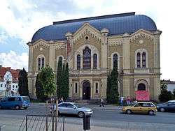
Rétköz Museum | ||
| ||
 Kisvárda | ||
| Coordinates: 48°13′N 22°05′E / 48.217°N 22.083°E | ||
| Country | Hungary | |
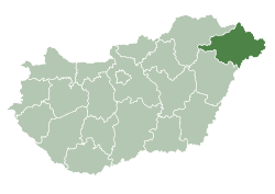
| County | Szabolcs-Szatmár-Bereg | |
| Area | ||
| • Total | 35.91 km2 (13.86 sq mi) | |
| Population (2012) | ||
| • Total | 16,473 | |
| • Density | 502.03/km2 (1,300.3/sq mi) | |
| Time zone | CET (UTC+1) | |
| • Summer (DST) | CEST (UTC+2) | |
| Postal code | 4600 | |
| Area code(s) | 45 | |
Kisvárda (pronounced [ˈkiʃvaːrdɒ]; German: Kleinwardein, Yiddish: קליינווארדיין Kleynvardeyn) is a town in Szabolcs-Szatmár-Bereg county, in the Northern Great Plain region of eastern Hungary near the border of Slovakia and Ukraine. It is the 3rd largest town in Szabolcs-Szatmár-Bereg after Nyíregyháza and Mátészalka with a population of 16 669 people. The Subregion of Kisvárda lies between two large landscapes, the Nyírség and the Rétköz. Kisvárda is just 22 km (14 mi) from the border of Ukraine, 30 km (18.6 mi) from Slovakia, 43.9 km (27.3 mi) from Nyíregyháza, 50 km (31 mi) from Ungvár (Uzhorod), 52.1 km (32.4 mi) from Beregszász (Berehove), 52.9 km (32.9 mi) from Sátoraljaújhely and 80 km (50 mi) from Dorolţ, Romania.
Etymology
The name of the town, which means "little castle" in Hungarian., dates back to the Conquest of Hungary. The conquering Hungarians named the town for its earthwork. In the Middle Ages, it occurred like Warda and Warada in documents. The "kis" (meaning little) word part was added to differentiate the town from Nagyvárad (now Oradea, Romania) with "nagy" (meaning great or large).
Coat of Arms
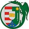
The red and white stripes on the shield symbolize the Árpád Dynasty, the medieval kings of Hungary. The sword with the Sun and green background shows the heroic knights of Kisvárda. The scales represents the town's trade and markets. In the middle of the shield there is the Castle of Kisvárda in gold. There is a winged dragon around the shield biting its tail. This is the insignia of the Order of the Dragon which derives from the Várday family's coat of arms.
History
The conquering Hungarians found a hill fort here in 895 which then they used for their border protection system.
St. Ladislaus defeated the Kuntesk Cuman prince and the Romanians [1] in 1085 in a great fight. In memory of the glorious battle, he had a church established. He dedicated it to St Peter and St Paul Apostles.
In the 12th century, the settlement's importance declined. The castle became the possession of the Swabian-Swedish Gutkeled family. The settlement was the denominator of one branch of the family, the Várdays. The Várday family worked a lot to revive Kisvárda. Shortly the place got their fair housing law.
Pelbárt Várady got permission from the king to build the Castle of Kisvárda in 1415.
In 1421, it became a town. István Várday, the Archbishop of Kalocsa, Matthias Corvinus's chancellor expended the town's autonomy in 1468. At that time, the population of Kisvárda was more than a thousand people. It became the centre of Szabolcs. The first guild was formed in 1591.
Because of the Turkish conquest of Hungary and the economic changes, the town's importance diminished.
Prior to World War II, Kisvárda had a large Jewish community that represented about 30 percent of the town's population. They were confined to a ghetto in 1944, and then deported to Auschwitz. The majority perished there. A small community was re-established after the war, but almost no Jews are left in Kisvárda today. The former synagogue, which remains one of the most imposing structures in Kisvárda, is now a local history museum known as the Rétközi Múzeum.
Economy
Historically, Kisvárda has been a market town for the surrounding agricultural district, and is also has some light industry such as distilling, electrics, and brake pad production. It is on the main railway line from the Hungarian capital of Budapest to Ukraine. Kisvárda also attracts tourists to its thermal springs, and the ruins of a medieval castle.
Notable People
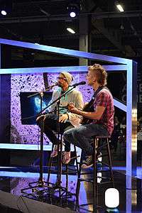
- ByeAlex, Hungarian singer, songwriter
- Gyula Halasy, Hungarian sport shooter
- Sándor Radó, Hungarian psychoanalyst
- Gabriella Juhász, Hungarian handballer
- Ivett Nagy, Hungarian handballer
- Victor Varconi, Hungarian filmstar who rose to fame in the silent era
- Moshe Grunwald Jewish Rabbi, progenitor of the Puppa Hasidic dynasty through his five sons
- Dov Gruner, Hungarian-born Zionist activist, member of the Irgun
- Shimon Sofer (II), Jewish Rabbi of the Hungarian city of Eger
- László Bódi, "Cipő", Hungarian singer, songwriter
- Bertalan Farkas, astronaut
International relations
Twin towns – Sister cities
Kisvárda is twinned with:
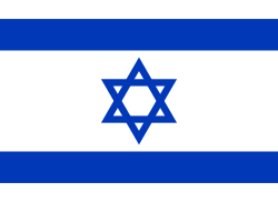 Karmiel, Israel
 Strzyżów, Poland
 Kráľovský Chlmec, Slovakia
 Hildburghausen, Germany
- Prien am Chiemsee, Germany
 Târgu Secuiesc, Romania
External links
- Official website
- Memorial Book of the Jews of Kisvarda and its Vicinity, Ed: Rabbi Dr. Karoly Jolesz, et al., Tel Aviv, Kleinwardein Society, 1980
References
- ↑ M. F. Dantine, C. Clémencet, U. Durant, F. Clement, G. Desprez, 1819 L'art de vérifier les dates des faits historiques, des chartes, des chroniques, et autres anciens monumens, 1819, p.51
Coordinates: 48°13′N 22°05′E / 48.217°N 22.083°E