Komaki Dam
| Komaki Dam | |
|---|---|
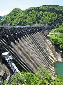 Downstream face | |
 Location of Komaki Dam in Japan | |
| Country | Japan |
| Location | Shogawa, Toyama Prefecture |
| Coordinates | 36°33′24″N 137°0′30″E / 36.55667°N 137.00833°ECoordinates: 36°33′24″N 137°0′30″E / 36.55667°N 137.00833°E |
| Purpose | Power |
| Status | Operational |
| Construction began | 1925 |
| Opening date | 1930 |
| Dam and spillways | |
| Type of dam | Arch gravity |
| Impounds | Shō River |
| Height | 79.2 m (260 ft) |
| Length | 300.8 m (987 ft) |
| Dam volume | 289,000 m3 (378,000 cu yd) |
| Spillway type | Crest overflow, 17 tainter gates |
| Reservoir | |
| Total capacity | 37,957,000 m3 (30,772 acre·ft) |
| Active capacity | 18,858,000 m3 (15,288 acre·ft) |
| Catchment area | 1,100 km2 (420 sq mi) |
| Surface area | 145 ha (360 acres) |
| Power station | |
| Operator(s) | Kansai Electric Power Co., Inc. |
| Commission date | 5 November 1930 |
| Hydraulic head | 68.46 m (224.6 ft) |
| Turbines | 4 x 22.55 MW Francis-type |
| Installed capacity | 90.2 MW[1] |
The Komaki Dam is an arch-gravity dam on the Shō River about 2.5 km (1.6 mi) southeast of Shogawa in Toyama Prefecture, Japan. It was constructed between 1925 and 1930. The dam has an associated 90.2 MW hydroelectric power station which was commissioned in 1930. Of the nine dams on the Shō River it is the second furthest downstream.[2]
See also
- Shogawa Goguchi Dam – downstream
- Soyama Dam – upstream
References
- ↑ "Kansai Electric Power Komaki power plant" (in Japanese). Suiryoku. Retrieved 15 July 2013.
- ↑ "Komaki dam" (in Japanese). Japan Dam Handbook. Retrieved 15 July 2013.
| Wikimedia Commons has media related to Komaki Dam. |
This article is issued from Wikipedia - version of the 11/19/2015. The text is available under the Creative Commons Attribution/Share Alike but additional terms may apply for the media files.