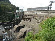
Wadagawa Dam
| Wadagawa Dam | |
|---|---|
 | |
 Location of Wadagawa Dam in Japan | |
| Country | Japan |
| Location | Tonami, Toyama Prefecture |
| Coordinates | 36°39′16.6″N 137°2′22.29″E / 36.654611°N 137.0395250°ECoordinates: 36°39′16.6″N 137°2′22.29″E / 36.654611°N 137.0395250°E |
| Purpose | Irrigation, flood control, power |
| Status | Operational |
| Construction began | 1962 |
| Opening date | 1967 |
| Owner(s) | Toyama Prefecture |
| Dam and spillways | |
| Type of dam | Gravity |
| Impounds | Wadagawa River |
| Height | 21 m (69 ft) |
| Length | 137 m (449 ft) |
| Dam volume | 23,000 m3 (30,000 cu yd) |
| Reservoir | |
| Total capacity | 3,070,000 m3 (2,490 acre·ft) |
| Active capacity | 1,900,000 m3 (1,500 acre·ft) |
| Power station | |
| Commission date | December 1968 |
| Hydraulic head | 18.15 m (59.5 ft) |
| Turbines | 2 x 3.7 MW Kaplan-type |
| Installed capacity | 7.4 MW |
| Annual generation | 40 GWh[1] |
The Wadagawa Dam is a gravity dam on the Wadagawa River (a tributary of the Shō River) in Tonami, Toyama Prefecture, Japan. It was constructed between 1962 and 1967. The dam has an associated 7.4 MW hydroelectric power station which was commissioned in 1968. Of the dams in the Shō River system, it is the furthest downstream.[2]
See also
- Shogawa Goguchi Dam – first, and furthest downstream, of nine dams on the Shō River main stem
References
- ↑ "Zhuang east second power plant" (in Japanese). Toyama Prefectural Office. Retrieved 15 July 2013.
- ↑ "Wadagawa Dam" (in Japanese). Japan Dam Handbook. Retrieved 15 July 2013.
This article is issued from Wikipedia - version of the 9/28/2015. The text is available under the Creative Commons Attribution/Share Alike but additional terms may apply for the media files.