Senzoku Dam
| Senzoku Dam | |
|---|---|
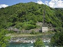 Togagawa II Power Station on the Shō River | |
 Location of Senzoku Dam in Japan | |
| Country | Japan |
| Location | Toyama Prefecture |
| Coordinates | 36°23′10.36″N 136°59′26.43″E / 36.3862111°N 136.9906750°ECoordinates: 36°23′10.36″N 136°59′26.43″E / 36.3862111°N 136.9906750°E |
| Purpose | Power |
| Status | Operational |
| Opening date | 1974 |
| Dam and spillways | |
| Type of dam | Gravity |
| Impounds | Togagawa River |
| Height | 33.5 m (110 ft) |
| Length | 143 m (469 ft) |
| Dam volume | 8,000 m3 (10,000 cu yd) |
| Spillway type | Crest overflow, one tainter gate |
| Reservoir | |
| Total capacity | 132,000 m3 (107 acre·ft) |
| Active capacity | 132,000 m3 (107 acre·ft) |
| Catchment area | 66.2 km2 (25.6 sq mi) |
| Normal elevation | 614 m (2,014 ft) |
| Power station | |
| Name | Togagawa II Power Station |
| Coordinates | 36°25′16″N 136°56′16″E / 36.42111°N 136.93778°E |
| Operator(s) | Kansai Electric Power Co., Inc. |
| Commission date | 8 December 1973 |
| Hydraulic head | 338.73 m (1,111.3 ft) |
| Turbines | 1 x 32.7 MW Francis-type |
| Installed capacity | 32.7 MW |
The Senzoku Dam is a gravity dam on the Togagawa River (a tributary of the Shō River) about 20 km (12 mi) south of Shogawa in Toyama Prefecture, Japan. It was completed in 1974. The dam sends water to the 32.7 MW Togagawa II hydroelectric power station 5.7 km (3.5 mi) to the west on the Shō River. It was commissioned in 1973.[1]
See also
- Toga Dam – downstream
- Togagawa Dam – upstream
References
- ↑ "Kansai Electric Power Togagawa 2 power plant" (in Japanese). Suiryoku. Retrieved 15 July 2013.
This article is issued from Wikipedia - version of the 11/19/2015. The text is available under the Creative Commons Attribution/Share Alike but additional terms may apply for the media files.