Shogawa Goguchi Dam
| Shogawa Goguchi Dam | |
|---|---|
 | |
 Location of Shogawa Goguchi Dam in Japan | |
| Country | Japan |
| Location | Shogawa, Toyama Prefecture |
| Coordinates | 36°34′30.67″N 136°59′44.42″E / 36.5751861°N 136.9956722°ECoordinates: 36°34′30.67″N 136°59′44.42″E / 36.5751861°N 136.9956722°E |
| Purpose | Irrigation, flood control, power |
| Status | Operational |
| Construction began | 1934 |
| Opening date | 1939 |
| Dam and spillways | |
| Type of dam | Gravity |
| Impounds | Shō River |
| Height | 18.5 m (61 ft) |
| Length | 103.3 m (339 ft) |
| Dam volume | 20,000 m3 (26,000 cu yd) |
| Reservoir | |
| Total capacity | 626,000 m3 (508 acre·ft) |
| Active capacity | 405,000 m3 (328 acre·ft) |
| Catchment area | 1,113 km2 (430 sq mi) |
| Surface area | 16 ha (40 acres) |
| Power station | |
| Operator(s) | Kansai Electric Power Co., Inc. |
| Commission date |
Stage I: 13 December 1939 Stage II: 24 March 1967 |
| Hydraulic head |
Stage I: 17.66 m (57.9 ft) Stage II: 18.22 m (59.8 ft) |
| Turbines |
Stage I: 2 x 4.2 MW Kaplan-type Stage II: 1 x 15 MW Kaplan-type |
| Installed capacity | 23.4 MW[1][2] |
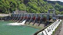
The Shogawa Goguchi Dam is a gravity dam on the Shō River in Shogawa, Toyama Prefecture, Japan. It was constructed between 1934 and 1939. The dam has an associated 23.4 MW hydroelectric power station which was commissioned in two stages, December 1939 and March 1967. Of the nine dams on the Shō River it is the furthest downstream.[3]
See also
- Wadagawa Dam – downstream on a tributary of the Shō River
References
- ↑ "Kansai Electric Power Nakano power plant" (in Japanese). Suiryoku. Retrieved 15 July 2013.
- ↑ "Kansai Electric Power male god power plant" (in Japanese). Suiryoku. Retrieved 15 July 2013.
- ↑ "Shogawa dam abutment" (in Japanese). Japan Dam Handbook. Retrieved 15 July 2013.
| Wikimedia Commons has media related to Shogawa Goguchi Dam. |
This article is issued from Wikipedia - version of the 11/19/2015. The text is available under the Creative Commons Attribution/Share Alike but additional terms may apply for the media files.