Korydallos
| Korydallos Κορυδαλλός | |
|---|---|
 | |
 Korydallos | |
|
Location within the region | |
| Coordinates: 37°59′N 23°39′E / 37.983°N 23.650°ECoordinates: 37°59′N 23°39′E / 37.983°N 23.650°E | |
| Country | Greece |
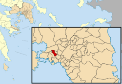
| Administrative region | Attica |
| Regional unit | Piraeus |
| Government | |
| • Mayor | Stavros Kasimatis |
| Area | |
| • Municipality | 4.324 km2 (1.670 sq mi) |
| Elevation | 30 m (100 ft) |
| Population (2011)[1] | |
| • Municipality | 63,445 |
| • Municipality density | 15,000/km2 (38,000/sq mi) |
| Time zone | EET (UTC+2) |
| • Summer (DST) | EEST (UTC+3) |
| Postal code | 181 xx |
| Area code(s) | 210 |
| Vehicle registration | Z |
| Website | www.korydallos.gr |
Korydallos (Greek: Κορυδαλλός;[2] Latin: Corydallus) is a municipality in the Piraeus regional unit, Greece. It is a northern suburb of Piraeus.
Geography
Korydallos is situated southeast of the mountain Aegaleo. It is located 7 km west of central Athens and 3 km north of Piraeus. The municipality has an area of 4.324 km2.[3] The main street Taxiarchon has become a well known shopping center with many fashion shops and boutiques.
History
Korydallos was founded in ancient times, and was one of the 100 municipalities in ancient Attica at the end of the 6th century BC. Theophilos Corydalleus (1563–1646) was a philosopher who lived in Corydallos. 200 years later, Korydallos was known as Koutsoukari after the property owner of the greater area, Emmanouil Koutsikaris. After that it was renamed into Pachy after the next owner (Pachinas). In 1923, the town was renamed back into its ancient name, Korydallos. The population in 1928 was 2,500. Korydallos was part of the municipality of Piraeus until 1934, when it became a separate community. It was elevated to municipality status in 1946.[4] The city now boasts a population of 63,000.
Historical population
| Year | Municipality |
|---|---|
| 1981 | 61,313 |
| 1991 | 63,184 |
| 2001 | 67,456 |
| 2011 | 63,445 |
Football teams
- Aetos Korydallou
- Kypros Korydallou
- Thuella Korydallou
- Ermis Korydallou
See also
References
- ↑ "Απογραφή Πληθυσμού - Κατοικιών 2011. ΜΟΝΙΜΟΣ Πληθυσμός" (in Greek). Hellenic Statistical Authority.
- ↑ Known as Παχύ, Pachy from the 1860s till 1923.
- ↑ "Population & housing census 2001 (incl. area and average elevation)" (PDF) (in Greek). National Statistical Service of Greece.
- ↑ EETAA local government changes
External links
- Official website (Greek)
- Map Korydallos (Greek)
- blog of Korydallos (in Greek)
- Weather conditions in Korydallos
 |
Chaidari | Agia Varvara | | |
| Nikaia | |
|||
| ||||
| | ||||
| Nikaia | Nikaia |
Administrative division of the Attica Region | ||
|---|---|---|
| Regional unit of Central Athens | 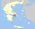 | |
| Regional unit of North Athens | ||
| Regional unit of West Athens | ||
| Regional unit of South Athens | ||
| Regional unit of Piraeus | ||
| Regional unit of East Attica | ||
| Regional unit of West Attica | ||
| Regional unit of Islands | ||
| ||