Metamorfosi
For other uses of "Metamorfosi" and "Metamorfosis", see Metamorfosis (disambiguation).
| Metamorfosi Μεταμόρφωση | |
|---|---|
 | |
 Metamorfosi | |
|
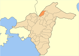
Location within the region 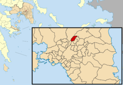 | |
| Coordinates: 38°3′N 23°45′E / 38.050°N 23.750°ECoordinates: 38°3′N 23°45′E / 38.050°N 23.750°E | |
| Country | Greece |
| Administrative region | Attica |
| Regional unit | North Athens |
| Government | |
| • Mayor | Miltiadis Karpetas (PASOK) |
| Area | |
| • Municipality | 5.502 km2 (2.124 sq mi) |
| Elevation | 170 m (560 ft) |
| Population (2011)[1] | |
| • Municipality | 29,891 |
| • Municipality density | 5,400/km2 (14,000/sq mi) |
| Time zone | EET (UTC+2) |
| • Summer (DST) | EEST (UTC+3) |
| Postal code | 144 5x |
| Area code(s) | 210 |
| Vehicle registration | Z |
| Website | www.metamorfossi.gr |
Metamorfosi (Greek: Μεταμόρφωση, which means "transfiguration", before 1957: Κουκουβάουνες - Koukouvaounes[2]) is a suburb in the northern part of the Athens agglomeration, Greece, and a municipality of the Attica region.
Geography
Metamorfosi is situated east of the small river Kifisos, 9 km north of Athens city centre. The municipality has an area of 5.502 km2.[3] The built-up area of Metamorfosi is continuous with those of the neighbouring suburbs Lykovrysi, Irakleio and Nea Filadelfeia. Motorway 1 and Motorway 6 intersect in Metamorfosi. The town is served by a Proastiakos suburban railway station.
Historical population
| Year | Population |
|---|---|
| 1981 | 17,840 |
| 1991 | 21,052 |
| 2001 | 26,448 |
| 2011 | 29,891 |
See also
References
- ↑ "Απογραφή Πληθυσμού - Κατοικιών 2011. ΜΟΝΙΜΟΣ Πληθυσμός" (in Greek). Hellenic Statistical Authority.
- ↑ Name changes of settlements in Greece
- ↑ "Population & housing census 2001 (incl. area and average elevation)" (PDF) (in Greek). National Statistical Service of Greece.
External links
| Wikimedia Commons has media related to Metamorfosi. |
 |
Acharnes | Kifisia | | |
| Acharnes | |
Lykovrysi | ||
| ||||
| | ||||
| Nea Filadelfeia | Irakleio | Irakleio |
Administrative division of the Attica Region | ||
|---|---|---|
| Regional unit of Central Athens | 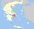 | |
| Regional unit of North Athens | ||
| Regional unit of West Athens | ||
| Regional unit of South Athens | ||
| Regional unit of Piraeus | ||
| Regional unit of East Attica | ||
| Regional unit of West Attica | ||
| Regional unit of Islands | ||
| ||
This article is issued from Wikipedia - version of the 11/7/2016. The text is available under the Creative Commons Attribution/Share Alike but additional terms may apply for the media files.