Kursk Oblast
| Kursk Oblast Курская область (Russian) | |||
|---|---|---|---|
| — Oblast — | |||
| |||
|
| |||
| |||
|
| |||
| Political status | |||
| Country | Russia | ||
| Federal district | Central[2] | ||
| Economic region | Central Black Earth[3] | ||
| Established | June 13, 1934[4] | ||
| Administrative center | Kursk[5] | ||
| Government (as of November 2015) | |||
| • Governor[6] | Alexander Mikhaylov | ||
| • Legislature | Oblast Duma[6] | ||
| Statistics | |||
| Area (as of the 2002 Census)[7] | |||
| • Total | 29,800 km2 (11,500 sq mi) | ||
| Area rank | 65th | ||
| Population (2010 Census)[8] | |||
| • Total | 1,127,081 | ||
| • Rank | 46th | ||
| • Density[9] | 37.82/km2 (98.0/sq mi) | ||
| • Urban | 65.2% | ||
| • Rural | 34.8% | ||
| Population (January 2015 est.) | |||
| • Total | 1,117,378[10] | ||
| Time zone(s) | MSK (UTC+03:00)[11] | ||
| ISO 3166-2 | RU-KRS | ||
| License plates | 46 | ||
| Official languages | Russian[12] | ||
| Official website | |||
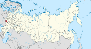
Kursk Oblast (Russian: Курская область, tr. Kurskaya oblast; IPA: [ˈkurskəjə ˈobləsʲtʲ]) is a federal subject of Russia (an oblast). Its administrative center is the city of Kursk. Population: 1,127,081 (2010 Census).[8]
Geography
The oblast occupies the southern slopes of the middle-Russian plateau, and its average elevation is from 177 to 225 meters (580–738 ft). The surface is hilly, and intersected by ravines. The central part of Kursk oblast is more elevated than the Seym Valley to the west. The Timsko-Shchigrinsky ridge contains the highest point in the oblast at 288 meters (945 ft) above the sea level. The low relief, gentler slopes, and mild winter make the area suitable for farming, and much of the forest has been cleared.
The chernozem soils cover around 70% of the oblast's territory; podsol soils cover 26%.
- Borders:
- internal: Bryansk Oblast (NW) (border line length: 120 km), Oryol Oblast (N, 325 km), Lipetsk Oblast (NE, 65 km), Voronezh Oblast (E, 145 km), Belgorod Oblast (S, 335 km)
- international: Sumy Oblast of Ukraine (W, 245 km)
- highest point: 288 m
Rivers
Kursk Oblast contributes to two major drainage areas—the Dnieper River and the Don River (78% and 22% respectively). There are 902 rivers and streams in the oblast, with their total length of approximately 8,000 kilometers (5,000 mi). Major rivers are the Seym and the Psyol.
Lakes
The inland waters of Kursk oblast consist of 145 artificial lakes and about 550 small ponds.
Natural resources

Kursk Oblast is one of the nation's major producers of iron ore. The area of Kursk Magnetic Anomaly has one of the richest iron ore deposits in the world. Also, rare-earth and base metals occur in commercial quantities in several locations. Refractory loam, mineral sands, and chalk are quarried and processed in the region. Oblast's sufficient reserves of artesian well water are proving useful for medical purposes.
Climate
The oblast's location at the center of the European part of Russia gives the region a medium continental climate: warm summers and relatively mild winters. In July, the average daytime high temperature is +19.3 °C (66.7 °F). In January the average high is −8.6 °C (16.5 °F). The average number of frost-free days ranges from 150 in the north to 160 in the south. The growing season in Kursk Oblast varies, from 180 days in the north to 195 days in the southwest. The average annual precipitation for the oblast is 584 millimeters (23.0 in), but it ranges from 634 millimeters (25.0 in) in the northwest, to about 500 millimeters (20 in) or less in the southeastern corner. The maximum of the rain falls during June and July. The snow depth in Kursk Oblast differs considerably, from 300–400 mm (12–16 in) in the north of the oblast, to 150–250 mm (6–10 in) in the south. Annual sunshine is 1,775 hours.
Flora and fauna
Kursk Oblast is a part of the Eastern European forest-steppe. One-quarter of Kursk oblast was once heavily wooded. Hardwood timbers included oak, ash, and elm. Now forests cover only 10% of the oblast. Animals native to the area are numerous. Pike, bleak, and perch are abundant in local rivers. Otter and badger, as well as wild boar, red deer, and Roe Deer remain numerous in many parts of the area.
Administrative divisions
Demographics
Population: 1,127,081 (2010 Census);[8] 1,235,091 (2002 Census);[13] 1,339,414 (1989 Census).[14]
- 2012
2009 - 1.53 | 2010 - 1.55 | 2011 - 1.61 | 2012 - 1.70 | 2013 - 1.67 | 2014 - 1.70 | 2015 - 1.72(e)
Ethnic composition (2010):[8]
- Russians - 96.5%
- Ukrainians - 1.3%
- Armenians - 0.5%
- Others - 1.7%
- 52,722 people were registered from administrative databases, and could not declare an ethnicity. It is estimated that the proportion of ethnicities in this group is the same as that of the declared group.[17]
The annual growth rate of the oblast's population is negative; death rate exceeds overall birth rates and immigration.
Religion

According to a 2012 official survey[18] 68.7% of the population of Kursk Oblast adheres to the Russian Orthodox Church. In addition, 24% of the population declares to be "spiritual but not religious", 4% is atheist, and 3.3% follows other religions or did not give an answer to the question.[18]
History
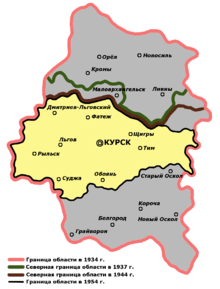
Although territory of Kursk Oblast had been populated since the end of the last Ice Age, information about the area was scanty until 1596 when the Kursk stronghold was built. A real growth of the area around Kursk began soon after that, with a large migration from Central Russia after famine in the beginning of the 17th century. Between 1708 and 1719, Kursk was a part of the newly created Kiev Governorate. From 1719 to 1727 it was a part of Belgorod province of Kiev Governorate. Later Kursk uyezd was a part of Belgorod Governorate. On May 23, 1779, Kursk Governorate was established. The latter subdivision existed until 1928, when the territory of Kursk Governorate became a part of Central Black Earth Oblast. As Central Chernozem Oblast was very large its administration was very difficult, on June 13, 1934 it was divided into two oblasts: Kursk Oblast and Voronezh Oblast. In the period between 1934 and 1954, oblasts' borders were frequently adjusted. However, the area and borders of the oblast have remained stable from 1954.
During World War II, the territory of Kursk Oblast was occupied by the German troops from fall of 1941 until summer of 1943. The Battle of Kursk, which was one of the major battles of World War II, took place in the region between July 5 and August 23, 1943.
Politics
During the Soviet period, the high authority in the oblast was shared between three persons: The first secretary of the Kursk CPSU Committee (who in reality had the biggest authority), the chairman of the oblast Soviet (legislative power), and the Chairman of the oblast Executive Committee (executive power). Since 1991, CPSU lost all the power, and the head of the Oblast administration, and eventually the governor was appointed/elected alongside elected regional parliament.
The Charter of Kursk Oblast is the fundamental law of the region. The Kursk Oblast Duma is the province's standing legislative (representative) body. The Legislative Assembly exercises its authority by passing laws, resolutions, and other legal acts and by supervising the implementation and observance of the laws and other legal acts passed by it. The highest executive body is the Oblast Government, which includes territorial executive bodies such as district administrations, committees, and commissions that facilitate development and run the day to day matters of the province. The Oblast administration supports the activities of the Governor who is the highest official and acts as guarantor of the observance of the oblast Charter in accordance with the Constitution of Russia.
The center-right pro-government United Russia Party and the left Communist Party of the Russian Federation are Kursk Oblast's major political parties. Traditionally, the Communist Party is the strongest in the Oblast's rural area.
Economy
Industry
The oblast's industrial production dropped rapidly during the 1990s, as an industrial crisis was stimulated by the nationwide economic crisis which followed the collapse of the Soviet Union. However, by the end of the decade output was increasing. Moreover, the manufacturing sector, despite a sagging economy in the late 20th century, continues to account for about 40% of the oblast's GDP. The engineering, electric-power, metal-working, chemicals, and food processing are the dominant industries.
Agriculture
Most of the main farming areas are used for natural pastures or cultivation, which involves mainly wheat, sugar beet, and fodder crops. The main categories of productive holdings are wheat farms, dairy farms, poultry farms, and beef cattle. Agricultural lands cover 23,000 square kilometers (8,900 sq mi), or 77% of the oblast's territory.
Transportation
Transportation industry of Kursk Oblast, with easy access to national and international markets, is the basis for the oblast's development. The most important modes of transport throughout the oblast are by railway and road. Total length of railway network is 1,100 kilometers (680 mi). Two major rail links pass through Kursk Oblast: Moscow–Kharkiv and Kiev–Voronezh. Region roads serve all towns and rural settlements through 5,600 kilometers (3,500 mi) road network. In addition, there is an airport in the oblast which was opened to international flights in July 1997.
Railroads
Railroads are one on the most important component parts of the transportation system in the oblast. There is a total of sixty-five railway stations in the oblast. The operational length of the railways is 1,561.2 kilometers (970.1 mi), of which 500 kilometers (310 mi) are access roads. The length of the electrified lines is 242 kilometers (150 mi). The density of the railroads in Kursk Oblast is one of the highest in Russia. The largest railway junctions are Kursk, Lgov, and Kastornoye. Oblast's railroads are a part of the Moscow and South Eastern Railway systems.
Education

The largest universities of Kursk Oblast is Kursk State University, Kursk State Technical University, Kursk State Medical University and Kursk State Agricultural Academy which are located in the city of Kursk. There are also 19 other higher education facilities in Kursk Oblast.
Tourism
Kursk Oblast's natural attraction is the Central Black Earth Nature Reserve, which offers great opportunity for hiking. Oblast's forests and others undeveloped areas are ideal for hunting, fishing, and camping. Traditional art and architecture are preserved in the town-museum of Rylsk and others historical towns of Kursk Oblast.
See also
References
Notes
- ↑ Article 1 of the Charter of Kursk Oblast states that the symbols of the oblast include a flag and a coat of arms, but not an anthem.
- ↑ Президент Российской Федерации. Указ №849 от 13 мая 2000 г. «О полномочном представителе Президента Российской Федерации в федеральном округе». Вступил в силу 13 мая 2000 г. Опубликован: "Собрание законодательства РФ", №20, ст. 2112, 15 мая 2000 г. (President of the Russian Federation. Decree #849 of May 13, 2000 On the Plenipotentiary Representative of the President of the Russian Federation in a Federal District. Effective as of May 13, 2000.).
- ↑ Госстандарт Российской Федерации. №ОК 024-95 27 декабря 1995 г. «Общероссийский классификатор экономических регионов. 2. Экономические районы», в ред. Изменения №5/2001 ОКЭР. (Gosstandart of the Russian Federation. #OK 024-95 December 27, 1995 Russian Classification of Economic Regions. 2. Economic Regions, as amended by the Amendment #5/2001 OKER. ).
- ↑ Resolution of June 13, 1934
- ↑ Charter of Kursk Oblast, Article 8
- 1 2 Charter, Article 12
- ↑ Федеральная служба государственной статистики (Federal State Statistics Service) (2004-05-21). "Территория, число районов, населённых пунктов и сельских администраций по субъектам Российской Федерации (Territory, Number of Districts, Inhabited Localities, and Rural Administration by Federal Subjects of the Russian Federation)". Всероссийская перепись населения 2002 года (All-Russia Population Census of 2002) (in Russian). Federal State Statistics Service. Retrieved 2011-11-01.
- 1 2 3 4 Russian Federal State Statistics Service (2011). "Всероссийская перепись населения 2010 года. Том 1" [2010 All-Russian Population Census, vol. 1]. Всероссийская перепись населения 2010 года (2010 All-Russia Population Census) (in Russian). Federal State Statistics Service. Retrieved June 29, 2012.
- ↑ The density value was calculated by dividing the population reported by the 2010 Census by the area shown in the "Area" field. Please note that this value may not be accurate as the area specified in the infobox is not necessarily reported for the same year as the population.
- ↑ Kursk Oblast Territorial Branch of the Federal State Statistics Service. Численность населения (на начало года) (Russian)
- ↑ Правительство Российской Федерации. Федеральный закон №107-ФЗ от 3 июня 2011 г. «Об исчислении времени», в ред. Федерального закона №271-ФЗ от 03 июля 2016 г. «О внесении изменений в Федеральный закон "Об исчислении времени"». Вступил в силу по истечении шестидесяти дней после дня официального опубликования (6 августа 2011 г.). Опубликован: "Российская газета", №120, 6 июня 2011 г. (Government of the Russian Federation. Federal Law #107-FZ of June 31, 2011 On Calculating Time, as amended by the Federal Law #271-FZ of July 03, 2016 On Amending Federal Law "On Calculating Time". Effective as of after sixty days following the day of the official publication.).
- ↑ Official on the whole territory of Russia according to Article 68.1 of the Constitution of Russia.
- ↑ Russian Federal State Statistics Service (May 21, 2004). "Численность населения России, субъектов Российской Федерации в составе федеральных округов, районов, городских поселений, сельских населённых пунктов – районных центров и сельских населённых пунктов с населением 3 тысячи и более человек" [Population of Russia, Its Federal Districts, Federal Subjects, Districts, Urban Localities, Rural Localities—Administrative Centers, and Rural Localities with Population of Over 3,000] (XLS). Всероссийская перепись населения 2002 года [All-Russia Population Census of 2002] (in Russian). Retrieved August 9, 2014.
- ↑ Demoscope Weekly (1989). "Всесоюзная перепись населения 1989 г. Численность наличного населения союзных и автономных республик, автономных областей и округов, краёв, областей, районов, городских поселений и сёл-райцентров" [All Union Population Census of 1989: Present Population of Union and Autonomous Republics, Autonomous Oblasts and Okrugs, Krais, Oblasts, Districts, Urban Settlements, and Villages Serving as District Administrative Centers]. Всесоюзная перепись населения 1989 года [All-Union Population Census of 1989] (in Russian). Институт демографии Национального исследовательского университета: Высшая школа экономики [Institute of Demography at the National Research University: Higher School of Economics]. Retrieved August 9, 2014.
- ↑ http://www.gks.ru/free_doc/2012/demo/edn12-12.htm
- ↑ http://www.gks.ru/wps/wcm/connect/rosstat_main/rosstat/ru/statistics/publications/catalog/doc_1137674209312
- ↑ http://www.perepis-2010.ru/news/detail.php?ID=6936
- 1 2 3 Arena - Atlas of Religions and Nationalities in Russia. Sreda.org
- ↑ 2012 Survey Maps. "Ogonek", № 34 (5243), August 27, 2012. Retrieved September 24, 2012.
Sources
- Курская областная Дума. Закон №67-ЗКО от 2 октября 2001 г. «Устав Курской области», в ред. Закона №30-ЗКО от 28 апреля 2015 г. «О внесении изменения в абзац второй части 3 статьи 23 Устава Курской области». Вступил в силу со дня официального публикования. Опубликован: "Курская правда", №161, 5 октября 2001 г. (Kursk Oblast Duma. Law #67-ZKO of October 2, 2001 Charter of Kursk Oblast, as amended by the Law #30-ZKO of April 28, 2015 On Amending Paragraph Two of Part 3 of Article 23 of the Charter of Kursk Oblast. Effective as of the official publication date.).
- Всероссийский центральный исполнительный комитет. Постановление от 13 июня 1934 г. «О разделении Центрально-Чернозёмной области». (All-Russian Central Executive Committee. Resolution of June 13, 1934 On Splitting Central Black Earth Oblast. ).
External links
| Wikimedia Commons has media related to Kursk Oblast. |
- Official website of Kursk Oblast
- Official website of Kursk Oblast (Russian)
- Kursk Region History and General Information
 |
|
|
|
|
| |
|
| ||
| ||||
| | ||||
| |
| |||||||||||||||||||||||||||||||
| |||||||||||||||||||||||||||||||