Lake Mills, Wisconsin
| Lake Mills, Wisconsin | |
|---|---|
| City | |
|
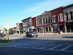
Downtown Lake Mills, east of the intersection of Lake and Main streets | |
 Lake Mills, Wisconsin Location of Lake Mills within Wisconsin | |
| Coordinates: 43°4′48″N 88°54′33″W / 43.08000°N 88.90917°WCoordinates: 43°4′48″N 88°54′33″W / 43.08000°N 88.90917°W | |
| Country | United States |
| State | Wisconsin |
| County | Jefferson |
| Government | |
| • Type | City Council |
| Area[1] | |
| • Total | 4.44 sq mi (11.50 km2) |
| • Land | 4.06 sq mi (10.52 km2) |
| • Water | 0.38 sq mi (0.98 km2) |
| Population (2010)[2] | |
| • Total | 5,708 |
| • Estimate (2012[3]) | 5,783 |
| • Density | 1,405.9/sq mi (542.8/km2) |
| Time zone | Central (CST) (UTC-6) |
| • Summer (DST) | CDT (UTC-5) |
| Area code(s) | 920 |
| Website |
www |
Lake Mills is a city in Jefferson County, Wisconsin, United States. The population was 5,708 at the 2010 census.[4] The city is located partially within the Town of Lake Mills.
History
The area was first settled by Captain Joseph Keyes. He called it "Lake Mills", after a saw mill and grist mill operating using power from nearby Rock Lake.[5][6]
Lake Mills was chartered in 1836, and the first building was built in 1837. Lake Mills occupies the east shore of Rock Lake. The village of Lake Mills incorporated in 1852 out of the surrounding town of Lake Mills. In 1866 the village changed its name to "Tyrahnena", but changed it back again to "Lake Mills" the next year.[7][8] (Tyrahnena, or Tyranena, is supposedly an indigenous name meaning "sparkling waters".)[9]
Geography
Lake Mills is located at 43°4′48″N 88°54′33″W / 43.08000°N 88.90917°W (43.080108, -88.909209).[10]
According to the United States Census Bureau, the city has a total area of 4.44 square miles (11.50 km2), of which 4.06 square miles (10.52 km2) is land and 0.38 square miles (0.98 km2) is water.[1]
Demographics
| Historical population | |||
|---|---|---|---|
| Census | Pop. | %± | |
| 1870 | 590 | — | |
| 1880 | 671 | 13.7% | |
| 1890 | 1,053 | 56.9% | |
| 1900 | 1,387 | 31.7% | |
| 1910 | 1,672 | 20.5% | |
| 1920 | 1,754 | 4.9% | |
| 1930 | 2,007 | 14.4% | |
| 1940 | 2,219 | 10.6% | |
| 1950 | 2,516 | 13.4% | |
| 1960 | 2,951 | 17.3% | |
| 1970 | 3,556 | 20.5% | |
| 1980 | 3,670 | 3.2% | |
| 1990 | 4,143 | 12.9% | |
| 2000 | 4,843 | 16.9% | |
| 2010 | 5,708 | 17.9% | |
| Est. 2015 | 5,798 | [11] | 1.6% |

2010 census
As of the census[2] of 2010, there were 5,708 people, 2,319 households, and 1,503 families residing in the city. The population density was 1,405.9 inhabitants per square mile (542.8/km2). There were 2,776 housing units at an average density of 683.7 per square mile (264.0/km2). The racial makeup of the city was 96.1% White, 0.7% African American, 0.2% Native American, 0.5% Asian, 1.2% from other races, and 1.3% from two or more races. Hispanic or Latino of any race were 3.8% of the population.
There were 2,319 households of which 32.4% had children under the age of 18 living with them, 52.4% were married couples living together, 8.7% had a female householder with no husband present, 3.7% had a male householder with no wife present, and 35.2% were non-families. 28.2% of all households were made up of individuals and 11.6% had someone living alone who was 65 years of age or older. The average household size was 2.42 and the average family size was 3.00.
The median age in the city was 37.2 years. 24.9% of residents were under the age of 18; 7% were between the ages of 18 and 24; 28.8% were from 25 to 44; 25.7% were from 45 to 64; and 13.5% were 65 years of age or older. The gender makeup of the city was 48.8% male and 51.2% female.
2000 census
As of the census[13] of 2000, there were 4,843 people, 1,924 households, and 1,289 families residing in the city. The population density was 1,415.6 people per square mile (546.8/km²). There were 2,065 housing units at an average density of 603.6 per square mile (233.1/km²). The racial makeup of the city was 97.54% White, 0.17% Black or African American, 0.25% Native American, 0.87% Asian, 0.41% from other races, and 0.76% from two or more races. 2.33% of the population were Hispanic or Latino of any race.
There were 1,924 households out of which 33.8% had children under the age of 18 living with them, 56.0% were married couples living together, 8.0% had a female householder with no husband present, and 33.0% were non-families. 26.8% of all households were made up of individuals and 13.0% had someone living alone who was 65 years of age or older. The average household size was 2.49 and the average family size was 3.05.
In the city the population was spread out with 27.2% under the age of 18, 6.6% from 18 to 24, 31.0% from 25 to 44, 20.8% from 45 to 64, and 14.5% who were 65 years of age or older. The median age was 36 years. For every 100 females there were 92.9 males. For every 100 females age 18 and over, there were 91.1 males.
The median income for a household in the city was $44,132, and the median income for a family was $54,131. Males had a median income of $36,394 versus $24,635 for females. The per capita income for the city was $21,929. About 5.3% of families and 7.3% of the population were below the poverty line, including 8.9% of those under age 18 and 6.1% of those age 65 or over.
Economy
- Ephraim Faience Pottery
- Lewis Station Winery
- Obsession Telescopes
- Tyranena Brewing
Media
Lake Mills is home to a weekly newspaper, The Lake Mills Leader.
Notable people
- Mel J. Cyrak, Wisconsin state assemblyman
- Palmer F. Daugs, Wisconsin state assemblyman
- Ernst F. Detterer, artist
- Nelson H. Falk, Wisconsin state assemblyman
- William Everson, Wisconsin state assemblyman
- Charles Greenwood, Wisconsin State Assemblyman
- Carleton Bruns Joeckel, librarian, author, and advocate for public libraries
- Theodore S. Jones, Wisconsin state assemblyman
- Louis Wescott Myers, Chief Justice of the California Supreme Court
- Charles Phillips, Wisconsin state assemblyman
- Hal Raether, MLB pitcher
- Jim Wilson, Oklahoma state senator
References
- 1 2 "US Gazetteer files 2010". United States Census Bureau. Retrieved 2012-11-18.
- 1 2 "American FactFinder". United States Census Bureau. Retrieved 2012-11-18.
- ↑ "Population Estimates". United States Census Bureau. Retrieved 2013-06-24.
- ↑ "Profile of General Population and Housing Characteristics: 2010 Demographic Profile Data (DP-1): Lake Mills city, Wisconsin". U.S. Census Bureau, American Factfinder. Retrieved October 4, 2012.
- ↑ Gannett, Henry (1905). The Origin of Certain Place Names in the United States. Government Printing Office. p. 179.
- ↑ "Lake Mills [origin of place name]", in Dictionary of Wisconsin History http://www.wisconsinhistory.org/dictionary/index.asp?action=view&term_id=3463
- ↑ "An Act to consolidate and amend an act entitled 'an act to incorporate the village of Lake Mills,' and the several acts amendatory thereof, and to change the name of the village of Lake Mills to the village of Tyrahnena." Private and Local Laws Passed by the Legislature of Wisconsin in the Year 1866, Chapter 188, April 13, 1866 https://books.google.com/books?id=lvbRAAAAMAAJ&lpg=PA378&ots=lm_PjpRuFx
- ↑ 1929 Wisconsin Blue Book p. 629, http://digital.library.wisc.edu/1711.dl/WI.WIBlueBk1929
- ↑ Lake Mills Chamber of Commerce, "Legendary Lake Mills", http://www.vandregraphicdesign.com/vandreportshort/images/LM_Chamberbrochurefinal1.24.05std.pdf
- ↑ "US Gazetteer files: 2010, 2000, and 1990". United States Census Bureau. 2011-02-12. Retrieved 2011-04-23.
- ↑ "Annual Estimates of the Resident Population for Incorporated Places: April 1, 2010 to July 1, 2015". Retrieved July 2, 2016.
- ↑ "Census of Population and Housing". Census.gov. Retrieved June 4, 2015.
- ↑ "American FactFinder". United States Census Bureau. Retrieved 2008-01-31.
External links
- City of Lake Mills
- Lake Mills Area Chamber of Commerce
- Sanborn fire insurance maps: 1892 1898 1903 1912
 |
Waterloo | | ||
| Deerfield | |
Johnson Creek | ||
| ||||
| | ||||
| Cambridge |
Municipalities and communities of Jefferson County, Wisconsin, United States | ||
|---|---|---|
| Cities | 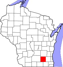 | |
| Villages | ||
| Towns | ||
| CDPs | ||
| Unincorporated communities |
| |
| Footnotes | ‡This populated place also has portions in an adjacent county or counties | |