Sullivan, Wisconsin
| Sullivan, Wisconsin | |
|---|---|
| Village | |
|
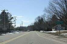
Looking west at downtown Sullivan | |
| Coordinates: 42°58′7″N 88°36′32″W / 42.96861°N 88.60889°WCoordinates: 42°58′7″N 88°36′32″W / 42.96861°N 88.60889°W | |
| Country | United States |
| State | Wisconsin |
| County | Jefferson |
| Government | |
| • Type | Village Board |
| • President | Terrisa Laurin |
| Area[1] | |
| • Total | 1.14 sq mi (2.95 km2) |
| • Land | 1.14 sq mi (2.95 km2) |
| • Water | 0 sq mi (0 km2) |
| Elevation[2] | 837 ft (255 m) |
| Population (2010)[3] | |
| • Total | 669 |
| • Estimate (2012[4]) | 671 |
| • Density | 586.8/sq mi (226.6/km2) |
| Time zone | Central (CST) (UTC-6) |
| • Summer (DST) | CDT (UTC-5) |
| Area code(s) | 262 |
| FIPS code | 55-78200[5] |
| GNIS feature ID | 1584246[2] |
| Website | http://www.villageofsullivan-gov.us/ |

Sullivan (formerly Winfield) is a village in Jefferson County, Wisconsin, United States. The population was 669 at the 2010 census.[6] The village is located within the Town of Sullivan, and is known to residents of southern Wisconsin including the Madison and Milwaukee metro areas as the location of the National Weather Service forecast office MKX.[7]
History
A post office called Sullivan has been in operation since 1846.[8] The village took its name from the Town of Sullivan.[9]
Geography
Sullivan is located at 43°0′46″N 88°35′15″W / 43.01278°N 88.58750°W (43.012791, -88.587515),[10] about 30 miles (48 km) west of Milwaukee and 40 miles (64 km) east of Madison, approximately 6 miles (10 km) south of Interstate 94. The center of the village is situated at the intersection of Main Street (Hwy 18 and Hwy F) and Palmyra Street (Hwy E).
According to the United States Census Bureau, the village has a total area of 1.14 square miles (2.95 km2), all land.[1]
Demographics
| Historical population | |||
|---|---|---|---|
| Census | Pop. | %± | |
| 1920 | 320 | — | |
| 1930 | 323 | 0.9% | |
| 1940 | 286 | −11.5% | |
| 1950 | 349 | 22.0% | |
| 1960 | 418 | 19.8% | |
| 1970 | 467 | 11.7% | |
| 1980 | 434 | −7.1% | |
| 1990 | 432 | −0.5% | |
| 2000 | 688 | 59.3% | |
| 2010 | 669 | −2.8% | |
| Est. 2015 | 671 | [11] | 0.3% |
2010 census

As of the census[3] of 2010, there were 669 people, 304 households, and 177 families residing in the village. The population density was 586.8 inhabitants per square mile (226.6/km2). There were 328 housing units at an average density of 287.7 per square mile (111.1/km2). The racial makeup of the village was 98.1% White, 0.3% African American, 0.1% Native American, 0.3% Asian, and 1.2% from two or more races. Hispanic or Latino of any race were 1.6% of the population.
There were 304 households of which 29.9% had children under the age of 18 living with them, 43.4% were married couples living together, 7.9% had a female householder with no husband present, 6.9% had a male householder with no wife present, and 41.8% were non-families. 36.2% of all households were made up of individuals and 12.8% had someone living alone who was 65 years of age or older. The average household size was 2.20 and the average family size was 2.86.
The median age in the village was 38.6 years. 22.7% of residents were under the age of 18; 6% were between the ages of 18 and 24; 29.3% were from 25 to 44; 30.2% were from 45 to 64; and 11.8% were 65 years of age or older. The gender makeup of the village was 48.6% male and 51.4% female.
2000 census
As of the census[5] of 2000, there were 688 people, 298 households, and 185 families residing in the village. The population density was 614.2 people per square mile (237.2/km²). There were 321 housing units at an average density of 286.6 per square mile (110.7/km²). The racial makeup of the village was 98.98% White, 0.15% Black or African American, 0.29% Native American, 0.29% Asian, 0.15% from other races, and 0.15% from two or more races. 0.15% of the population were Hispanic or Latino of any race.
There were 298 households out of which 30.2% had children under the age of 18 living with them, 49.3% were married couples living together, 6.7% had a female householder with no husband present, and 37.9% were non-families. 30.5% of all households were made up of individuals and 9.7% had someone living alone who was 65 years of age or older. The average household size was 2.31 and the average family size was 2.92.
In the village the population was spread out with 22.2% under the age of 18, 9.9% from 18 to 24, 39.2% from 25 to 44, 18.3% from 45 to 64, and 10.3% who were 65 years of age or older. The median age was 34 years. For every 100 females there were 104.8 males. For every 100 females age 18 and over, there were 109.0 males.
The median income for a household in the village was $43,229, and the median income for a family was $50,833. Males had a median income of $36,875 versus $27,404 for females. The per capita income for the village was $24,621. About 1.0% of families and 1.8% of the population were below the poverty line, including 2.2% of those under age 18 and 2.4% of those age 65 or over.
Education
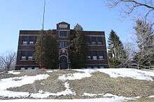
Sullivan Elementary School was the only school in the village but is no longer open
- However, a new Sullivan Elementary School was built nearby and is part of Jefferson School District. It is located only a few blocks from Main Street.
References
- 1 2 "US Gazetteer files 2010". United States Census Bureau. Retrieved 2012-11-18.
- 1 2 "US Board on Geographic Names". United States Geological Survey. 2007-10-25. Retrieved 2008-01-31.
- 1 2 "American FactFinder". United States Census Bureau. Retrieved 2012-11-18.
- ↑ "Population Estimates". United States Census Bureau. Retrieved 2013-06-24.
- 1 2 "American FactFinder". United States Census Bureau. Retrieved 2008-01-31.
- ↑ "Profile of General Population and Housing Characteristics: 2010 Demographic Profile Data (DP-1): Sullivan village, Wisconsin". U.S. Census Bureau, American Factfinder. Retrieved October 5, 2012.
- ↑ MKX
- ↑ "Jefferson County". Jim Forte Postal History. Retrieved 21 March 2015.
- ↑ Chicago and North Western Railway Company (1908). A History of the Origin of the Place Names Connected with the Chicago & North Western and Chicago, St. Paul, Minneapolis & Omaha Railways. p. 128.
- ↑ "US Gazetteer files: 2010, 2000, and 1990". United States Census Bureau. 2011-02-12. Retrieved 2011-04-23.
- ↑ "Annual Estimates of the Resident Population for Incorporated Places: April 1, 2010 to July 1, 2015". Retrieved July 2, 2016.
- ↑ "Census of Population and Housing". Census.gov. Retrieved June 4, 2015.
External links
| Wikimedia Commons has media related to Sullivan, Wisconsin. |
 |
| |||
| Johnson Creek, Wisconsin | |
|||
| ||||
| | ||||
Municipalities and communities of Jefferson County, Wisconsin, United States | ||
|---|---|---|
| Cities | 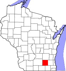 | |
| Villages | ||
| Towns | ||
| CDPs | ||
| Unincorporated communities |
| |
| Footnotes | ‡This populated place also has portions in an adjacent county or counties | |