Laughlintown, Pennsylvania
| Laughlintown, Pennsylvania | |
|---|---|
| Unincorporated community | |
|
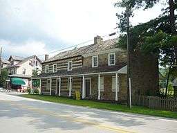
The Compass Inn in Laughlintown | |
 Laughlintown | |
| Coordinates: 40°12′43″N 79°11′52″W / 40.21194°N 79.19778°WCoordinates: 40°12′43″N 79°11′52″W / 40.21194°N 79.19778°W | |
| Country | United States |
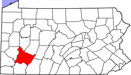
| State | Pennsylvania |
| County | Westmoreland |
| Elevation | 1,289 ft (393 m) |
| Time zone | Eastern (EST) (UTC-5) |
| • Summer (DST) | EDT (UTC-4) |
| ZIP code | 15655 |
| Area code(s) | 724 |
| GNIS feature ID | 1178918[1] |
Laughlintown is an unincorporated community in Ligonier Township, Westmoreland County, Pennsylvania, United States.[1] Laughlintown is located on U.S. Route 30 3 miles (4.8 km) southeast of Ligonier. Laughlintown has a post office with ZIP code 15655, which opened on May 16, 1825.[2][3]
The Compass Inn, which is listed on the National Register of Historic Places, is located in Laughlintown. Also the Rolling Rock Club is located in Laughlintown.[4]
Notes
- 1 2 "Laughlintown". Geographic Names Information System. United States Geological Survey.
- ↑ United States Postal Service (2012). "USPS - Look Up a ZIP Code". Retrieved 2012-02-15.
- ↑ "Postmaster Finder - Post Offices by ZIP Code". United States Postal Service. Retrieved May 22, 2013.
- ↑ National Park Service (2010-07-09). "National Register Information System". National Register of Historic Places. National Park Service.
This article is issued from Wikipedia - version of the 9/5/2016. The text is available under the Creative Commons Attribution/Share Alike but additional terms may apply for the media files.