Smithton, Pennsylvania
| Smithton, Pennsylvania | |
|---|---|
| Borough | |
|
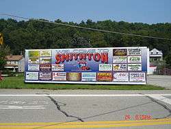
Smithton welcome sign | |
 Smithton | |
| Coordinates: 40°09′14″N 79°44′26″W / 40.15389°N 79.74056°WCoordinates: 40°09′14″N 79°44′26″W / 40.15389°N 79.74056°W | |
| Country | United States |
| State | Pennsylvania |
| County | Westmoreland |
| Incorporated | February 2, 1901 |
| Government | |
| • Type | Borough Council |
| • Mayor | Christine Tutena[1] |
| Area | |
| • Total | 0.1 sq mi (0.3 km2) |
| Elevation | 810 ft (250 m) |
| Population (2000) | |
| • Total | 444 |
| • Density | 3,858.5/sq mi (1,489.8/km2) |
| Time zone | Eastern (EST) (UTC-5) |
| • Summer (DST) | EDT (UTC-4) |
| Zip code | 15479 |
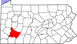
Smithton is a borough in Westmoreland County, Pennsylvania, United States. The population was 444 at the 2000 census.
Smithton's early industry was in coal mining, coke ovens, and shipping goods produced in the valley of Jacobs Creek.
Stoney's Beer was brewed by the Jones Brewing Company in Smithton until 2002 when the brewing operation was moved to Latrobe, Pennsylvania.[2]
Smithton is serviced by Yough School District
The Youghiogheny River runs along Smithton's western limits.
Geography
Smithton is located at 40°9′14″N 79°44′26″W / 40.15389°N 79.74056°W (40.153985, -79.740531).[3]
According to the United States Census Bureau, the borough has a total area of 0.1 square miles (0.26 km2), all of it land.
Demographics
| Historical population | |||
|---|---|---|---|
| Census | Pop. | %± | |
| 1910 | 784 | — | |
| 1920 | 790 | 0.8% | |
| 1930 | 709 | −10.3% | |
| 1940 | 737 | 3.9% | |
| 1950 | 690 | −6.4% | |
| 1960 | 649 | −5.9% | |
| 1970 | 552 | −14.9% | |
| 1980 | 559 | 1.3% | |
| 1990 | 388 | −30.6% | |
| 2000 | 444 | 14.4% | |
| 2010 | 399 | −10.1% | |
| Est. 2015 | 381 | [4] | −4.5% |
| Sources:[5][6][7] | |||
As of the census[6] of 2000, there were 444 people, 188 households, and 124 families residing in the borough. The population density was 3,858.5 people per square mile (1,428.6/km²). There were 208 housing units at an average density of 1,807.6 per square mile (669.2/km²). The racial makeup of the borough was 99.10% White, 0.23% Native American, and 0.68% from two or more races.
There were 188 households out of which 29.3% had children under the age of 18 living with them, 52.1% were married couples living together, 11.7% had a female householder with no husband present, and 34.0% were non-families. 30.9% of all households were made up of individuals and 17.0% had someone living alone who was 65 years of age or older. The average household size was 2.36 and the average family size was 2.94.
In the borough the population was spread out with 24.3% under the age of 18, 6.1% from 18 to 24, 26.4% from 25 to 44, 24.1% from 45 to 64, and 19.1% who were 65 years of age or older. The median age was 39 years. For every 100 females there were 90.6 males. For every 100 females age 18 and over, there were 86.7 males.
The median income for a household in the borough was $28,854, and the median income for a family was $36,250. Males had a median income of $26,667 versus $23,056 for females. The per capita income for the borough was $16,715. About 7.1% of families and 14.6% of the population were below the poverty line, including 22.0% of those under age 18 and 7.2% of those age 65 or over.

Government
Smithton has a small local government that consists of 7 Council members and a Mayor. Borough meetings are held on the 2nd Tuesday of each month.
The Smithton Borough Police Department has 8 sworn Police Officers, one full-time officer and 7 part-time officers.
Notable people
- Shirley Jones, actress
References
- ↑ "Best wishes to new office holders". Valley Independent. 2010-01-06. Retrieved 2010-01-21.
- ↑ "History of Stoney's Beer". Retrieved 9 August 2011.
- ↑ "US Gazetteer files: 2010, 2000, and 1990". United States Census Bureau. 2011-02-12. Retrieved 2011-04-23.
- ↑ "Annual Estimates of the Resident Population for Incorporated Places: April 1, 2010 to July 1, 2015". Retrieved July 2, 2016.
- ↑ "Census of Population and Housing". U.S. Census Bureau. Retrieved 11 December 2013.
- 1 2 "American FactFinder". United States Census Bureau. Retrieved 2008-01-31.
- ↑ "Incorporated Places and Minor Civil Divisions Datasets: Subcounty Resident Population Estimates: April 1, 2010 to July 1, 2012". Population Estimates. U.S. Census Bureau. Retrieved 11 December 2013.
| Counties |  Map of the Pittsburgh Tri-State with green counties in the metropolitan area and yellow counties in the combined area. | |
|---|---|---|
| Major cities | ||
| Cities and towns 15k-50k (in 2010) | ||
| Airports | ||
| Topics | ||
| ||