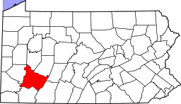
Youngwood, Pennsylvania
| Youngwood, Pennsylvania | |
|---|---|
| Borough | |
|
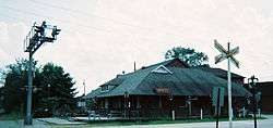
Youngwood business district (Depot Street) | |
 Youngwood, Pennsylvania | |
| Coordinates: 40°14′22″N 79°34′50″W / 40.23944°N 79.58056°WCoordinates: 40°14′22″N 79°34′50″W / 40.23944°N 79.58056°W | |
| Country | United States |
| State | Pennsylvania |
| County | Westmoreland |
| Settled | 1899 |
| Incorporated | November 10, 1902 |
| Government | |
| • Type | Borough Council |
| Area | |
| • Total | 1.9 sq mi (5 km2) |
| • Land | 1.8 sq mi (5 km2) |
| • Water | 0.1 sq mi (0.3 km2) |
| Elevation | 954 ft (291 m) |
| Population (2000) | |
| • Total | 4,138 |
| • Density | 2,249.2/sq mi (868.4/km2) |
| Time zone | Eastern (EST) (UTC-5) |
| • Summer (DST) | EDT (UTC-4) |
| Zip code | 15697 |
| Area code(s) | 724 |
| Website | http://www.youngwood.org |

Youngwood is a borough in Westmoreland County, Pennsylvania, United States.
History
The community was established in 1899 and was built on land owned by John Y. Woods, a farmer. In creating the name Youngwood, John Y. Woods took his own family name and combined it with his maternal grandfather's name, which was Young.[1]
Youngwood owes its existence to the Southwest Branch of the Pennsylvania Railroad, which ran from Greensburg south to Uniontown and Fairchance. In 1900, a large classification yard was built for sorting railroad cars, and this railroad yard provided Youngwood's economic base for many decades.
Youngwood became a borough on November 10, 1902.[2] The year 1902 was also the date of Youngwood's railroad station, which still stands on Depot Street.
Geography
Youngwood is located at 40°14′22″N 79°34′50″W / 40.23944°N 79.58056°W (40.239566, -79.580686).[3]
According to the United States Census Bureau, the borough has a total area of 1.9 square miles (4.8 km²), of which, 1.8 square miles (4.8 km²) of it is land and 0.04 square miles (0.1 km²) of it (1.08%) is water.
Demographics
| Historical population | |||
|---|---|---|---|
| Census | Pop. | %± | |
| 1910 | 1,881 | — | |
| 1920 | 2,275 | 20.9% | |
| 1930 | 2,783 | 22.3% | |
| 1940 | 2,546 | −8.5% | |
| 1950 | 2,720 | 6.8% | |
| 1960 | 2,813 | 3.4% | |
| 1970 | 3,057 | 8.7% | |
| 1980 | 3,749 | 22.6% | |
| 1990 | 3,372 | −10.1% | |
| 2000 | 4,138 | 22.7% | |
| 2010 | 3,050 | −26.3% | |
| Est. 2015 | 2,956 | [4] | −3.1% |
| Sources:[5][6][7] | |||
As of the census[6] of 2000, there were 4,138 people, 1,506 households, and 891 families residing in the borough. The population density was 2,249.2 people per square mile (868.3/km²). There were 1,601 housing units at an average density of 870.2 per square mile (336.0/km²). The racial makeup of the borough was 87.68% White, 11.65% African American, 0.24% Native American, 0.17% Asian, 0.02% from other races, and 0.24% from two or more races. Hispanic or Latino of any race were 2.37% of the population.
There were 1,506 households out of which 23.5% had children under the age of 18 living with them, 45.9% were married couples living together, 10.2% had a female householder with no husband present, and 40.8% were non-families. 36.3% of all households were made up of individuals and 14.9% had someone living alone who was 65 years of age or older. The average household size was 2.14 and the average family size was 2.79.
In the borough the population was spread out with 14.7% under the age of 18, 8.5% from 18 to 24, 38.4% from 25 to 44, 21.7% from 45 to 64, and 16.8% who were 65 years of age or older. The median age was 39 years. For every 100 females there were 136.9 males. For every 100 females age 18 and over, there were 143.4 males.
The median income for a household in the borough was $32,917, and the median income for a family was $43,942. Males had a median income of $32,596 versus $22,429 for females. The per capita income for the borough was $17,715. About 3.1% of families and 5.7% of the population were below the poverty line, including 2.7% of those under age 18 and 7.8% of those age 65 or over.
Westmoreland County Community College
The Main Campus of Westmoreland County Community College is located in Youngwood.
Notable people
- George Blanda, quarterback, kicker and member of the Pro Football Hall of Fame, was born in Youngwood.
References
- ↑ Boucher, John Newton (1918). Old and New Westmoreland, Volume 2. New York, New York: The American Historical Society. p. 640.
- ↑ "Westmoreland County (Dates of incorporation of municipalities)" (PDF). Pennsylvania Historical and Museum Commission. Retrieved 2008-11-13.
- ↑ "US Gazetteer files: 2010, 2000, and 1990". United States Census Bureau. 2011-02-12. Retrieved 2011-04-23.
- ↑ "Annual Estimates of the Resident Population for Incorporated Places: April 1, 2010 to July 1, 2015". Retrieved July 2, 2016.
- ↑ "Census of Population and Housing". U.S. Census Bureau. Archived from the original on May 11, 2015. Retrieved 11 December 2013.
- 1 2 "American FactFinder". United States Census Bureau. Retrieved 2008-01-31.
- ↑ "Incorporated Places and Minor Civil Divisions Datasets: Subcounty Resident Population Estimates: April 1, 2010 to July 1, 2012". Population Estimates. U.S. Census Bureau. Archived from the original on June 17, 2013. Retrieved 11 December 2013.
External links
| Counties |  Map of the Pittsburgh Tri-State with green counties in the metropolitan area and yellow counties in the combined area. | |
|---|---|---|
| Major cities | ||
| Cities and towns 15k-50k (in 2010) | ||
| Airports | ||
| Topics | ||
| ||