Lechmere (MBTA station)
LECHMERE | ||||||||||||||||||||||||||||||||||||
|---|---|---|---|---|---|---|---|---|---|---|---|---|---|---|---|---|---|---|---|---|---|---|---|---|---|---|---|---|---|---|---|---|---|---|---|---|
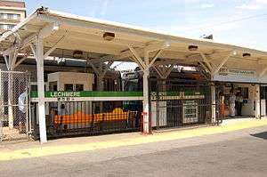 The inbound entrance to Lechmere, with faregates at right | ||||||||||||||||||||||||||||||||||||
| Location |
Cambridge Street at O'Brien Highway East Cambridge, Massachusetts | |||||||||||||||||||||||||||||||||||
| Coordinates | 42°22′15.3″N 71°04′39″W / 42.370917°N 71.07750°WCoordinates: 42°22′15.3″N 71°04′39″W / 42.370917°N 71.07750°W | |||||||||||||||||||||||||||||||||||
| Owned by | MBTA | |||||||||||||||||||||||||||||||||||
| Line(s) | ||||||||||||||||||||||||||||||||||||
| Platforms | 2 side platforms | |||||||||||||||||||||||||||||||||||
| Tracks | 1 (balloon loop) | |||||||||||||||||||||||||||||||||||
| Construction | ||||||||||||||||||||||||||||||||||||
| Parking | 347 spaces ($6.00 fee) | |||||||||||||||||||||||||||||||||||
| Disabled access | Yes | |||||||||||||||||||||||||||||||||||
| History | ||||||||||||||||||||||||||||||||||||
| Opened | July 10, 1922 | |||||||||||||||||||||||||||||||||||
| Rebuilt | 2010; December 2017 (planned) | |||||||||||||||||||||||||||||||||||
| Traffic | ||||||||||||||||||||||||||||||||||||
| Passengers (2013) | 6,421 (weekday average boardings)[1] | |||||||||||||||||||||||||||||||||||
| Services | ||||||||||||||||||||||||||||||||||||
| ||||||||||||||||||||||||||||||||||||
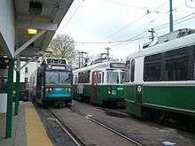
Lechmere is a light rail station and the present-day northern terminus of the MBTA Green Line. It is located at Lechmere Square in East Cambridge, Massachusetts near the intersection of Cambridge Street and Monsignor O'Brien Highway (Route 28). Green Line trains run around a balloon loop, inside which is a small yard used for midday and overnight storage. The station has two platforms, which are not connected within fare control; the outbound terminus is on the northeast side of the loop and the inbound platform is on the southwest side. Lechmere station is fully handicapped accessible.
As part of the Green Line Extension project, the current (1922-built) Lechmere station is planned to be demolished. A new elevated station will be built on the opposite side of the O'Brien Highway. This station will be adjacent to the Northpoint development and will have a direct connection to the Somerville Community Path. The new station is planned to open in 2017, and will be an intermediate station on the "D" and "E" branches and will no longer serve as a terminus.[2][3]
History

When the Tremont Street Subway fully opened in 1898, surface cars entering the subway from Cambridge Street and Bridge Street in East Cambridge had to cross Craigie's Bridge and proceed on surface streets to the Canal Street Incline. The trip from Lechmere Point over the bridge was slow and prone to delays. After five years of construction, the Lechmere Viaduct and Causeway Street Elevated opened on June 1, 1912, providing the streetcar routes from Harvard Square and much of Somerville a direct route into the subway.[4]
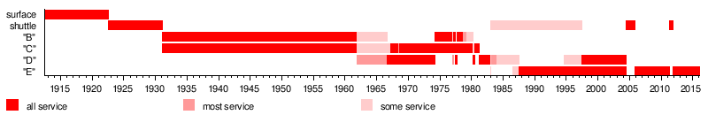
The surface lines that fed into the subway via Lechmere Square had poor schedule reliability, which became a larger issue as the Tremont Street Subway and connecting lines became a rapid transit service in its own right rather than merely a collection of existing streetcar lines. On July 10, 1922, the Boston Elevated Railway opened a prepayment station at Lechmere.[4] Typical of BERy projects, it was set up for efficient transfers between rapid transit and surface collector lines. A balloon loop with separate inbound and outbound platforms served terminating trains from the subway, with off-street streetcar boarding areas next to each. Surface cars could drop off passengers at the inbound platform off Cambridge Street, proceed under the elevated line, then board passengers at the outbound platform off Bridge Street. Connections between the surface and elevated tracks allowed cars to move between them if needed, and a small storage yard was located inside the balloon loop
As most existing subway service from the south and west looped at Park Street, a new service was inaugurated between Lechmere and the Pleasant Street Incline. Beginning January 2, 1923, this was changed to loop at Kenmore (a surface station at the time) and some trips were extended along the Beacon Street Line to loop at Washington Square. On February 7, 1931, Commonwealth Avenue and Beacon Street service was extended from Park Street to Lechmere, and the separate shuttle service to Lechmere was discontinued.
The 66 streetcar (later renumbered as the 77, then the 69) was the first route to be converted to trackless trolley in 1936. The remaining surface routes out of Lechmere were converted to trackless and later bus over the next three decades. The inbound side surface boarding area was eventually disused; the outbound side was converted to a busway and the direction of traffic through it reversed for improved bus operations.
MBTA era
Several years after it was inaugurated in 1959, the Riverside Line was extended to Lechmere at most times. The MBTA took over transit operations in 1964. With the ability to reverse Green Line trains at Park Street, Government Center, North Station, and Lechmere, the MBTA frequently switched which lines ran to which downtown terminals to match passenger demands and other operational needs. On September 10, 1966, the remaining Commonwealth Avenue line service to Lechmere was cut back to Park Street.[4] In 1967, the MBTA redesignated the remaining streetcar operations as the Green Line with branches "A" through "E". The Commonwealth Avenue line became the "B" Branch, the Beacon Street line the "C" Branch, and the Riverside line the "D" Branch. After March 25, 1967, the "C" and "D" branches served Lechmere at all times.[4]
On March 25, 1974, the "B" Branch was extended back to Lechmere and the "D" cut to North Station; for the next decade, the "B", "C", and "D" frequently were switched between Lechmere and other termini. On January 2, 1983, for the first time in the station's history trains from Huntington Avenue (the "E" Branch) began serving Lechmere.[4] On February 11, 1983, the "E" Branch was shut down by snow for several days; a Government Center - Lechmere shuttle ran in its stead, soon joined by some "D" Branch service.[4] From December 28, 1985 to July 25, 1986, additional shuttle service ran between Lechmere and Kenmore. "E" Branch service resumed to Lechmere partially on July 26, and fully on June 20, 1987. The remaining Lechmere - Government Center shuttles were replaced with an extension of "D" Branch service on June 21, 1997.[4]
On June 25, 2004, service to Lechmere was suspended as the Causeway Street Elevated was removed, and the surface and elevated platforms at North Station were consolidated into a new underground "superstation". A shuttle bus to Government Center accommodated Lechmere passengers. Service to Lechmere, operated only by the "E" Branch, resumed on November 12, 2005.[4] Service past North Station was replaced with buses from April 30 to November 4, 2011, as Science Park station was rebuilt with handicapped-accessible platforms and new elevators.[4][5][6]
Green Line Extension and new station
The MBTA has proposed that it will break ground for the construction of a new Lechmere station, located on the opposite side of McGrath/O'Brien Highway in a new community called NorthPoint, as part of the Green Line Extension. Planned to open by 2017,[7] the relocated station will connect with the associated Somerville Community Path.[8] However, As of December 2015, the future of the project is in doubt due to a substantial increase in costs; it will likely be further delayed or cancelled.[9]
The moved Lechmere station is a proposed stop on the MBTA's planned Urban Ring Project.[10] The Urban Ring will be a Bus Rapid Transit (BRT) Line designed to connect the current radial MBTA Lines to reduce strain on the downtown stations.
Bus connections

The outbound terminus platform is connected to a busway on the Monsignor O'Brien Highway, which serves several MBTA Bus routes:
- 69 Harvard/Holyoke Gate - Lechmere Station via Cambridge Street
- 80 Arlington Center - Lechmere Station via Medford Hillside
- 87 Arlington Center or Clarendon Hill - Lechmere Station via Somerville Avenue
- 88 Clarendon Hill - Lechmere Station via Highland Avenue
A busway is present on the inbound side as well; however, it is not currently used by buses.
The EZRide Cambridge - North Station private shuttle service stops at Lechmere at all times. Although not part of the MBTA system, it is open to the general public and is shown on MBTA maps.
References
- ↑ "Ridership and Service Statistics" (PDF) (14 ed.). Massachusetts Bay Transportation Authority. 2014. Archived from the original (PDF) on 12 September 2014. Retrieved 30 July 2014.
- ↑ "MBTA Light Rail Transit System OPERATIONS AND MAINTENANCE PLAN" (PDF). Massachusetts Bay Transportation Authority. 6 January 2011. Retrieved 10 August 2015.
- ↑ "Travel Forecasts: Systemwide Stats and SUMMIT Results" (PDF). Green Line Extension Project: FY 2012 New Starts Submittal. Massachusetts Department of Transportation. January 2012. Retrieved 10 August 2015.
- 1 2 3 4 5 6 7 8 9 Belcher, Jonathan (27 June 2015). "Changes to Transit Service in the MBTA district 1964-2015" (PDF). NETransit. Retrieved 11 August 2015.
- ↑ "Science Park/West End Improvement Project". Massachusetts Bay Transportation Authority. Archived from the original on 5 January 2012.
- ↑ "Trolley service to resume as project ends". Boston Globe. 3 November 2011. Retrieved 11 August 2015.
- ↑ Parker, Brock (2011-12-15). "New Lechmere T station could open in early 2017". The Boston Globe. pp. n/a. Retrieved 2011-12-21.
- ↑ Palmer, Jr., Thomas C. (2006-10-23). "The train comes to NorthPoint". The Boston Globe. pp. n/a. Retrieved 2006-12-18.
- ↑ Vaccaro, Adam (14 December 2015). "Transit officials won't commit additional state money to Green Line extension". Boston Globe. Retrieved 15 December 2015.
- ↑ https://www.commentmgr.com/projects/1169/docs/URnews0105c.pdf
External links
| Wikimedia Commons has media related to Lechmere (MBTA station). |
| Subway lines (List of stations) |
| |||||||||||
|---|---|---|---|---|---|---|---|---|---|---|---|---|
| Commuter Rail lines (List of stations) |
| |||||||||||
| Bus routes (List of routes) | ||||||||||||
| Other services | ||||||||||||
| Component parts of system lines | ||||||||||||
| Capital projects |
| |||||||||||
| History |
| |||||||||||
| Other | ||||||||||||