Lee, Massachusetts
| Lee, Massachusetts | ||
|---|---|---|
| Town | ||
|
Town Hall | ||
| ||
| Nickname(s): Wildcats | ||
| Motto: "Gateway to the Berkshires" | ||
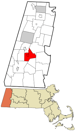 Location in Berkshire County and the state of Massachusetts. | ||
| Coordinates: 42°18′15″N 73°14′55″W / 42.30417°N 73.24861°WCoordinates: 42°18′15″N 73°14′55″W / 42.30417°N 73.24861°W | ||
| Country | United States | |
| State | Massachusetts | |
| County | Berkshire | |
| Settled | 1760 | |
| Incorporated | 1777 | |
| Government | ||
| • Type | Representative town meeting | |
| Area | ||
| • Total | 27.0 sq mi (70.0 km2) | |
| • Land | 26.1 sq mi (67.7 km2) | |
| • Water | 0.9 sq mi (2.3 km2) | |
| Elevation | 1,000 ft (305 m) | |
| Population (2010) | ||
| • Total | 5,943 | |
| • Density | 227/sq mi (87.8/km2) | |
| Time zone | Eastern (UTC-5) | |
| • Summer (DST) | Eastern (UTC-4) | |
| ZIP code | 01238 | |
| Area code(s) | 413 | |
| FIPS code | 25-34655 | |
| GNIS feature ID | 0618268 | |
| Website |
www | |


Lee is a town in Berkshire County, Massachusetts, United States settled by. It is part of the Pittsfield, Massachusetts, metropolitan statistical area. The population was 5,943 at the 2010 census.[1] Lee, which includes the villages of South and East Lee, is part of the Berkshires resort area.
History
Lee occupies land which was originally territory of Mahican Indians. The first non-native settlement in the area was known as Dodgetown as early as 1760. Dodgetown was named after its founding settler, Asahel Dodge, who immigrated to the area from Cape Cod. Lee was incorporated in 1777 from parts of Great Barrington and Washington. It is named after Revolutionary War General Charles Lee.[2] Lee is a former mill town.
In the autumn of 1786 during Shays' Rebellion, about 250 followers of Daniel Shays encountered state troops commanded by General John Paterson near East Lee. The Shaysites paraded a fake cannon crafted from a yarn beam, and the troops fled.
Early industries included agriculture, lumbering, and lime making. Abundant streams and rivers provided water power for mills which produced textiles and wire. In 1806, papermaking became the principal industry with the construction of the Willow Mill by Samuel Church in South Lee. In 1827, the Columbia Mill in central Lee was established, and would eventually be the first to supply 100% groundwood newsprint to The New York Times. By 1857, there were 25 paper mills in Lee. The Smith Paper Company discovered how to manufacture paper solely from wood pulp in 1867, and through the 1870s was the largest producer of paper in the country. The mills previously owned by Smith Paper Company were closed in 2008.[3] Today, Lee has only a single papermaking facility.
The town's marble is famous for its quality. The first quarry was established in 1852. In 1867, almost 500,000 cubic feet (14,000 m3) of marble was excavated and shipped on the Housatonic Railroad. Buildings constructed of Lee marble include a wing of the Capitol in Washington and St. Patrick's Cathedral in New York City.
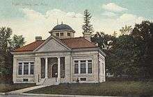
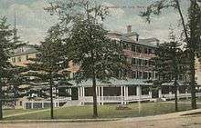
The town's 19th century prosperity is still evident in its architecture, including its town hall, library, several churches and private homes. South Lee includes a historic district listed on the National Register.
Lee has become a popular tourist destination, noted both for its New England charm and its bed and breakfast establishments. It is known as the "Gateway to The Berkshires" because it provides one of only two exits on the Massachusetts Turnpike which serve the county, and the only one going eastbound.
Arlo Guthrie's court appearance before the blind judge and his seeing-eye dog for dumping garbage as noted in the song "Alice's Restaurant" took place in the courtroom at the Lee town Hall pictured above.
Lee was a filming location for Before and After (1996) and The Cider House Rules (1999).
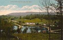
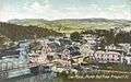 North End c. 1907
 Columbia Mills c. 1912
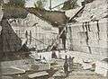 Marble quarry c. 1905
Geography
According to the United States Census Bureau, the town has a total area of 27.0 square miles (70.0 km2), of which 26.1 sq mi (67.7 km2) is land and 0.89 sq mi (2.3 km2), or 3.22%, is water.[1] Lee is bordered by Lenox to the northwest, Washington to the northeast, Becket to the east, Tyringham in the southeast, Great Barrington to the southwest, and Stockbridge to the west. Lee is 10 miles (16 km) south of Pittsfield, 42 miles (68 km) west-northwest of Springfield, and 125 miles (201 km) west of Boston.
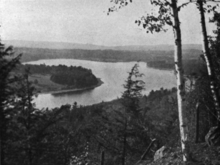
Lee is located in the southern section of the Berkshires, in a valley along the Housatonic River. The town lies to the west of October Mountain State Forest, with two sections of the forest in Lee. In the southwest corner of town lies a portion of Beartown State Forest, where Burgoyne Pass crosses the northern end of the mountain. Hop Brook, a marshy brook which flows from Tyringham, flows into the Housatonic in the south, and other bodies of water include Laurel Lake to the north, and Goose Pond to the southeast. The Appalachian Trail skirts the eastern part of the town, passing through Tyringham, Becket and Washington.
Lee is located along Interstate 90 (the Massachusetts Turnpike), and is home to Exit 2, the westernmost full exit on the turnpike (Exit 1, in West Stockbridge, is only a turnaround exit) as well as the first service area along the Pike. Lee lies along U.S. Route 20, the "old Mass Pike", which was the main route to New York state prior to the interstate. A small section of U.S. Route 7 crosses through the northwest corner of town before meeting Route 20 in Lenox. Massachusetts Route 102's eastern terminus is located at Route 20 at the Exit 2 toll plaza.
Lee lies along the Housatonic Railroad line, which travels from Pittsfield, through Lee to Great Barrington and Sheffield, terminating near at New Milford, Connecticut, near Danbury. The line is still the area's primary rail link to New York City's metropolitan area, to Boston, and to Albany. Currently (2013) there are negotiations of restoring rail commuter service between the Berkshires and New York City along this route. The town is covered by the Berkshire Regional Transit Authority (BRTA) bus line, which travels between Pittsfield and Great Barrington. Regional bus services make regularly daily stops, and maintain year round schedules through Lee. Peter Pan and Bonanza Bus Lines each make scheduled stops at town hall, downtown.
Regional air service can be reached at Pittsfield Municipal Airport. The nearest national and international air services can be reached at Albany International Airport in Albany, New York, about 55 miles (89 km) away. Bradley International Airport, located near Hartford, Connecticut, is also a popular option for travelers, situated approximately 70 miles (110 km) from Lee.
| Climate data for Lee, Massachusetts (01238) | |||||||||||||
|---|---|---|---|---|---|---|---|---|---|---|---|---|---|
| Month | Jan | Feb | Mar | Apr | May | Jun | Jul | Aug | Sep | Oct | Nov | Dec | Year |
| Average high °F (°C) | 29 (−2) |
32 (0) |
41 (5) |
54 (12) |
65 (18) |
73 (23) |
78 (26) |
76 (24) |
68 (20) |
56 (13) |
45 (7) |
34 (1) |
54.3 (12.3) |
| Average low °F (°C) | 13 (−11) |
15 (−9) |
22 (−6) |
34 (1) |
45 (7) |
54 (12) |
59 (15) |
57 (14) |
50 (10) |
38 (3) |
30 (−1) |
20 (−7) |
36.4 (2.3) |
| Average precipitation inches (mm) | 3.91 (99.3) |
3.74 (95) |
4.31 (109.5) |
4.36 (110.7) |
4.50 (114.3) |
4.90 (124.5) |
4.75 (120.7) |
4.53 (115.1) |
4.36 (110.7) |
5.03 (127.8) |
4.50 (114.3) |
4.36 (110.7) |
53.25 (1,352.6) |
| Source: The Weather Channel[4] | |||||||||||||
Demographics
See also: Lee (CDP), Massachusetts
| Historical population | ||
|---|---|---|
| Year | Pop. | ±% |
| 1850 | 3,220 | — |
| 1860 | 4,420 | +37.3% |
| 1870 | 3,866 | −12.5% |
| 1880 | 3,939 | +1.9% |
| 1890 | 3,785 | −3.9% |
| 1900 | 3,596 | −5.0% |
| 1910 | 4,106 | +14.2% |
| 1920 | 4,085 | −0.5% |
| 1930 | 4,061 | −0.6% |
| 1940 | 4,222 | +4.0% |
| 1950 | 4,820 | +14.2% |
| 1960 | 5,271 | +9.4% |
| 1970 | 6,426 | +21.9% |
| 1980 | 6,247 | −2.8% |
| 1990 | 5,849 | −6.4% |
| 2000 | 5,985 | +2.3% |
| 2010 | 5,943 | −0.7% |
| * = population estimate. Source: United States Census records and Population Estimates Program data.[5][6][7][8][9][10][11][12][13][14] | ||
As of the census[15] of 2000, there were 5,985 people, 2,442 households, and 1,606 families residing in the town. By population, Lee ranks seventh out of the 32 cities and towns in Berkshire County, and 227th out of 351 cities and towns in Massachusetts. The population density was 226.7 people per square mile (87.5/km²), which ranks sixth in the county and 241st in the Commonwealth. There were 2,927 housing units at an average density of 110.9 per square mile (42.8/km²). The racial makeup of the town was 96.93% White, 0.62% Black or African American, 0.15% Native American, 0.95% Asian, 0.02% Pacific Islander, 0.74% from other races, and 0.60% from two or more races. Hispanic or Latino of any race were 2.49% of the population.
There were 2,492 households out of which 28.6% had children under the age of 18 living with them, 51.7% were married couples living together, 10.2% had a female householder with no husband present, and 34.2% were non-families. 28.2% of all households were made up of individuals and 12.6% had someone living alone who was 65 years of age or older. The average household size was 2.39 and the average family size was 2.91.
In the town the population was spread out with 22.1% under the age of 18, 7.0% from 18 to 24, 28.5% from 25 to 44, 25.6% from 45 to 64, and 16.8% who were 65 years of age or older. The median age was 40 years. For every 100 females there were 94.0 males. For every 100 females age 18 and over, there were 92.1 males.
The median income for a household in the town was $41,556, and the median income for a family was $49,630. Males had a median income of $35,565 versus $26,232 for females. The per capita income for the town was $19,799. About 2.5% of families and 6.7% of the population were below the poverty line, including 3.4% of those under age 18 and 4.2% of those age 65 or over.
Government
Lee uses the representative town meeting form of government, and is led by a board of selectmen and a town administrator. Lee has its own police, fire and public works departments, as well as a post office. The town's library is a member of the regional library networks.
On the state level, Lee is represented in the Massachusetts House of Representatives by the Fourth Berkshire district, which covers southern Berkshire County, as well as the westernmost towns in Hampden County. In the Massachusetts Senate, the town is represented by the Berkshire, Hampshire and Franklin district, which includes all of Berkshire County and western Hampshire and Franklin counties.[16] The town is home to the First Station of Barracks "B" of the Massachusetts State Police.[17]
On the national level, Lee is represented in the United States House of Representatives as part of Massachusetts's 1st congressional district, and is represented by Richard Neal of Springfield, Massachusetts. Massachusetts is currently represented in the United States Senate by senior Senator Elizabeth Warren and junior Senator Ed Markey.
Education
Lee operates its own school department, which also serves the town of Tyringham, and has an option to serve Becket, Otis, Sandisfield, and other surrounding towns. Lee Elementary School serves students from pre-kindergarten through sixth grades, and the Lee Middle and High School serves students from seventh through twelfth grades. Lee's athletics teams are nicknamed the Wildcats, and their colors are black and orange. Additionally, Lee is home to Saint Mary's School, a parochial school which serves students through eighth grade. Other private schools can be found in Great Barrington and other surrounding towns.
The nearest community college is the South County Center of Berkshire Community College in Great Barrington, and the nearest state university is Massachusetts College of Liberal Arts. The nearest private college is Bard College at Simon's Rock.
Sites of interest
- Museum of Animation, Special Effects & Art
- Festival Latino of the Berkshires
- October Mountain State Forest
Notable residents
- Arnie Armstrong, financier and developer - Old Lenox Tunnel
- Danny Bea, Composer & Instrumentalist - Gottwehrmz & Lohvem Orchestra
- Nathan. Bradley, congressman
- Henry Billings Brown, Associate Justice of the U.S. Supreme Court
- Michelle Cuevas, author
- Thomas C. Durant, financier and railroad promoter
- Frank Dwyer, baseball pitcher
- Elisha Foote, judge, inventor and mathematician
- Henri Gosselin, politician
- Christopher Hodgkins, politician
- Addison H. Laflin, congressman
- Wayne Larrivee, sportscaster
- Mark 'Ducky' Bellman, Impersonator / Entertainer
- Debra Jo Rupp, actress
- Augusta Read Thomas, composer
- Edward V. Whiton, Chief Justice of the Wisconsin Supreme Court
Notes
- 1 2 "Geographic Identifiers: 2010 Demographic Profile Data (G001): Lee town, Berkshire County, Massachusetts". U.S. Census Bureau, American Factfinder. Retrieved December 20, 2013.
- ↑ Gannett, Henry (1905). The Origin of Certain Place Names in the United States. U.S. Government Printing Office. p. 184.
- ↑ Lee Paper Mills -- Schweitzer-Mauduit International, Inc. Archived October 16, 2006, at the Wayback Machine.
- ↑ "Monthly Averages for Lee, MA (01238)" (Table). The Weather Channel Interactive.
- ↑ "TOTAL POPULATION (P1), 2010 Census Summary File 1". American FactFinder, All County Subdivisions within Massachusetts. United States Census Bureau. 2010.
- ↑ "Massachusetts by Place and County Subdivision - GCT-T1. Population Estimates". United States Census Bureau. Retrieved July 12, 2011.
- ↑ "1990 Census of Population, General Population Characteristics: Massachusetts" (PDF). US Census Bureau. December 1990. Table 76: General Characteristics of Persons, Households, and Families: 1990. 1990 CP-1-23. Retrieved July 12, 2011.
- ↑ "1980 Census of the Population, Number of Inhabitants: Massachusetts" (PDF). US Census Bureau. December 1981. Table 4. Populations of County Subdivisions: 1960 to 1980. PC80-1-A23. Retrieved July 12, 2011.
- ↑ "1950 Census of Population" (PDF). Bureau of the Census. 1952. Section 6, Pages 21-10 and 21-11, Massachusetts Table 6. Population of Counties by Minor Civil Divisions: 1930 to 1950. Retrieved July 12, 2011.
- ↑ "1920 Census of Population" (PDF). Bureau of the Census. Number of Inhabitants, by Counties and Minor Civil Divisions. Pages 21-5 through 21-7. Massachusetts Table 2. Population of Counties by Minor Civil Divisions: 1920, 1910, and 1920. Retrieved July 12, 2011.
- ↑ "1890 Census of the Population" (PDF). Department of the Interior, Census Office. Pages 179 through 182. Massachusetts Table 5. Population of States and Territories by Minor Civil Divisions: 1880 and 1890. Retrieved July 12, 2011.
- ↑ "1870 Census of the Population" (PDF). Department of the Interior, Census Office. 1872. Pages 217 through 220. Table IX. Population of Minor Civil Divisions, &c. Massachusetts. Retrieved July 12, 2011.
- ↑ "1860 Census" (PDF). Department of the Interior, Census Office. 1864. Pages 220 through 226. State of Massachusetts Table No. 3. Populations of Cities, Towns, &c. Retrieved July 12, 2011.
- ↑ "1850 Census" (PDF). Department of the Interior, Census Office. 1854. Pages 338 through 393. Populations of Cities, Towns, &c. Retrieved July 12, 2011.
- ↑ "American FactFinder". United States Census Bureau. Retrieved 2008-01-31.
- ↑ Senators and Representatives by City and Town
- ↑ Station B-1, SP Lee
References
-
 Chisholm, Hugh, ed. (1911). "Lee (Massachusetts)". Encyclopædia Britannica (11th ed.). Cambridge University Press.
External links
| Wikimedia Commons has media related to Lee, Massachusetts. |
Municipalities and communities of Berkshire County, Massachusetts, United States | ||
|---|---|---|
| Cities | 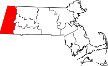 | |
| Towns | ||
| CDPs | ||
| Other villages | ||