Cape Cod
| Cape Cod | |
|---|---|
|
| |
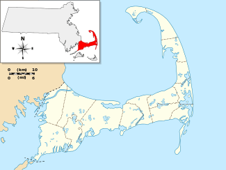 Cape Cod (Barnstable County), in Massachusetts | |
| Location | Massachusetts, United States |
| Coordinates | 41°41′N 70°12′W / 41.68°N 70.2°WCoordinates: 41°41′N 70°12′W / 41.68°N 70.2°W |
| Offshore water bodies | |
| Elevation | 306 ft (93 m) |
| Area | 339 sq mi (880 km2)[1] |
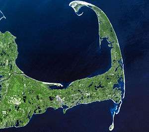
Cape Cod is a geographic cape extending into the Atlantic Ocean from the southeastern corner of mainland Massachusetts, in the northeastern United States. Its historic, maritime character and ample beaches attract heavy tourism during the summer months.
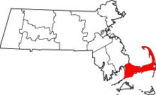
As defined by the Cape Cod Commission's enabling legislation, Cape Cod is conterminous with Barnstable County, Massachusetts.[2] It extends from Provincetown in the northeast to Woods Hole in the southwest, and is bordered by Plymouth to the northwest.
Since 1914, Cape Cod has been separated from the mainland by the Cape Cod Canal. The canal cuts 17.5 miles (28.2 km) roughly across the base of the peninsula, though small portions of the Cape Cod towns of Bourne and Sandwich lie on the mainland side of the canal. Two highway bridges cross the Cape Cod Canal: the Sagamore Bridge and the Bourne Bridge. In addition, the Cape Cod Canal Railroad Bridge carries railway freight and limited passenger services onto the Cape. Cape territory is divided into fifteen towns with many villages.
Region of Cape Cod and the Islands
Like Cape Cod itself, the islands south of the Cape have evolved from whaling and trading areas to become resort destinations, attracting wealthy families, celebrities, and other tourists. These include the large nearby islands of Nantucket and Martha's Vineyard which have grown in population by 6.8 percent and 10.3 percent, respectively, between 2000 and 2010 while the year-round population of Barnstable County dropped 3 percent according to the Census.[3] Both islands are also famous summer tourist destinations, commonly accessed by ferry from several locations on the cape. The phrases Cape Cod and the Islands and the Cape and Islands are often used to describe the whole region of Barnstable County, Dukes County (including Martha's Vineyard and the smaller Elizabeth Islands), and Nantucket County.
Several small islands right off Cape Cod, including Monomoy Island, Monomoscoy Island, Popponesset Island, and Seconsett Island, are also in Barnstable County.
The Forbes family-owned Naushon Island was first purchased by John Murray Forbes. Naushon is one of the Elizabeth Islands, many of which are privately owned. One of the publicly accessible Elizabeths is the southernmost island in the chain, Cuttyhunk, with a year-round population of 52 people. Several prominent families have established compounds or estates on the larger islands, making these islands some of the wealthiest resorts in the Northeast, yet they retain much of the early merchant trading and whaling culture.
Cape Cod in particular is a popular retirement area; 27.8% of the population of Barnstable County is 65 years old or older.,[4] and the average age of residents is the highest of any area in New England. By voter registration numbers, Democrats outnumber Republicans by less in the three counties than in the whole of Massachusetts, to varying degrees.[5]
The bulk of the land in the area is glacial terminal moraine and represents the southernmost extent of glacial coverage in southeast New England; similar glacial formations make up Long Island in New York and Block Island in Rhode Island.
Geography and political divisions
Physical geography and boundaries
The name "Cape Cod", as it was first used in 1602, applied only to the very tip of the peninsula. It remained that way for 125 years, until the "Precinct of Cape Cod" was incorporated as the Town of Provincetown. No longer in "official" use over the ensuing decades, the name came to mean all of the land east of the Manomet and Scusset rivers – essentially along the line that became the Cape Cod Canal. The creation of the canal separated the majority of the peninsula from the mainland, effectively turning it into an island.[1][6] Indeed, most agencies, including the Cape Cod Commission and the Federal Emergency Management Agency (FEMA), treat the Cape as an island with regard to disaster preparedness, groundwater management, and the like.[7] Most "Cape Codders" – residents of "The Cape" – refer to all land on the mainland side of the canal as "off-Cape." However, the legal delineation of Cape Cod, coincident to the boundaries of Barnstable County, extends to the northwest boundaries of the towns of Bourne and Sandwich – and small portions of each are located west of the canal.
Cape Cod Bay lies in between Cape Cod and the mainland – bounded on the north by a horizontal line between Provincetown and Marshfield. North of Cape Cod Bay (and Provincetown) is Massachusetts Bay, which contains the Stellwagen Bank National Marine Sanctuary, located 5 miles (8 km) north of Provincetown. The Atlantic Ocean is to the east of Cape Cod, and to the southwest of the Cape is Buzzards Bay. The Cape Cod Canal, completed in 1916, connects Buzzards Bay to Cape Cod Bay; its creation shortened the trade route between New York and Boston by 62 miles (100 km).[8]
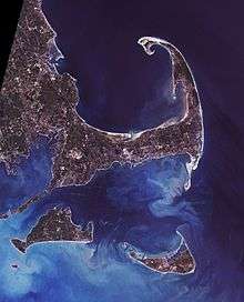
Cape Cod extends 65 miles (105 km) into the Atlantic Ocean, with a breadth of between 1–20 miles (1.6–32.2 km), and covers more than 400 miles (640 km) of shoreline.[9] Its elevation ranges from 306 feet (93 m) at its highest point, at the top of Pine Hill, in the Bourne portion of Joint Base Cape Cod, down to sea level.
One of the biggest barrier islands in the world, Cape Cod shields much of the Massachusetts coastline from North Atlantic storm waves. This protection erodes the Cape's shoreline at the expense of its cliffs, while protecting towns from Fairhaven to Marshfield.
Cape Cod and the Islands are part of a continuous archipelagic region consisting of a thin line of islands stretching west to include Long Island, in New York. This region is historically and collectively known by naturalists as the Outer Lands.
Towns and villages
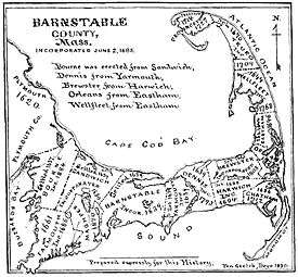
Cape Cod incorporates all of Barnstable County, which comprises 15 towns: Bourne, Sandwich, Falmouth, Mashpee, Barnstable, Yarmouth, Harwich, Dennis, Brewster, Chatham, Orleans, Eastham, Wellfleet, Truro, and Provincetown. Each of these towns include a number of villages; see Barnstable County for a complete list.
Barnstable, the most populated municipality on Cape Cod, is the only one to have adopted a city form of government, whose legislative body is an elected 13-member council.[10][11] However, Like other smaller Massachusetts cities, Barnstable retained its "Town of Barnstable" moniker. All of the other towns elect a 5-member Board of Selectmen as the executive policy-setting board, and utilize Town Meetings as their legislative body.[10]
Cape Cod and the Islands
To the south of Cape Cod lie Nantucket Sound; Nantucket and Martha's Vineyard, both large islands; and the mostly privately owned Elizabeth Islands.
Sections
Upper Cape
| |||||||||||||
Mid-Cape
| |||||||||||||
Lower Cape
| |||||||||||||
Outer Cape (occasionally, Lower Cape)
| |||||||||||||
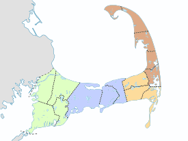

For most of the 18th, 19th, and 20th centuries, Cape Cod was considered to consist of three sections (see map):
- The Upper Cape is the part of Cape Cod closest to the mainland, comprising the towns of Bourne, Sandwich, Falmouth, and Mashpee. Falmouth is the home of the famous Woods Hole Oceanographic Institution and Marine Biological Laboratory as well as several other research organizations, and is also the most-used ferry connection to Martha's Vineyard. Falmouth is composed of several separate villages, including East Falmouth, Falmouth Village, Hatchville, North Falmouth, Teaticket, Waquoit, West Falmouth, and Woods Hole, as well as several smaller hamlets that are incorporated into their larger neighbors (e.g., Davisville, Hatchville, Falmouth Heights, Quissett, Sippewissett, and others).[12] Bourne is home to the Massachusetts Maritime Academy, in the village of Buzzards Bay, along the canal, Joint Base Cape Cod, Aptucxet Trading Post,[13] the annual Bourne Scallop Festival in September, and, until 1884, was part of Sandwich. Sandwich, the oldest town on Cape Cod, founded in 1637, is home to the Dexter Grist Mill, the historic Hoxie House, Heritage Museums and Gardens, the Sandwich Glass Museum, the Thornton Burgess Museum, the Green Briar Nature Center, a Friends' Meeting House, a U.S. Coast Guard Station, and many quaint inns and motels, restaurants, shops and activities. Mashpee, home of the Mashpee Wampanoag tribe of Native Americans, hosts Mashpee Commons, an outdoor shopping mall, with many boutiques, eateries, movie theaters, and offices, as is the newer South Cape Village, a short way south towards Falmouth, along Route 28; it is also home to New Seabury, an upscale residential golf community along Vineyard Sound, South Cape Beach, the Cape Cod Children's Museum, the Boys & Girls Club of Cape Cod, the Indian Meeting House just off Route 151, and a historic one-room school house near Town Hall, on Great Neck Road North.
- The Mid-Cape includes the towns of Barnstable, Yarmouth and Dennis. The Mid-Cape area features many beautiful beaches, including warm-water beaches along Nantucket Sound, e.g., Kalmus Beach in Hyannis, which gets its name from one of the inventors of Technicolor, Herbert Kalmus. This popular windsurfing destination was bequeathed to the town of Barnstable by Dr. Kalmus on condition that it not be developed, possibly one of the first instances of open-space preservation in the US. The Mid-Cape is also the commercial and industrial center of the region. There are seven villages in Barnstable, including Barnstable Village, Centerville, Cotuit, Hyannis, Marstons Mills, Osterville, and West Barnstable, as well as several smaller hamlets that are incorporated into their larger neighbors (e.g. Craigville, Cummaquid, Hyannis Port, Santuit, Wianno, and others).[14] The villages of Yarmouth are South Yarmouth, West Yarmouth and Yarmouth Port. There are five villages in Dennis, including North Dennis, East Dennis, West Dennis, Dennis Port, and South Dennis.[15]
- The Lower Cape & Outer Cape traditionally includes all of the rest of the Cape, or the towns of Harwich, Brewster, Chatham, Orleans, Eastham, Wellfleet, Truro, and Provincetown. In the present day, the five outermost towns (Provincetown, Truro, Wellfleet, Eastham and Orleans) are more commonly and collectively known as the "Outer Cape". This area is home to the Cape Cod National Seashore, a national park that encompasses much of the Outer Cape, including the entire east-facing coast from Orleans to Provincetown. The Outer Cape is home to some of the most popular beaches in the United States, such as Nauset Light Beach and Coast Guard Beach in Eastham, Race Point Beach in Provincetown, Ballston Beach in Truro, and Skaket Beach in Orleans. The Outer Cape and the beaches in the area have become infamous for their summertime Great White Shark sightings along with numerous other shark species. In the summer of 2012, a tourist was attacked and bitten by a Great White Shark off of Ballston Beach in Truro, and had to be transported to a Boston-area hospital for treatment. He received almost 60 stitches in his leg and had surgery to repair damage. Stephen Leatherman, aka "Dr. Beach", named Coast Guard Beach the 5th best beach in America in 2007.[16] The Outer Cape is the most unpopulated, or "rural" area of Cape Cod outside of Provincetown, which has a small, populated, city-like atmosphere during the summer season. Provincetown has become a major gay & lesbian resort destination – the town is regarded as one of the largest LGBT resort communities in the United States. Provincetown is also renowned for its historic fishing fleets and Stellwagen Bank, a popular fishing ground and whale watching destination, is located a few miles north of Race Point.
"Upper" and "Lower"
The terms "Upper Cape" and "Lower Cape", and references to traveling "up Cape" or "down Cape" have long been a source of confusion for the uninitiated Cape Cod visitor, who, mistakenly associating "up" with "north", might get turned around by passages such as these from 1920:
- "The look of things is more ocean-like if one goes down the Cape to Provincetown."[17]
- "Almost every street in Chatham is solidly paved, and the old corner town of the Cape is the natural goal of the traveler coming up the Cape from Provincetown..."[18]
There are many theories to explain the apparent paradox. One is that the terms derive from early nautical navigation. When one traveled to the east, one went down the longitudinal scale (toward zero at Greenwich, England). Additionally, prevailing fair weather winds (generally out of the southwest) have been used as the basis for directional descriptions by European settlers and their descendants in eastern North America. That is, one would be traveling "down [wind]" to the east with a westerly wind at one's back. To this day, on nearby Martha's Vineyard, "Up Island" is the western section and "Down Island" is to the east.
The arrival of the railroad during the nineteenth century reinforced the "up/down" concept, as train schedules between Boston and Cape Cod always showed Boston at the top – the timetable for trains headed onto the Cape would be read from the top down, and those of returning trains would be read from the bottom up. Provincetown, therefore, despite being the Cape's northernmost town, was the furthest "down" that one could travel. (The Cape's unique shape brought a new paradox along with the automobile and highway system: when driving "down Cape" on US Route 6 "eastbound", the final 30 miles from Orleans to Provincetown takes one in nearly every direction except east.)
The best known colloquial explanation, however, is that the shape of the peninsula as it appears on maps and charts resembles that of a human arm. In that analogy, the southern portion of the Cape represents the "upper arm", Chatham the elbow, and the north-south portion is the "lower arm", or forearm. Going further, some say Provincetown is the curled hand, or fist, with Race Point and Wood End at its knuckles, and Long Point at the fingertips.
In the late twentieth century, as the Cape began drawing more vacationers and artists on retreat, the nautical nomenclature and potential confusion over directions have gradually been giving way to the simpler "Outer Cape", although the older terms are still used by some local residents.
Geology
"East of America, there stands in the open Atlantic the last fragment of an ancient and vanished land. Worn by the breakers and the rains, and disintegrated by the wind, it still stands bold."
The bulk of the land on Cape Cod consists of glacial landforms, formed by terminal moraine and outwash plains. This represents the southernmost extent of glacial coverage in southeast New England; similar glacial formations make up Long Island in New York and Block Island in Rhode Island. Together, these formations are known as the Outer Lands, or more obscurely as the "Isles of Stirling". Geologically speaking, Cape Cod is quite young, having been laid down some 16,000 to 20,000 years ago.
Most of Cape Cod's geological history involves the advance and retreat of the Laurentide ice sheet in the late Pleistocene geological era and the subsequent changes in sea level. Using radiocarbon dating techniques, researchers have determined that around 23,000 years ago, the ice sheet reached its maximum southward advance over North America, and then started to retreat. Many kettle ponds – clear, cold lakes – were formed and remain on Cape Cod as a result of the receding glacier. By about 18,000 years ago, the ice sheet had retreated past Cape Cod. By roughly 15,000 years ago, it had retreated past southern New England. When so much of Earth's water was locked up in massive ice sheets, the sea level was lower. Truro's bayside beaches used to be a petrified forest, before it became a beach.

As the ice began to melt, the sea began to rise. Initially, sea level rose quickly, about 15 metres (49 ft) per 1,000 years, but then the rate declined. On Cape Cod, sea level rose roughly 3 metres (9.8 ft) per millennium between 6,000 and 2,000 years ago. After that, it continued to rise at about 1 metre (3.3 ft) per millennium. By 6,000 years ago, the sea level was high enough to start eroding the glacial deposits that the vanished continental ice sheet had left on Cape Cod. The water transported the eroded deposits north and south along the outer Cape's shoreline through a process known as longshore drift. Those reworked sediments that moved north went to the tip of Cape Cod. The entire town of Provincetown, at the extreme tip of the Cape, is a spit consisting largely of deposited marine sediment that was eroded and transported from farther south along the shore. Those sediments that instead moved south created the islands and shoals of Monomoy. So while other parts of the Cape have dwindled from the action of the waves, these parts of the Cape have grown through the deposition of sediment in just the last 6,000 years.
This process continues today. Due to their exposure to the open ocean, the Cape and islands are subject to considerable coastal erosion. Geologists say that due to erosion, the Cape will be completely submerged by the sea within several thousand years.[20] This erosion causes the washout of beaches and the destruction of the barrier islands; for example, the ocean broke through the barrier island at Chatham during Hurricane Bob in 1991, allowing waves and storm surges to hit the coast with no obstruction. Consequently, the sediment and sand from the beaches is being washed away and deposited elsewhere. While this destroys land in some places, it creates land elsewhere, most noticeably in marshes where sediment is deposited by flowing water.
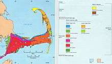
Cape Cod's aquifer consists of six hydrologically independent lenses from which all the towns on the Cape obtain drinking water (except Falmouth, which got 43.5% of its 2015 water from Long Pond).[21][22] Contamination with industrial chemicals and pharmaceutical drugs from septic systems is a concern.[23]

Climate
Although Cape Cod's weather[24] is typically more moderate than inland locations, there have been occasions where Cape Cod has dealt with the brunt of extreme weather situations (such as the Blizzard of 2005 and Hurricane Bob). Because of the influence of the Atlantic Ocean, temperatures are typically a few degrees cooler in the summer and a few degrees warmer in the winter. A common misconception is that the climate is influenced largely by the warm Gulf Stream current; however, that current turns eastward off the coast of Virginia, and the waters off the Cape are more influenced by the cold Canadian Labrador Current. As a result, the ocean temperature rarely gets above 65 °F (18 °C), except along the shallow west coast of the Upper Cape and along the southern coast (Nantucket Sound), where water temperatures can sometimes reach 70 °F (21 °C) or higher.
Cape Cod's climate is also notorious for a delayed spring season, being surrounded by an ocean which is still cold from the winter; however, it is also known for an exceptionally mild fall season (Indian summer), thanks to the ocean remaining warm from the summer. The highest temperature ever recorded on Cape Cod was 104 °F (40 °C) in Provincetown,[25] and the lowest temperature ever was −12 °F (−24 °C) in Barnstable.[26]
The water surrounding Cape Cod moderates winter temperatures nearly enough to extend the humid subtropical climate zone to what could be its northernmost limit in eastern North America, as the majority of Cape Cod is in USDA hardiness zone 7a.[27] Consequently, many subtropical indicator plant species typically found in more southerly latitudes are grown there, including Camellias, Ilex opaca, Magnolia grandiflora and Albizia julibrissin. However, Cape Cod falls below the 72 °F (22 °C) threshold, as the warmest month, July, averages around 68.25 °F (20.14 °C). Therefore, the climate may be better characterized as either a maritime climate or a humid continental climate (particularly on the northern coast of the upper and mid cape, which is somewhat sheltered from the cooler onshore wind to the south).
Precipitation on Cape Cod and the islands of Martha's Vineyard and Nantucket is the lowest in the New England region, averaging slightly less than 40 inches (100 cm) a year (most parts of New England average 42 to 46 inches (110 to 120 cm)). This is due to storm systems which move across western areas, building up in mountainous regions, and dissipating before reaching the coast where the land has leveled out. The region does not experience a greater number of sunny days, however, as the number of cloudy days is the same as inland locales, in addition to increased fog. On average, roughly 27 inches (69 cm) of snow, which is about 17 inches (43 cm) less than Boston, falls in an average winter.
Once every five or six years, a tropical storm, accompanied by very high and potentially damaging winds and heavy rain, will strike the region. About once every 11 or 12 years a hurricane brings damaging winds and storm surges to the region. Several Category 3 storms have struck Cape Cod since record-keeping began, such as the Long Island Express of 1938 and the 1944 Great Atlantic hurricane. Strong Category 2 storms, such as Hurricane Carol of 1954 and Hurricane Bob of 1991 also caused considerable damage. Notable Category 1 storms include Hurricane Edna of 1954 (shortly following Hurricane Carol) and Hurricane Donna of 1960, also Hurricane Irene in 2011, and Hurricane Sandy in 2012. Other notable storms include the Gale of 1815, which would likely have been rated a strong hurricane on the Saffir-Simpson scale, and the so-called "Perfect Storm" of October 31, 1991. The February 2013 nor'easter produced winds in excess of 80 miles per hour (130 km/h) and dropped over 24 inches (61 cm) of snow on some parts of Cape Cod. The storm knocked out power to tens of thousands of Cape Cod residents, some for up to two weeks.
| Climate data for Cape Cod (Chatham, Massachusetts) | |||||||||||||
|---|---|---|---|---|---|---|---|---|---|---|---|---|---|
| Month | Jan | Feb | Mar | Apr | May | Jun | Jul | Aug | Sep | Oct | Nov | Dec | Year |
| Record high °F (°C) | 61 (16) |
57 (14) |
77 (25) |
81 (27) |
88 (31) |
90 (32) |
95 (35) |
93 (34) |
85 (29) |
82 (28) |
68 (20) |
69 (21) |
95 (35) |
| Average high °F (°C) | 37.6 (3.1) |
38.3 (3.5) |
42.8 (6) |
50.5 (10.3) |
59.0 (15) |
68.4 (20.2) |
74.9 (23.8) |
74.7 (23.7) |
69.4 (20.8) |
60.0 (15.6) |
51.7 (10.9) |
42.8 (6) |
55.9 (13.3) |
| Daily mean °F (°C) | 30.9 (−0.6) |
31.7 (−0.2) |
36.7 (2.6) |
45.1 (7.3) |
53.6 (12) |
62.6 (17) |
68.8 (20.4) |
68.7 (20.4) |
63.6 (17.6) |
53.9 (12.2) |
45.6 (7.6) |
36.5 (2.5) |
49.9 (9.9) |
| Average low °F (°C) | 24.1 (−4.4) |
25.0 (−3.9) |
30.7 (−0.7) |
39.6 (4.2) |
48.1 (8.9) |
56.7 (13.7) |
62.7 (17.1) |
62.6 (17) |
57.7 (14.3) |
47.8 (8.8) |
39.6 (4.2) |
30.2 (−1) |
43.8 (6.6) |
| Record low °F (°C) | −6 (−21) |
−4 (−20) |
7 (−14) |
19 (−7) |
33 (1) |
44 (7) |
51 (11) |
47 (8) |
40 (4) |
31 (−1) |
19 (−7) |
0 (−18) |
−6 (−21) |
| Average precipitation inches (mm) | 3.83 (97.3) |
4.24 (107.7) |
4.85 (123.2) |
4.14 (105.2) |
3.81 (96.8) |
3.41 (86.6) |
3.28 (83.3) |
3.20 (81.3) |
3.83 (97.3) |
4.04 (102.6) |
4.03 (102.4) |
4.38 (111.3) |
47.04 (1,194.8) |
| Average snowfall inches (cm) | 8.2 (20.8) |
10.3 (26.2) |
3.5 (8.9) |
0.6 (1.5) |
0 (0) |
0 (0) |
0 (0) |
0 (0) |
0 (0) |
0 (0) |
0.4 (1) |
3.6 (9.1) |
26.6 (67.6) |
| Average precipitation days (≥ 0.01 in) | 12 | 10 | 12 | 11 | 11 | 9 | 8 | 8 | 9 | 10 | 11 | 13 | 125 |
| Source #1: Western Regional Climate Center (normals 1981–2010, extremes and snow 1972–present)[28] | |||||||||||||
| Source #2: NOAA[29] | |||||||||||||
Native population
Cape Cod has been the home of the Wampanoag Native American people for many centuries. They survived off the sea and were accomplished farmers. They understood the principles of sustainable forest management, and were known to light controlled fires to keep the underbrush in check. They helped the Pilgrims, who arrived in the fall of 1620, survive at their new Plymouth Colony.
The Wampanoag lost their lands through continued purchase and expropriation by the English colonists. The documentary Natives of the Narrowland (1993), narrated by actress Julie Harris, shows the history of the Wampanoag people through Cape Cod archaeological sites.
In 1974, the Mashpee Wampanoag Tribal Council was formed to articulate the concerns of those with Native American ancestry. They petitioned the federal government in 1975 and again in 1990 for official recognition of the Mashpee Wampanoag as a tribe. In May 2007, the Wampanoag tribe was federally recognized.[30]
History
Discovery
Cape Cod was a landmark for early explorers. It may have been the "Promontory of Vinland" mentioned by the Norse voyagers (985–1025). The Manomet River area (taken up by the western end of the Cape Cod Canal in the early 20th century) is claimed by some to have been visited by Leif Eiriksson,[31] and a stone wall[32] discovered in Provincetown in 1805 is also claimed to have been built by his younger brother Thorvald Eiriksson around 1007 AD,[33] when the keel of his ship was repaired in the harbor, according to Norse sagas. He was killed later in the same journey, and is said to have been returned to this spot for burial.[34] However, there is no tangible support of the presence of Norse voyagers in Cape Cod,[35] and the view is not generally accepted by archaeologists or historians.[36][37]
Giovanni da Verrazzano approached it from the south in 1524. He named Martha's Vineyard Claudia, after Claude of France, the wife of Francis I of France.[38] In 1525, Portuguese explorer Estêvão Gomes called it Cabo de la Arenas while sailing under the Spanish crown.[39]
In 1602, Bartholomew Gosnold named the tip Cape Cod, the surviving term and the ninth oldest English place-name in the U.S.[40] Samuel de Champlain charted its sand-silted harbors in 1606, and Henry Hudson landed there in 1609. Captain John Smith noted it on his map of 1614, and at last the Pilgrims entered the "Cape Harbor" and – contrary to the popular myth of Plymouth Rock – made their first landing near present-day Provincetown on November 11, 1620. Nearby, in what is now Eastham, they had their first encounter with Native Americans.
Settlement
Cape Cod was among the first places settled by the English in North America. The Cape's fifteen towns developed slowly, aside from Barnstable (1639), Sandwich (1637), and Yarmouth (1639). The final town to be established on the Cape was Bourne in 1884, breaking off from Sandwich.[41] Provincetown was a group of huts until the 18th century. A channel from Massachusetts Bay to Buzzards Bay is shown on Southack's map of 1717. The present Cape Cod Canal was slowly developed from 1870 to 1914. The federal government purchased it in 1928.
The Cape's vegetation was depauperate and trees were scarce by the time that Henry Thoreau saw Cape Cod during his four visits over 1849 to 1857,[42] because of early colonial settlement and intensive land use. The settlers heated by fires, and it took 10 to 20 cords (40 to 80 m³) of wood to heat a home, so they cleared most of Cape Cod of timber early on. They planted familiar crops, but these were unsuited to Cape Cod's thin, glacially derived soils. For instance, much of Eastham was planted to wheat. The settlers practiced burning of woodlands to release nutrients into the soil. Improper and intensive farming led to erosion and the loss of topsoil. Farmers grazed their cattle on the grassy dunes of coastal Massachusetts, only to watch "in horror as the denuded sands 'walked' over richer lands, burying cultivated fields and fences." Dunes on the outer Cape became more common, and many harbors filled in with eroded soils.[43]
By 1800, much of Cape Cod's firewood had to be transported by boat from Maine. The paucity of vegetation was worsened by the raising of merino sheep that reached its peak in New England around 1840. The early industrial revolution occurred through much of Massachusetts and Rhode Island, but it mostly bypassed Cape Cod due to a lack of significant water power in the area. The Cape developed as a large fishing and whaling center as a result, and also because of its geographic position. After 1860 and the opening of the American West, farmers abandoned agriculture on the Cape. By 1950, forests had recovered to an extent not seen since the 18th century.
Modern era

Cape Cod became a summer haven for city dwellers beginning at the end of the 19th century. Improved rail transportation made the towns of the Upper Cape accessible to Bostonians, such as Bourne and Falmouth. At the beginning of the twentieth century, the Northeastern mercantile elite built many large, shingled "cottages" along Buzzards Bay. The relaxed summer environment offered by Cape Cod was highlighted by writers including Joseph C. Lincoln, who published novels and countless short stories about Cape Cod folks in popular magazines such as the Saturday Evening Post and the Delineator.
Guglielmo Marconi made the first transatlantic wireless transmission originating in the United States from Cape Cod, at Wellfleet. The beach below the bluffs where his station was located is now called Marconi Beach. In 1914, he began construction of a new transatlantic wireless receiver station in Chatham and a companion transmitter station in Marion. In 1920, the stations were acquired by RCA and, in 1921, Chatham began operations as a maritime radio station communicating to ships at sea using the callsign WCC. WCC supported the communications of Amelia Earhart, Howard Hughes, Admiral Byrd, and the Hindenburg. Marconi chose Chatham due to its vantage point on the Atlantic Ocean, surrounded on three sides by water. Walter Cronkite narrated a 17-minute documentary in 2005 about the history of the Chatham Station.
Much of the east-facing Atlantic seacoast of Cape Cod consists of wide, sandy beaches. In 1961, a significant portion of this coastline, already slated for housing subdivisions, was made a part of the Cape Cod National Seashore by President John F. Kennedy. It was protected from private development and preserved for public use. Large portions are open to the public, including the Marconi Site in Wellfleet. This is a park encompassing the site of the first two-way transoceanic radio transmission from the United States. (Theodore Roosevelt used Marconi's equipment for this transmission.)
The Kennedy Compound in Hyannis Port was President Kennedy's summer White House during his presidency, and the Kennedy family continues to maintain residences on the compound. President Grover Cleveland maintained a summer home in the Gray Gables section of Bourne. Other notable residents of Cape Cod have included actress Julie Harris, US Supreme Court justice Louis Brandeis, figure skater Todd Eldredge, composer and radio personality Canary Burton, and novelists Norman Mailer and Kurt Vonnegut. Influential natives included patriot James Otis, historian and writer Mercy Otis Warren, jurist Lemuel Shaw, and naval officer John Percival.
On October 28, 2015, a 6-foot-long blue shark was found stranded on a Provincetown beach.[44]
Lighthouses of Cape Cod
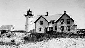
"Lighthouses, from ancient times, have fascinated members of the human race. There is something about a lighted beacon that suggests hope and trust and appeals to the better instincts of mankind."
Cape Cod's coastline has been called an "ocean graveyard" from Chatham to Provincetown, a mere fifty-mile stretch of sea containing over 3,000 shipwrecks, due to its dangerously hidden and constantly moving shoals located just off-shore. Indeed, there have been more than 1,000 wrecks between Truro and Wellfleet alone, including that of the Whydah Gally. The famed pirate ship of "Black Sam" Bellamy was laden with over 4.5 short tons (4.1 metric tons) of treasure when she went down in 1717, killing him and all but two of his 145 fellow sailors.[45]
Beginning in 1797, lighthouses were erected to serve as beacons to warn ships of the danger. Highland Light (or Cape Cod Light) is the oldest and tallest of these, and remains as one of a number of working lighthouses on Cape Cod and the Islands. Many of Cape Cod's earliest lighthouses featured a light tower that was attached directly to – and centered on the roof of – the keeper's dwelling. A stairway to the lantern room was accessible only from the top floor of the house. This came to be known as a Cape Cod style lighthouse, yet today, the only fully intact specimens are on the West Coast.[46]
Most of Cape Cod's lighthouses are operated by the U.S. Coast Guard, with some exceptions such as the Nauset Light, which was relinquished by the Coast Guard in 1996 and is now operated maintained by the Nauset Light Preservation Society under the auspices of Cape Cod National Seashore. These lighthouses are frequently photographed as symbols of Cape Cod.
In 1996, both the Highland Light and Nauset Light were moved because they were each at risk of being lost to the encroaching seas. The Highland Light, then 110 ft (34 m) from the ocean, was moved 450 ft (140 m) to the west, and the Nauset Light, a mere 37 ft (11 m) from the ocean, was moved 300 ft (91 m) west.[47]
The lighthouses of Cape Cod include:
- Upper Cape: Nobska Light, Wing's Neck Light (privately owned), and Cleveland Ledge Light (also private).
- Mid Cape: Sandy Neck Light, Hyannis Harbor Light, Lewis Bay Light (or Hyannis Inner Harbor Light, also private), Bishop and Clerks Light, West Dennis Light (formerly the Bass River Light)
- Lower Cape: Long Point Light, Wood End Light, Race Point Light, Highland Light, Nauset Light, Three Sisters of Nauset, Mayo Beach Light, Billingsgate Island Light, Chatham Light, Monomoy Point Light, Stage Harbor Light
Transportation

Road
Cape Cod is connected to the mainland by a pair of canal-spanning highway bridges, the Bourne and Sagamore that were constructed in the 1930s (replacing a 1912 drawbridge). The two parallel road bridges are four miles apart, with the Bourne Bridge to the west, and the Sagamore to the east. The bridges form a bottleneck, resulting in traffic backups of several miles during the tourist season - especially going on-cape at the beginning of the weekend and off-cape at the end of the weekend.
The entire Cape is roughly bisected lengthwise by U.S. Route 6, locally known as the Mid-Cape Highway and officially as the Grand Army of the Republic Highway.
Air and water
Commercial air service to Cape Cod operates out of Barnstable Municipal Airport and Provincetown Municipal Airport. General aviation airports are:
- Chatham Municipal Airport
- Falmouth Airpark
- Cape Cod Airfield in Marstons Mills, Barnstable
There is one military airport at Otis Air National Guard Base.
There are ferry connections from Boston to Provincetown, as well as from Hyannis and Woods Hole to the islands.
Bus
Cape Cod Regional Transit Authority operates a year-round public bus system comprising three long distance routes and a local bus in Hyannis and Barnstable Village. From mid June until October, additional local routes are added in Falmouth and Provincetown. CCRTA also operates Barnstable County's ADA-required paratransit (dial-a-ride) service, under the name "B-Bus."
Long distance bus service is available through Plymouth and Brockton Street Railway, with regular service to downtown Boston and Logan Airport, as well as less frequent service to Provincetown. Peter Pan Bus Lines also runs long distance service to T.F. Green Airport in Providence, Rhode Island; New York City; and service between Logan Airport, Boston South Station, and Woods Hole.
Rail service
The third bridge over the Cape Cod Canal is a vertical-lift railroad bridge, providing an alternative land transport option.
CapeFlyer is a seasonal passenger rail service between Boston and Hyannis that operates on summer weekends from Memorial Day through Labor Day.
Daily passenger rail service to Cape Cod ended in June 1959. In 1978, the tracks east of South Dennis were abandoned and replaced with the Cape Cod Rail Trail. Another bike path, the Shining Sea Bikeway, was built over abandoned tracks between Woods Hole and Falmouth in 1975, and in 2008 the 7.4-mile long (11.9 km) rail line between Falmouth and North Falmouth was removed and the right-of-way converted into an extension of the Shining Sea Bikeway.
The Cape Cod Central Railroad is a heritage railroad on Cape Cod. The service is primarily tourist-oriented and includes a dinner train over a scenic route between Hyannis and the Cape Cod Canal lasting about 2½ hours round trip. Limited service is also provided to Buzzards Bay and from there to North Falmouth.
Active freight service remains in the Upper Cape area in Sandwich and in Bourne, largely due to a trash transfer station located at Joint Base Cape Cod along the Bourne-Falmouth rail line. In 1986, Amtrak operated a seasonal service in the summer from New York City to Hyannis called the Cape Codder. From 1988, Amtrak and the Massachusetts Department of Transportation increased service to a daily frequency,[48] until service ended in 1996.
Bicycle
Bicycle and pedestrian access to the Cape is possible via a sidewalk on the southbound side of the Bourne Bridge.[49] There are a number of dedicated bike trails and paths around the Cape, including:
- Cape Cod Rail Trail - South Dennis to Wellfleet
- Old Colony Rail Trail - Harwich and Chatham, connecting with the Cape Cod Rail Trail
- Various trails in the Cape Cod National Seashore[50]
- Various trails in Nickerson State Park, connecting with the Cape Cod Rail Trail
- Shining Sea Bikeway - Woods Hole to North Falmouth
- Cape Cod Canal path on both sides of the canal
- Various unpaved Mid-Cape trails[51]
For long-distance biking, the mostly on-road Claire Saltonstall Bikeway connects Cape Cod to the Charles River Bike Path in Boston.
Tourism
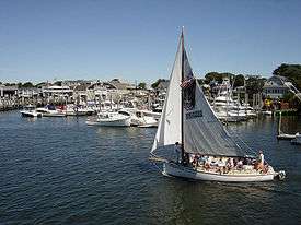
Cape Cod has a year-round population of about 220,000, and it experiences a tourist season each summer, the beginning and end of which can be roughly approximated as Memorial Day and Labor Day, respectively. Many businesses specifically target summer visitors, although the "on season" has been expanding somewhat in recent years due to Indian Summer, reduced lodging rates, the number of people visiting the Cape after Labor Day who have no school-age children, and the elderly—reducing the true "off season" to six or seven months. In the late 20th century, tourists and owners of second homes began visiting the Cape more and more in the spring and fall, softening the definition of the high season and expanding it somewhat.
Provincetown at the tip of Cape Cod berths the original East Coast whale watching fleet (Dolphin Fleet) who patrol the Stellwagen Bank National Marine Sanctuary. The fleet guarantee a whale sighting (mostly humpback whale, fin whale, minke whale, sei whale, and the critically endangered North Atlantic right whale) and is the only federally certified operation qualified to rescue whales. Provincetown has also long been known as an art colony, attracting writers and artists. The town is home to the Cape's most attended art museum, the Provincetown Art Association and Museum.
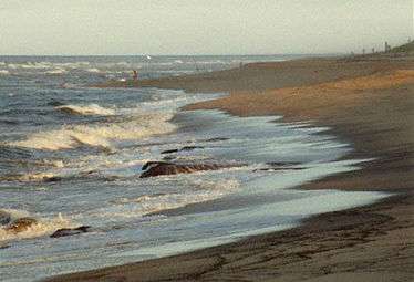
Cape Cod is a popular destination for beachgoers from all over, with 559.6 miles (900.6 km) of coastline. Beaches—both public and private—are easily accessible. The Cape has upwards of sixty public beaches, many of which offer parking for non-residents for a daily fee (in summer). The Cape Cod National Seashore has 40 miles (64 km) of sandy beach and many walking paths.
Cape Cod is also popular for its outdoor activities, such as beach walking, biking, boating, fishing, go-karts, golfing, kayaking, miniature golf, and unique shopping. There are 27 public, daily-fee golf courses and 15 private courses on Cape Cod.[52] Bed and breakfasts or vacation houses are often used for lodging.
Each summer, the Naukabout Music Festival is held at the Barnstable County Fair Grounds located in East Falmouth, typically during the first weekend of August. The festival features local, regional, and national talent, along with food, arts, and family-friendly activities. Some particularly well-known Cape products and industries include cranberries, shellfish (particularly oysters and clams), and lobstering.
Sport fishing
Cape Cod is known around the world as a spring-to-fall destination for sport anglers. Among the species most widely pursued are striped bass, bluefish, bluefin tuna, false albacore (little tunny), bonito, tautog, flounder and fluke. The Cape Cod Bay side of the Cape, from Sandwich to Provincetown, has numerous harbors, saltwater creeks, and shoals that hold bait fish and attract the larger game fish, such as striped bass, bluefish and bluefin tuna.
The outer edge of the Cape, from Provincetown to Falmouth, faces the open Atlantic from Provincetown to Chatham, and then the more protected water of Nantucket and Vineyard Sounds, from Chatham to Falmouth. The bays, harbors and shoals along this coastline also provide a robust habitat for game species, and during the late summer months warm-water species such as mahi-mahi and marlin will also appear on the southern edge of Cape Cod's waters. Nearly every harbor on Cape Cod hosts sport fishing charter boats, which run from May through October.[53]
One of the most popular fishing spots on the East Coast is the Cape Cod Canal. Striped bass, especially, in season attract anglers from far and wide. A large part of the attraction involves ease of access. Ample free parking exists all along the waterway, and the banks are a short walk from one's vehicle. This reduces fishing to the basics – a pole and a few lures.
Sports
The Cape has nine amateur baseball franchises playing within Barnstable County in the Cape Cod Baseball League. The Wareham Gatemen also play in the Cape Cod Baseball League in nearby Wareham in Plymouth County. The league's beginning is unsettled, even fanciful. Without any basis whatsoever, some claim a start date of 1875. However, the first Cape Cod League formed in Sandwich in 1910. It did not last. Three years later - in 1913 - another Cape Cod Baseball League organized. This venture lasted two years. In 1916, a third attempt at league play barely got off the ground. Then, in 1923, an initial four teams met in Hyannis and started a successful federation along the lines of the present league. Outstanding players from throughout the region competed until the war effort led to a shutdown in 1940. In 1946, the local town teams from the prewar County Twilight League and Lower Cape Cod League organized under the Cape Cod Baseball League banner. As the years passed, local players were moved aside by outside college stars. Finally, in 1963, the league became a wholly summer collegiate circuit sanctioned by the National Collegiate Athletic Association with some Major Leagues financial support.[54] The current teams in the league are the Bourne Braves, Brewster Whitecaps, Chatham Anglers (formerly the Chatham Athletics), Cotuit Kettleers, Falmouth Commodores, Harwich Mariners, Hyannis Harbor Hawks (formerly the Hyannis Mets), Orleans Firebirds (formerly the Orleans Cardinals), Wareham Gatemen and the Yarmouth–Dennis Red Sox. MLB scouts frequent the games in the summer, looking for stars of the future.
Along with the Cape Cod Baseball League and the new Junior Hockey League team, the Cape Cod Islanders, many high school players are being recruited as well. Barnstable and Harwich have each sent multiple players to Division 1 colleges for baseball. Harwich has also won three state titles since 1996 (1996, 2006, 2007). Bourne and Sandwich, rivals in hockey, have each won state championships recently, Bourne in 2004 and Sandwich in 2007. Nauset, Barnstable, and Martha's Vineyard are also state hockey powerhouses. Barnstable and Falmouth hold the title of having one of the longest Thanksgiving football rivalries in the country. The teams have played each other every year on Thanksgiving since 1895. High school football teams on the Cape have also recently become successful and the region has also become a hot-spot for college recruiting. In 2011, four high school football teams from the Cape won state championships in their respective divisions; Dennis-Yarmouth (Division 2A), Bourne (Division 3A), Mashpee (Division 4), and Nantucket (Division 5). Also, numerous other Cape schools have made appearances in the football state championship game recently, including Barnstable in 2012, Martha's Vineyard in 2008, Cape Cod Tech in 2006, and Dennis-Yarmouth in 2013. The Bourne and Barnstable girls' volleyball teams are two of the best teams in the state and Barnstable is considered one of the best programs in the country. Bourne won the state title in 2003 and 2007, and Barnstable has won 12 Division 1 state titles in the past 13 years and has won the state title the three years in a row (2011–2013). In the 2010 cross country season, Sturgis Charter Public School's Division 4 cross country team remained virtually unbeaten throughout their running season.
The Cape is home to the Cape Cod Frenzy, a team in the American Basketball Association.
Soccer on Cape Cod is represented by the Cape Cod Crusaders, playing in the USL Premier Development League (PDL) based in Hyannis. In addition, a summer Cape Cod Adult Soccer League (CCASL) is active in several towns on the Cape.
Cape Cod is the home of the Cape Cod Cubs, a new junior league hockey team that is based out of Hyannis at the new community center being built on Bearses Way.
The end of each summer is marked with the running of the Falmouth Road Race, held on the third Saturday in August. It draws about 10,000 runners to the Cape and showcases the finest runners in the world (mainly for the large purse that the race is able to offer). The race is 7.2 miles (11.6 km) long, which is a non-standard distance. The reason for the unusual distance is that the man who thought the race up (Tommy Leonard) was a bartender who wanted a race along the coast from one bar (The Cap'n Kidd in Woods Hole) to another (The Brothers Four in Falmouth Heights). While the bar in Falmouth Heights is now the British Beer Company, the race still starts at the front door of the Cap'n Kidd in Woods Hole and now finishes at the beach in Falmouth Heights. Prior to the Falmouth race is an annual 5-mile (8.0 km) race through Brewster called the Brew Run, held early in August.
Education
Each town usually consists of a few elementary schools, one or two middle schools and one large public high school that serves the entire town. Exceptions to this include Dennis-Yarmouth Regional High School located in Yarmouth, which serves the two towns in its name, Monomoy Regional High School, located in Harwich and serving that town as well as Chatham, and Nauset Regional High School in Eastham, which serves the towns of Brewster, Orleans, Eastham, Wellfleet, Truro, and Provincetown. Bourne High School is the public school for students residing in the town of Bourne, which is gathered from villages in Bourne, including Sagamore, Sagamore Beach, and Buzzards Bay. Barnstable High School is the largest high school and is known for its girls' volleyball team which have been state champions a total of 12 times. Barnstable High School also boasts one of the country's best high school drama clubs which were awarded a contract by Warner Bros. to create a documentary in webisode format based on their production of The Wizard of Oz. Sturgis Charter Public School is a public school in Hyannis which was featured in Newsweek magazine's "Best High Schools" ranking. It ranked 28th in the country and 1st in the state of Massachusetts in the 2009 edition and ranked 43rd and 55th in the 2008 and 2007 edition, respectively. Sturgis offers the International Baccalaureate Diploma Programme in their junior and senior year and is open to students from as far as Plymouth. The Cape also contains two vocational high schools. One is the Cape Cod Regional Technical High School in Harwich, and the other is Upper Cape Cod Regional Technical High School in Bourne.
In 1976 the Cape schools and districts petitioned the Massachusetts Legislature to create an educational collaborative, the Cape Cod Collaborative, to facilitate cooperation and efficiency in providing gifted and talented, and special needs programs. With locations in Osterville and Bourne the Cape Cod Collaborative provides transportation services, professional development, autism support, developmental training, itinerant services and an alternative education program. Each summer, in cooperation with the Massachusetts Maritime Academy, it operates a gifted and talented science-based program for students from around the Cape.
Mashpee High School is home to the Mashpee Chapter of SMPTE, the Society of Motion Picture and Television Engineers. This chapter is the first and only high school chapter in the world to be a part of this organization and has received much recognition within the Los Angeles broadcasting industry as a result.
In addition to public schools, Cape Cod has a wide range of private schools. The town of Barnstable has Trinity Christian Academy, Cape Cod Academy, St. Francis Xavier Preparatory School, and Pope John Paul II High School. Bourne offers the Waldorf School of Cape Cod, Orleans offers the Lighthouse Charter School for elementary and middle school students, and Falmouth offers Falmouth Academy. Riverview School is located in East Sandwich and is a special co-ed boarding school which serves students as old as 22 who have learning disabilities. Another specialized school is the Penikese Island School, located in the Elizabeth Islands off southwestern Cape Cod, which serves struggling and troubled teenage boys.
Cape Cod contains three institutions of higher education. One is the Cape Cod Community College located in West Barnstable. The second is Massachusetts Maritime Academy in the village of Buzzards Bay. Massachusetts Maritime Academy is the oldest continuously operating maritime college in the United States. The third is Bridgewater State University, which recently opened a satellite campus in South Yarmouth in January 2015. The school will provide 40 undergraduate and graduate courses leading to the completion of bachelor's degree and master's degree programs in Early Childhood Education, Educational Leadership, Secondary Education, Reading, and Special Education. The campus will also offer Certificate Programs in Business and Social Work. Beginning in the Summer 2015, the campus will begin to offer undergraduate credit courses in History.[55][56]
In popular culture
The Cape Codder cocktail is named after the peninsula; both are notable for cranberry. Cape Cod also generated a distinctive Cape style house and Cape lighthouse.
The virtues of Cape Cod are extolled in the song Old Cape Cod.
Norman Mailer's 1984 noir thriller and murder mystery novel Tough Guys Don't Dance is set in Provincetown on Cape Cod.
According to Cole Porter's song "Let's Do It," "cold Cape Cod clams 'gainst their wish do it."
In 1996, the Commonwealth of Massachusetts allowed the creation of a "Cape & Islands" registration plate.[57]
See also
References
Notes
- 1 2 United States Coast Guard. "Local Cape Cod Information".
- ↑ "The Cape Cod Commission Act". Cape Cod Commission. 1989. Retrieved 5 March 2014.
- ↑ "Census: Cape Cod losing population - News - capecodtimes.com - Hyannis, MA". Capecodtimes.com. 2011-03-23. Retrieved 2016-05-13.
- ↑ "Barnstable County Massachusetts QuickFacts from the US Census Bureau". Quickfacts.census.gov. Retrieved 2016-05-13.
- ↑ See the tables on Politics of Massachusetts, Barnstable County, Dukes County, and Nantucket
- ↑ Vuilleumier, Marion R. (2003). Sagamore Beach. Arcadia Publishing. p. 7. ISBN 9780738511832.
- ↑ Cape Cod Commission. "Comprehensive Economic Development Strategy (CEDS)". Retrieved May 17, 2010.
- ↑ "The Opening of the Cape Cod Canal". 46. Bulletin of the American Geographical Society. 1914: 832–834. doi:10.2307/200951.
- ↑ Cape Cod at Encyclopædia Britannica.
- 1 2 "Forms of Municipal Government for each community in Massachusetts" (PDF). Massachusetts Municipal Association. July 2011. Retrieved 6 May 2013.
- ↑ "Dates of Incorporation and/or Establishing City Form of Government" (PDF). Massachusetts Department of Housing and Community Development. 13 November 2008. Retrieved 6 May 2013.
- ↑
- ↑ "Aptucxet Trading Post Museum |". Bournehistoricalsociety.org. Retrieved 2016-05-13.
- ↑ Barnstable, Massachusetts GIS Maps (Retrieved December 21, 2006 E911 Map – Town of Barnstable. Town.barnstable.ma.us.
- ↑ Dennis town website (Accessed: May 3, 2009) Archived March 24, 2010, at the Wayback Machine.
- ↑ Leatherman, Stephen. "DrBeach.org – America's Best Beaches 2007". Dr.Beach.Org. Archived from the original on May 18, 2007. Retrieved June 11, 2007.
- ↑ Brigham (1920), p. 206.
- ↑ Brigham, Sc.D, Albert Perry (1920). Cape Cod and the Old Colony. New York: G.P. Putnam's Sons. p. 132.
- ↑ "Provincetown Spit, Cape Cod, Massachusetts". NASA Earth Observatory. Retrieved May 2, 2006.
- ↑ Oldale, Robert N. "Coastal Erosion on Cape Cod: Some Questions and Answers". WoodsHole.er.usgs.gov. Retrieved November 30, 2007.
- ↑ http://www.mass.gov/eea/docs/eea/water/assess-rpt-capecod.pdf
- ↑ http://www.falmouthmass.us/depart.php?depkey=water
- ↑ http://www.silentspring.org/research-area/water-research
- ↑ Retrieved May 3, 2009 Archived April 19, 2011, at the Wayback Machine.
- ↑ "Provincetown, Massachusetts Travel Weather Averages". Weatherbase. Retrieved 2016-05-13.
- ↑ "Yarmouth, Massachusetts Travel Weather Averages". Weatherbase. Retrieved 2016-05-13.
- ↑ National Arboretum – USDA Plant Hardiness Zone Map. Usna.usda.gov (January 24, 2012).
- ↑ "General Climate Summary Tables". Western Regional Climate Center. Retrieved February 19, 2013.
- ↑ "NowData - NOAA Online Weather Data". National Oceanic and Atmospheric Administration. Retrieved February 19, 2015.
- ↑ Stephanie Vosk (May 25, 2007). "Wampanoag tribe wins recognition". Cape Cod Times. Retrieved June 5, 2007.
- ↑ "Aptucxet Trading Post, Bourne Historical Society, Bourne, Cape Cod, MA". Bourne Historical Society. Retrieved Feb 27, 2011.
- ↑ "The Norse Wall House on Wikimapia". Retrieved February 13, 2007.
- ↑ "The Norse Wall". capelinks.com. Retrieved February 13, 2007.
- ↑ Jennings, Herman A. (1890). Provincetown, or, odds and ends from the tip end. Yarmouthport, Massachusetts: F. Hallett, Printer. pp. 9–14.
- ↑ Tager, Jack and Jennifer L. Herman (2008). Massachusetts Encyclopedia. North American Book Dist LLC. p. 280. ISBN 9781878592651.
- ↑ Bailey, Anthony (1999). The Coast of Summer: Sailing New England Waters from Shelter Island to Cape Cod. Sheridan House, Inc. p. 154. ISBN 9781574090741.
- ↑ Stockwell, Mary (2006). A Journey Through Maine. Gibbs Smith. p. 48. ISBN 9781423624165.
- ↑ Baer, Chris. "HISTORY OF MARTHA'S VINEYARD". Historical Records of Dukes County, Massachusetts. Retrieved June 27, 2009.
- ↑ David J. Weber (1992). The Spanish frontier in North America. Yale University Press. p. 36. ISBN 978-0-300-05917-5. Retrieved March 18, 2012.
- ↑ Stewart, George (1945). Names on the Land: A Historical Account of Place-Naming in the United States. New York: Random House. p. 27.
- ↑ Deyo, Simeon, ''The History of Barnstable County, NY, 1890'', Retrieved May 3, 2009. Plymouthcolony.net (August 6, 1996).
- ↑ Thoreau, Henry David, Cape Cod, 1865, http://thoreau.eserver.org/capecd00.html Retrieved May 3, 2009
- ↑ "Reflections in Bullough's Pond", Conservation Matters Archived October 4, 2011, at the Wayback Machine., Summer 2000
- ↑ "Public comforts 6-foot-long blue shark stranded on a Cape Cod beach". Boston.com. Retrieved 2015-11-18.
- ↑ "Shipwrecks – Cape Cod National Seashore". National Park Service. Retrieved 30 January 2013.
- ↑ "Long Point, MA". LighthouseFriends.com. Retrieved 15 February 2014.
- ↑ "Lighthouse Moves – Cape Cod National Seashore". National Park Service. Retrieved 30 January 2013.
- ↑ Kolleth, Michael (May 29, 1988). "Daily Rail Service to Cape is Returning". New York Times.
- ↑ "Bourne Bridge (MA 28)". Bostonroads.com. Retrieved 2016-05-13.
- ↑ "Cape Cod : Bike trails, safety tips, and guidelines" (PDF). Nps.gov. Retrieved 2016-05-13.
- ↑ "Road Cycling, Off Road Riding, ATB, MTB, Biking, Bicycle Trails On-road and Off-road". Cape Cod Bike Guide. Retrieved 2016-05-13.
- ↑ "Archived copy". Archived from the original on July 4, 2008. Retrieved February 6, 2016.
- ↑ "Archived copy". Archived from the original on January 16, 2010. Retrieved January 18, 2010.
- ↑ Ellis, James H. "Cape Cod League a Talent Showcase." The Baseball Research Journal 15 (1986): 56-59.
- ↑ "Archived copy". Archived from the original on December 16, 2014. Retrieved December 13, 2014.
- ↑ "BSU Cape Cod | Bridgewater State University". Bridgew.edu. Retrieved 2016-05-13.
- ↑ "Keep the sand in your shoes all year long". Capeandislandsplate.com. Retrieved 2016-05-13.
Sources
Geologic History of Cape Cod, Massachusetts, by the United States Geological Survey (USGS)
Further reading
- Cumbler, John T. Cape Cod: An Environmental History of a Fragile Ecosystem. Amherst, MA: University of Massachusetts Press, 2014.
- Freeman, Frederick. (1860). The History of Cape Cod: The Annals of Barnstable County and of Its Several Towns (Vol. 1). Harvard University.
- Freeman, Frederick. (1862). The History of Cape Cod: The Annals of Barnstable County and of Its Several Towns (Vol. 2). Harvard University.
- LeBlanc, D.R. (1986). Ground-water resources of Cape Cod, Massachusetts [Hydrologic Investigations Atlas HA-692]. Reston, Va.: U.S. Department of the Interior, U.S. Geological Survey.
- Massey, A.J., C.S. Carlson, and D.R. LeBlanc. (2006). Ground-water levels near the top of the water-table mound, western Cape Cod, Massachusetts, 2002–04 [Scientific Investigations Report 2006-5054]. Reston, VA: U.S. Department of the Interior, U.S. Geological Survey.
- Masterson, J.P. and J.W. Portnoy. (2005). Potential changes in ground-water flow and their effects on the ecology and water resources of the Cape Cod National Seashore, Massachusetts [General Information Product 13]. Reston, VA: U.S. Department of the Interior, U.S. Geological Survey.
- Walter, D.A. and A.T. Whealan. (2005). Simulated water sources and effects of pumping on surface and ground water, Sagamore and Monomoy flow lenses, Cape Cod, Massachusetts [Scientific Investigations Report 2004-5181]. Reston, VA: U.S. Department of the Interior, U.S. Geological Survey.
External links
- Cape Cod Chamber of Commerce
- "Geologic History of Cape Cod, Massachusetts", U.S. Geological Survey
 Ripley, George; Dana, Charles A., eds. (1879). "Cape Cod". The American Cyclopædia.
 |
Plymouth County | Cape Cod Bay | Gulf of Maine | |
| Cape Cod Canal | |
Atlantic Ocean | ||
| ||||
| | ||||
| Buzzards Bay | Nantucket Sound | Atlantic Ocean |
Boston (capital) | |
| Topics |
|
| Society | |
| Regions | |
| Counties | |
| Cities |
|