Legislative districts of Quezon City
 |
| This article is part of a series on the politics and government of the Philippines |
|
Legislature
|
|
Constitutional Commissions |
The Legislative Districts of Quezon City are the representations of Quezon City in the various national legislatures of the Philippines. The city is currently represented in the lower house of the Congress of the Philippines through its first, second, third, fourth, fifth, and sixth districts.
History
From its creation in 1939 to 1972, Quezon City was represented as part of Rizal Province, with the western areas that formerly belonged to Caloocan, Mandaluyong and San Juan voting as part of that province's first district, and the eastern areas that formerly belonged to Marikina, Rodriguez, Pasig and San Mateo voting in the second district.
In the disruption caused by the Second World War, Quezon City was incorporated into the City of Greater Manila on January 1, 1942 by virtue of Manuel Quezon's Executive Order No. 400 as a wartime emergency measure. Greater Manila was represented by two delegates in the National Assembly of the Japanese-sponsored Second Philippine Republic: one was the city mayor (an ex officio member), while the other was elected through a city-wide assembly of KALIBAPI members during the Japanese occupation of the Philippines. Upon the restoration of the Philippine Commonwealth in 1945, Quezon City's divided representation between the two districts of Rizal was retained; this remained so until 1972.
The city was represented in the Interim Batasang Pambansa as part of Region IV from 1978 to 1984. Quezon City residents first elected representatives separate from Rizal in the 1984 election, where four representatives, elected at-large, represented the city at the Regular Batasang Pambansa.
Quezon City was reapportioned into four congressional districts under the new Constitution[1] which was proclaimed on February 11, 1987. It elected members to the restored House of Representatives starting that same year.
By virtue of Republic Act No. 10170[2] approved on July 2, 2012, the fifth and sixth districts were created out of the second district. Residents of the two new districts began to elect their own representatives beginning in the 2013 elections.
1st District
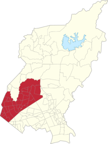
- Barangays: Alicia, Bagong Pag-asa, Bahay Toro, Balingasa, Bungad, Damar, Damayan, Del Monte, Katipunan, Lourdes, Maharlika, Manresa, Mariblo, Masambong, N.S. Amoranto (Gintong Silahis), Nayong Kanluran, Paang Bundok, Pag-ibig sa Nayon, Paltok, Paraiso, Phil-Am, Project 6, Ramon Magsaysay, Saint Peter, Salvacion, San Antonio, San Isidro Labrador, San Jose, Santa Cruz, Santa Teresita, Santo Cristo, Santo Domingo, Siena, Talayan, Vasra, Veterans Village, West Triangle
- Area: 18.30 km²
- Population (2010): 414,039
| Period | Representative |
|---|---|
1987–1992 |
|
1992–1995 | |
1995–1998 |
|
1998–2001 | |
2001–2004 | |
2004–2007 |
|
2007–2010 | |
2010–2013 | |
2013–2016 |
|
2016–2019 |
|
- ^1 Died January 11, 2003.
2nd District
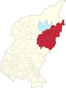
- Barangays: Bagong Silangan, Batasan Hills, Commonwealth, Holy Spirit and Payatas
- Area:
- Population (2010): 635,967
| Period | Representative |
|---|---|
2013–2016 |
|
2016–2019 |
1987–2013
- Barangays: Apolonio Samson, Baesa, Bagbag, Bagong Silangan, Balong Bato, Capri, Commonwealth, Batasan Hills, Culiat, Fairview, Greater Lagro, Gulod, Holy Spirit, Kaligayahan, Nagkaisang Nayon, New Era, North Fairview, Novaliches Proper, Pasong Putik Proper, Pasong Tamo, Payatas, San Agustin, San Bartolome, Sangandaan, Santa Lucia, Santa Monica, Sauyo, Talipapa, Tandang Sora, Unang Sigaw
| Period | Representative |
|---|---|
1987–1992 |
|
1992–1995 |
|
1995–1998 | |
1998–2001 | |
2001–2004 |
|
2004–2007 |
|
2007–2010 | |
2010–2013 |
3rd District

- Barangays: Amihan, Bagumbuhay, Bagumbayan, Bayanihan, Blue Ridge A, Blue Ridge B, Camp Aguinaldo, Claro, Dioquino Zobel, Duyan-Duyan, E. Rodriguez, East Kamias, Escopa I, Escopa II, Escopa III, Escopa IV, Libis, Loyola Heights, Mangga, Marilag, Masagana, Matandang Balara, Milagrosa, Pansol, Quirino 2-A, Quirino 2-B, Quirino 2-C, Quirino 3-A, Saint Ignatius, San Roque, Silangan, Socorro, Tagumpay, Ugong Norte, Villa Maria Clara, West Kamias, White Plains
- Area: 23.36 km²
- Population (2010): 307,638
| Period | Representative |
|---|---|
1987–1992 |
|
1992–1995 |
|
1995–1998 |
|
1998–2001 | |
2001–2004 |
|
2004–2007 |
|
2007–2010 | |
2010–2013 |
|
2013–2016 | |
2016–2019 |
4th District
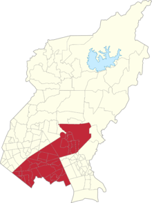
- Barangays: Bagong Lipunan ng Crame, Botocan, Central, Kristong Hari, Damayang Lagi, Doña Aurora, Doña Imelda, Doña Josefa, Don Manuel, East Triangle, Horseshoe, Immaculate Conception, Kalusugan, Kamuning, Kaunlaran, Krus na Ligas, Laging Handa, Malaya, Mariana, Obrero, Old Capitol Site, Paligsahan, Pinyahan, Pinagkaisahan, QMC, Roxas, Sacred Heart, San Isidro Galas, San Martin de Porres (Cubao), San Vicente, Santo Niño, Santol, Sikatuna Village, South Triangle, Tatalon, Teachers Village East, Teachers Village West, U.P. Campus, U.P. Village, Valencia
- Area: 25.17 km²
- Population (2010): 428,555
| Period | Representative |
|---|---|
1987–1992 |
|
1992–1995 |
|
1995–1998 | |
1998–2001 | |
2001–2004 |
|
2004–2007 | |
2007–2010 | |
2010–2013 |
|
2013–2016 | |
2016–2019 |
5th District
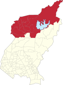
- Barangays: Bagbag, Capri, Fairview, Greater Lagro, Gulod, Kaligayahan, Nagkaisang Nayon, North Fairview, Novaliches Proper, Pasong Putik Proper, San Agustin, San Bartolome, Santa Lucia, Santa Monica
- Area:
- Population (2010): 488,172
| Period | Representative |
|---|---|
2013–2016 |
|
2016–2019 |
6th District
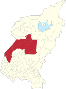
- Barangays: Apolonio Samson, Baesa, Balon-Bato, Culiat, New Era, Pasong Tamo, Sangandaan, Sauyo, Talipapa, Tandang Sora, Unang Sigaw
- Area:
- Population (2010): 487,349
| Period | Representative |
|---|---|
2013–2016 |
|
2016–2019 |
At-Large (defunct)
| Period | Assemblyman |
|---|---|
1984–1986 |
|
References
- Philippine House of Representatives Congressional Library
- ↑ "1987 Constitution of the Philippines - Apportionment Ordinance". Retrieved June 13, 2016.
- ↑ Congress of the Philippines (July 2, 2012). "Republic Act No. 10170". Retrieved June 13, 2016.