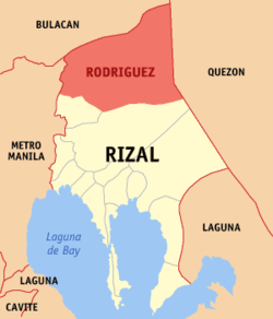
Rodriguez, Rizal
| Rodriguez Montalban | |
|---|---|
| Municipality | |
 | |
 Map of Rizal showing the location of Rodriguez | |
.svg.png) Rodriguez Location within the Philippines | |
| Coordinates: 14°43′N 121°07′E / 14.717°N 121.117°ECoordinates: 14°43′N 121°07′E / 14.717°N 121.117°E | |
| Country | Philippines |
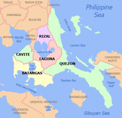
| Region | Calabarzon (Region IV-A) |
| Province | Rizal |
| District | 2nd District of Rizal |
| Founded (as Montalban) | 1909 |
| Renamed as Rodriguez (Batas Pambansa Blg. 275) | November 12, 1982 |
| Named for | Eulogio Rodriguez, Sr. |
| Barangays | 11 |
| Government[1] | |
| • Mayor | Cecilio C. Hernandez |
| Area[2][3] | |
| • Total | 312.70 km2 (120.73 sq mi) |
| Population (August 2015)[4] | |
| • Total | 369,222 |
| • Density | 1,200/km2 (3,100/sq mi) |
| Time zone | PST (UTC+8) |
| ZIP code | 1860 |
| Dialing code | +63 (0)2 |
| Income class | 1st |
| Website |
www |
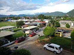
Rodriguez is a first-class, urban municipality in the province of Rizal, Philippines. It is the northernmost town in the province and comes after San Mateo, Rizal, and Quezon City coming from Metro Manila. The town is located on the slopes of the Sierra Madre mountain range and features many resorts; it is also the largest town in Rizal province with an area of 312.70 km². It borders San Mateo, Rizal and Antipolo City, Rizal on the south, Norzagaray, Bulacan and San Jose Del Monte, Bulacan on the north, Quezon City on the west and General Nakar, Quezon on the east.
Montalban, a common name for the municipality up to the present, was its official name from its founding in 1909 until 1982 when the Batasang Pambansa officially renamed it Rodriguez in honor of Eulogio Rodriguez, Sr., a native of the municipality who served as Senate President.
As of the 2015 census, Rodriguez has a population of 369,222.[4]
Rodriguez is one of the richest municipalities in the Philippines, ranking eighth in 2007 with an annual income of ₱310 million.
The legend of Bernardo Carpio is said to have happened in the mountains of the town.
Geography
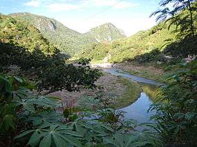
Rodriguez is a town of mountains. From its north to south, a series of sloping ridges, hills and mountains ranges adorn the town. In fact, around 27% or the town is occupied by mountains and slopes. The town's highest peak is Mt. Irid, towering 1,469 meters above mean and sea level.
The province of Rizal spans for 1,175.8 square kilometers. Rodriguez makes up 26.6% on the entire province of Rizal, housing 11 barangays. The land mass of Rodriguez is big enough to be an ideal place for many purposes, such as agriculture, commerce such as the Avilon Zoo, and hiking and climbing spots of Wawa Gorge, relocation of communities (having a strategic position east of Rizal, and a lot of areas where low-cost housing projects can be put up), subdivision areas for either low-,mid-,high-cost housing, and also for special uses (such as the landfill).
Elevation and slope
The Municipality of Rodriguez is generally very rough in topography, with 83% of its total land area composed of upland areas, hills and mountain ranges. The remaining 17% lowlying terrain and rolling lands are found at the south-western portion of the municipality, along with the northern portions of the Municipality of San Mateo.
This gently rolling to rolling slopes comprises the Marikina River Valley, where water from higher elevations drain towards the Marikina River and its tributaries at the south-western portion of the municipality. Elevations at these western lowlands range from 10 to 30 meter above sea level. The western portion of the flatlands gently rises towards the west, which is part of Quezon City.
The mountainous regions of the Municipality of Rodriguez are found at the central and eastern areas, with sleepy sloping ridges and mountain ranges, traversing north to south. The terrain in these mountain ranges has slopes ranging from 30–50%. Very steep hills and mountains have slopes greater than 50%. Rolling to hilly areas 18–30% in slope can also be found. These high elevations are drained by several major rivers, namely the Tanay, Puray, and Rodriguez Rivers.
Barangays
Rodriguez is politically subdivided into 11 barangays (8 urban, 3 rural):[5]
- Balite
- Burgos
- Geronimo
- Macabud
- Manggahan
- Mascap
- Puray
- Rosario
- San Isidro
- San Jose
- San Rafael
History
Rodriguez was founded in World War II. Japanese pilots bombed Montalban (now. Rodriguez) in December 1941. The Japanese soldiers occupied Montalban (now. Rodriguez), Rizal in 1942. The local guerrilla fighters began the encounter conflicts and insurgencies around the town municipalities and began the battling sieges and they aided by the ongoing Filipino troops under the Philippine Commonwealth Army units was become attack by the Imperial Japanese force from 1942 to 1945 and until the aftermath of the local guerrillas retreats the Japanese going to town before to liberation. In 1945, combined Filipino and American ground troops including the local recognized guerrillas liberated Montalban (now. Rodriguez) and defeating Japanese soldiers and aftermath in World War II.
Demographics
| Population census of Rodriguez | ||
|---|---|---|
| Year | Pop. | ±% p.a. |
| 1980 | 41,859 | — |
| 1990 | 67,074 | +4.83% |
| 1995 | 79,668 | +3.28% |
| 2000 | 115,169 | +8.22% |
| 2007 | 223,594 | +9.58% |
| 2010 | 280,904 | +8.66% |
| 2015 | 369,222 | +5.34% |
| Source: National Statistics Office[4] | ||
Transportation
The main transportation used in the municipality were jeepneys, tricycles, SUVs, and buses. There are jeepneys that ply through the towns of San Mateo, Marikina and Cubao via Marcos Highway in Quezon City, some ply the route that leads to Philcoa in Quezon City via Batasan Road in San Mateo, others connect Rodriguez to Litex Road in Quezon City. The Marikina Auto Line Transport Corporation (MALTC) buses is the only one that regularly travels to farther places like Makati and Parañaque. SUV's ply the routes to Cubao in Quezon City and Sta. Lucia Grand Mall in Cainta. Formerly there was a single railway line of the Philippine National Railways that goes up to Baranggay Balitè. It has been long dismantled.
It is known that 'patok' jeepneys originated from this town wayback during the 80's. These jeepneys are known for their notoriety on the road, despite being dangerous they are popular among the passengers hence the name patók which means 'popular'. They still ply to this town up to this day, most plying the Montalban-Cubao route via Marcos Highway. These jeepneys have already spread throughout the Rizal province as well in Marikina City ever since.
Municipal mayors
| No | Entered office | Exited office | Name |
|---|---|---|---|
| 1 | 1909 | 1916 | Eulogio Rodriguez |
| 2 | 1916 | 1919 | Eusebio Manuel |
| 3 | 1919 | 1928 | Gregorio Bautista |
| 4 | 1928 | 1932 | Jose Rodriguez |
| 5 | 1932 | 1936 | Roman Reyes |
| 6 | 1936 | 1940 | Jacinto Bautista |
| 7 | 1941 | 1943 | Francisco Rodriguez |
| 8 | 1943 | 1944 | Federico San Juan |
| 9 | 1945 | 1945 | Gavino Cruz |
| 10 | 1946 | 1947 | Catalino Bautista |
| 11 | 1947 | 1947 | Macario Bautista |
| 12 | 1948 | 1959 | Benigno Liamzon |
| 13 | 1960 | 1960 | Guillermo Cruz Sr. |
| 14 | 1960 | 1984 | Teodoro Rodriguez |
| 15 | 1984 | 1987 | Pablo Adriano |
| 16 | 1988 | 1993 | Angelito Manuel |
| 17 | 1993 | 1995 | Ernesto Villanueva |
| 18 | 1995 | 1998 | Pedro Cuerpo |
| 19 | 1998 | 2001 | Rafaelito San Diego |
| 20 | 2001 | 2010 | Pedro Cuerpo |
| 21 | 2010 | Incumbent | Cecilio Hernandez |
Tourist attractions
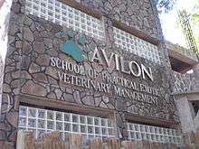
- Avilon Zoo
- Pamitinan Cave
- Wawa Dam
- Noah's Park
- Puray Falls
- Mt.Balagbag
- Mt. Sipit Ulang
- Mt.Pamitinan
Hospitals
- H Vill Hospital
- N. Medcare Hospital
- St. Mark Hospital
- San Jose Maternity and Lying-in Hospital
- Montalban Infirmary
- Casimiro Ynares Memorial Medical Center
Education
There are numerous elementary and high schools, both public and private, offering primary, secondary and tertiary education in the town of Rodriguez. There are also colleges and institutions that offer graduate and undergraduate programs in town.
Elementary schools
- Amityville Elementary School
- Burgos Elementary School
- Christ The Foundation Christian Academy
- Eastbridge School
- EBBC Christian Academy
- Eulogio Rodriguez Elementary School
- Geronimo Elementary School
- Infant Jesus Learning Academy
- Jess Christian Academy
- Kasiglahan Village Elementary School
- Little Guardian Learning Center
- Living Epistle Christian Academy
- Lord Most High Christian School
- Macabud Elementary School
- Manggahan Elementary School
- MelvinShire School
- Puray Elementary School
- Rodriguez Heights Elementary School
- Roosevelt College Elementary School
- San Jose Elementary School
- San Rafael Elementary School
- Southville 8C Elementary School
- St. Anne Child Study Center
- St. Joseph College Grade School
- Jesus Christ Saves Global Outreach Christian Academy
- Tagumpay Elementary School
- Virgen del Pilar Elementary School
- Wawa Elementary School
- Malasya-Uyungan Elementary School
- San Isidro Elementary School
High schools
- Burgos National High School
- Christ The Foundation Christian Academy
- Divine Saviour Montessori School
- Eastern Valley School
- Gen. Licerio Geronimo Memorial National High School
- Holy Family Montessori
- Jesus Christ Saves Global Outreach Christian Academy (JCSGO)
- Kasiglahan Village National High School
- Macabud National High School
- Macaingalan National High School
- Manggahan National High School
- Maranatha Christian School
- Mascap National High School
- Montalban Heights National High School
- Puray National High School
- Roosevelt College High School
- San Isidro National High School
- San Jose National High School
- Southville 8C National High School
- St. Joseph's Colleges' Center for Positive Futures
- St. Mary Magdalene Academy
- Tagumpay National High School
- Valley High Academy
- Virgen del Pilar High School
- Wawa National High School
Senior High Schools
- Kasiglahan Village Senior High School
- Roosevelt College Senior High School
- San Isidro Senior High School
- San Jose - Litex Senior High School
- Southville 8B Senior High School
Colleges and institutions
- Asian Institute of Computer Studies - Montalban
- Froebellian College of Science and Technology
- Gerald's School of Science and Technology
- St. Joseph's College of Quezon City
- Pamantasan ng Montalban
- University of Rizal System (URS)
Houses of charities
There are houses of charities located in the town.
- Cottolengo Filipino[6] – A non-stock, non-profit and non-government organizations licensed and accredited by the Department of Social Welfare and Development (DSWD). Its aim is to serve the most poor, abandoned, neglected, surrendered persons with disabilities.
- Anawim[7] – Home for the abandoned elderly, orphans, and physically and mentally handicapped persons.
See also
References
- ↑ "Official City/Municipal 2013 Election Results". Intramuros, Manila, Philippines: Commission on Elections (COMELEC). 11 September 2013. Retrieved 24 October 2013.
- ↑ "An Update on the Earthquake Hazards and Risk Assessment of Greater Metropolitan Manila Area" (PDF). Philippine Institute of Volcanology and Seismology. November 14, 2013. Retrieved May 16, 2016.
- ↑ "Enhancing Risk Analysis Capacities for Flood, Tropical Cyclone Severe Wind and Earthquake for the Greater Metro Manila Area Component 5 – Earthquake Risk Analysis" (PDF). Philippine Institute of Volcanology and Seismology and Geoscience Australia. Retrieved May 16, 2016.
- 1 2 3 "Total Population by Province, City, Municipality and Barangay: as of May 1, 2010" (PDF). 2010 Census of Population and Housing. National Statistics Office. Retrieved 24 October 2013.
- ↑ "Province: RIZAL". PSGC Interactive. Makati City, Philippines: National Statistical Coordination Board. Retrieved 24 October 2013.
- ↑ http://cottolengofilipino.org
- ↑ http://anawim.com.ph
4. Updated Masterlist of Private schools in Rizal 2014.
External links
| Wikimedia Commons has media related to Rodriguez, Rizal. |
- Philippine Standard Geographic Code
- Local Governance Performance Management System
- Caving in Wawa Dam, Montalban
 |
San Jose del Monte, Bulacan | Norzagaray, Bulacan | | |
| Quezon City | |
General Nakar, Quezon | ||
| ||||
| | ||||
| San Mateo / Antipolo |