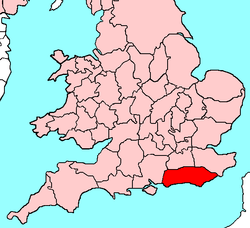
History of Sussex
| Sussex | |
|---|---|
|
| |
 Ancient extent of Sussex | |
| Area | |
| • 1831 | 907,920 acres (3,674 km2)[1] |
| • 1901 | 932,409 acres (3,773 km2)[1] |
| Population | |
| • 1831 | 272,340[1] |
| • 1901 | 602,255[1] |
| Density | |
| • 1831 | 0.3 per acre (74/km2) |
| • 1901 | 0.6 per acre (150/km2) |
| History | |
| • Origin | Kingdom of Sussex |
| • Created | In antiquity |
| • Succeeded by | East Sussex and West Sussex |
| Status | Ceremonial county (until 1974) |
| Chapman code | SSX |
| • HQ | Chichester or Lewes |
| • Motto | We wunt be druv |
Sussex /ˈsʌsᵻks/, from the Old English 'Sūþsēaxe' ('South Saxons'), is a historic county in the south east of England. The foundation of the Kingdom of Sussex is recorded by the Anglo-Saxon Chronicle for the year AD 477, saying that Ælle arrived at a place called Cymenshore in three ships with his three sons and killed or put to flight the local inhabitants.
The foundation story is regarded as somewhat of a myth by most historians, although the archaeology suggests that Saxons did start to settle in the area in the late 5th century.[2][3] The Kingdom of Sussex became the county of Sussex; then after the coming of Christianity; the see originally founded in Selsey, was moved to Chichester in the 11th century. The See of Chichester was coterminous with the county borders.[4] In the 12th century the see was split into two archdeaconries centred at Chichester and Lewes.[5]
Since its creation in the fifth century, Sussex has been subject to periodic reform of its local governance. After the Reform Act of 1832 Sussex was divided into the eastern division and the western division, these divisions were coterminous with the two archdeaconries of Chichester and Lewes.[6] In 1889, following the Local Government Act 1888, using those same boundaries, Sussex was divided into two administrative counties, East Sussex and West Sussex together with three self-governing county boroughs, Brighton, Eastbourne and Hastings. In 1974, under the Local Government Act 1972, the county boundaries were revised with the mid-Sussex area of East Grinstead, Haywards Heath, Burgess Hill and Hassocks being transferred from East Sussex into West Sussex along with Crawley and the Gatwick area that was formerly part of Surrey. The county boroughs were returned to the control of the two county councils but in 1997 the towns of Brighton and Hove were amalgamated as a unitary local authority and in 2000, Brighton and Hove was given City status.[7] Although it is administered as the two ceremonial counties of East and West Sussex, there continue to be a range of organisations that operate throughout the ancient borders of Sussex such as the Diocese of Chichester, Sussex Police, the Sussex Archaeological Society the Sussex History Society and the Sussex Wildlife Trust.
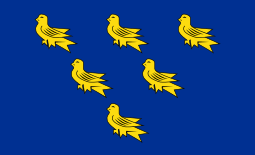
In 2007, Sussex Day was created to celebrate Sussex's rich culture and history. Based on the traditional emblem of Sussex, a blue shield with six gold martlets, the flag of Sussex was recognised by the Flag Institute in 2011. In 2013, Secretary of State for Communities and Local Government Eric Pickles formally recognised and acknowledged the continued existence of England's 39 historic counties, including Sussex.[8][9][10]
Although the name Sussex is derived from the Saxon period between AD 477 to 1066, the history of human habitation in Sussex goes back to the Old Stone (Paleolithic) Age.[11] Sussex has been occupied since those times and although it has been an industrious county it has succumbed to various persecutions, wars, invasions, political unrest and migrations throughout its long history.[11]
Prehistoric Sussex
Stone Age
.jpg)
In 1993 a human-like tibia was found at Boxgrove near Chichester.[12] Then in 1996 further hominid remains were found: two incisor teeth from a single individual recovered from the lower freshwater deposits at the site.[13] The remains came to be known as "Boxgrove man" and are thought to be a species known as Homo heidelbergensis.[13] Boxgrove man apparently lived in a temperate stage immediately prior to the Anglian glaciation, in the Lower Paleolithic period between 524,000 and 478,000 years ago.[12][13]
In 1900 Upper Palaeolithic flintwork was found at a site in the Beedings.[14] Then in 2007–08 Early Upper Palaeolithic archaeology was found at the same site.[14] The archaeology at the Beedings spans a crucial cultural transition in the European Palaeolithic and therefore provides an important new dataset for the analysis of late Neanderthal groups in northern Europe and their replacement by modern human populations.[14]
It is believed that during the Mesolithic Age nomadic hunters arrived in Sussex from Europe.[11][15] At the time (8000 BC), Britain was still connected to the continent, however the ice sheets over northern Europe were melting rapidly and causing the gradual rising of sea levels, which eventually led to the forming of the Straits of Dover, effectively cutting off the Mesolithic people of Sussex from the continent.[11] There have been archaeological finds from these people, mostly in the central wealden area to the north of the Downs. Large amounts of knives, scrapers, arrow heads and other tools have been found.[11]
Close to the River Ouse near Sharpsbridge, a polished axe, polished axe fragments, a chisel and other examples of Neolithic flintwork have been found. The fact that these implements were found close to the River Ouse suggests that some land clearance may have taken place in the river valley during the Neolithic period.[16]
From about 4300 BC to about 3400 BC the mining of flint for use locally and also for wider trade was a major activity in Neolithic Sussex.[17] There was also a Neolithic pottery industry, with styles of pot reminiscent of finds elsewhere, such as Hembury and Grimston/ Lyle Hill.[17][18]
Bronze Age
The transition from the late neolithic to the Early Bronze Age in Sussex is marked by the appearance of Beaker pottery.[19][20] There have been several finds including some in Beaker settlements, a significant settlement was one discovered near Beachy Head, in 1909.[19] The site was partially excavated in 1970 and the finds included pottery, flints, post settings, shallow pits and a midden.[19] The presence of Beaker pottery provides the first evidence of the migration of people from northern Europe since the early Neolithic period.[19] Although some pre-historians now doubt the existence of the Beaker people as migrants and suggest that it was possible that the Beaker culture may have just been a new development of the local neolithic people.[20]
From the Bronze Age (about 1400-1100BC) settlements and burial sites have left their mark throughout Sussex.[21]
Iron Age
There are over fifty Iron Age sites that are known throughout the Sussex Downs. Probably the best known are the hill-forts such as Cissbury Ring.[22] A small number of agricultural settlements, or farmsteads, have been excavated on a large scale.[22] The results of these excavations have provided a picture of the economy, based on mixed farming.[22] Artefacts such as iron ploughshares and sickles were excavated.[22] The presence of animal bones, particularly cattle and sheep, attests to the pastoral element to their economy.[22] Various items have been found that indicate that they used to spin and weave the wool they produced.[22] The Sussex Iron Age dweller supplemented their diet with marine shellfish, the remains of which have been found on several sites.[22]
Towards the end of the Iron Age in 75BC, people from the Atrebates one of the tribes of the Belgae, a mix of Celtic and German stock, started invading and occupying southern Britain.[23][24] This was followed by an invasion by the Roman army under Julius Caesar that temporarily occupied the south-east in 55BC.[24] Then soon after the first Roman invasion had ended, the Celtic Regnenses tribe under, their leader Commius occupied the Manhood Peninsula.[24] Tincomarus and then Cogidubnus followed Commius as rulers of the Regnenses.[24] At the time of the Roman conquest in AD 43 there was an oppidum in the southern part of their territory, probably in the Selsey region.[25]
Roman Sussex

After the Roman invasion Cogidubnus was placed or confirmed by the Romans as ruler of the Regnenses and he took the name Tiberius Claudius Cogidubnus and claimed to be ‘'rex magnus Britanniae'’.[26] His name is mentioned on two exceptionally early Roman inscriptions in his capital of Noviomagus Reginorum (Chichester).[26]
There are a variety of remains in the county from Roman times, coin hoards and decorated pottery have been found.[27]
There are examples of Roman roads such as:
Also a variety of buildings, the best known being:
The coast of Roman Britain had a series of defensive forts on them, and towards the end of the Roman occupation the coast was subject to raids by Saxons.[28] Additional forts were built against the Saxon threat, an example in Sussex being Anderitum (Pevensey Castle).[28] The coastal defences were supervised by the Count of the Saxon Shore.[28] There is some suggestion that around the beginning of the fourth century the Roman authorities recruited mercenaries from the German homelands to defend the southern and eastern coasts of Britain.[29] The area they defended was known as the Saxon Shore.[29] It is possible that these mercenaries remained after the departure of the Roman army and merged with the eventual Anglo-Saxon invaders.[28][29]
Saxon Sussex
Norman Sussex

On Friday, 13 October 1066, Harold Godwinson and his English army arrived at Senlac Hill just outside Hastings, to face William of Normandy and his invading army.[30] On 14 October 1066, during the ensuing battle, Harold was killed and the English defeated.[30] It is likely that all the fighting men of Sussex were at the battle, as the county's thegns were decimated and any that survived had their lands confiscated.[30] The Normans buried their dead in mass graves. There were reports that the bones of some of the English dead were still being found on the hillside some years later. It was believed that it would not be possibe to recover any remaining bones from the battle field area, in modern times, as they would have disappeared due to the acidic soil.[31] However, a skeleton that was found in a medieval cemetery, and originally thought to be associated with the 13th century Battle of Lewes turned out to be contemporary with the Norman invasion.[32] Skeleton 180 had sustained six fatal sword cuts to the back of the skull and was one of five skeletons that had suffered violent trauma. Skeleton 180 was one of 123 remains found in a medieval cemetery belonging to the Hospital of St Nicholas, which was run by monks from Lewes Priory. Many of the excavated skeletons exhibited the tell tale signs of a range of diseases common in that era, including leprosy, but only Skeleton 180 had died from head injuries. The reason why historians had originally thought that skeleton 180 was involved in the battle of Lewes is because the hospital was situated at the epicentre of the conflict. What had puzzled archaeologists though, was that most of the victims of the battle had been buried in mass grave pits dug next to the battle itself; these pits had been discovered by road builders in the 19th century. Analysis now continues on the other remains found, at the site of the hospital, to try and build up a more accurate picture of who the individuals were.[31]
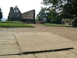
William built Battle Abbey at the site of the battle of Hastings, and the exact spot where Harold fell was marked by the high altar.[30] Norman influence was already strong in Sussex before the Conquest: the abbey of Fécamp had interest in the harbours of Hastings, Rye, Winchelsea and Steyning; while the estate of Bosham was held by a Norman chaplain to Edward the Confessor.[33] After the Norman conquest the 387 manors, that had been in Saxon hands, were replaced by just 16 heads of manors.[33][34]
| The owners of Sussex post 1066[34] | Number of manors | |
|---|---|---|
| 1 | William I | 2 |
| 2 | Lanfranc, Archbishop of Canterbury | 8 |
| 3 | Stigand, Bishop of Selsey* | 9 |
| 4 | Gilbert, Abbot of Westminster | 1 |
| 5 | Abbot of Fécamp | 3 |
| 6 | Osborn, Bishop of Exeter | 4 |
| 7 | Abbot of Winchester | 2 |
| 8 | Gauspert, Abbot of Battle | 2 |
| 9 | Abbot of St Edward's | 1 |
| 10 | Ode** | 1 |
| 11 | Eldred** | 1 |
| 12 | William son of Robert, Count of Eu | 108 |
| 13 | Robert, Count of Mortain | 81 |
| 14 | William de Warenne | 43 |
| 15 | William de Braose | 38 |
| 16 | Roger, Earl of Montgomery | 83 |
| Total | 387 | |
| Notes: * The See was moved from Selsey to Chichester during Stigands tenure. ** Ode and Eldred were Saxon Lords. | ||
The 16 people, in charge of the manors, were known as the Tenentes in capite in other words the chief tenants who held their land directly from the crown.[34][35] The list includes nine ecclesiasticals although the portion of their landholding is quite small and was virtually no different from that under Edward the Confessor.[34] Two of the lords were Englishmen, Ode, who had been a pre-Conquest treasurer, and his brother Eldred.[36] This means that 353 of the 387 manors in Sussex would have been wrested from their Saxon owners and given to Norman Lords by William the Conqueror[34]
The county was of great importance to the Normans; Hastings and Pevensey being on the most direct route for Normandy.[37] Because of this the county was divided into five new baronies, called rapes, each with at least one town and a castle.[33] This enabled the ruling group of Normans to control the manorial revenues and thus the greater part of the county's wealth.[33] William, the Conqueror gave these rapes to five of his most trusted Barons:[37]
- Roger of Montgomery - the combined Rapes of Chichester and Arundel.
- William de Braose - Rape of Bramber.
- William de Warenne - Rape of Lewes
- Robert, Count of Mortain - Rape of Pevensey
- Robert, Count of Eu - Rape of Hastings
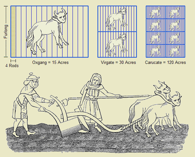
Historically the land holdings of each Saxon lord had been scattered, but now the lords lands were determined by the borders of the rape.[38] The unit of land, known as the hide, in Sussex had eight instead of the usual four virgates,(a virgate being equal to the amount of land two oxen can plough in a season).[38]
The county boundary was long and somewhat indeterminate on the north, owing to the dense forest of Andredsweald.[39] Evidence of this is seen in Domesday Book by the survey of Worth and Lodsworth under Surrey, and also by the fact that as late as 1834 the present parishes of North and South Ambersham in Sussex were part of Hampshire.[40]
Sussex under the Plantagenets
During the Hundred Years War, Sussex found itself on the frontline, convenient both for intended invasions and retaliatory expeditions by licensed French pirates.[41] Hastings, Rye and Winchelsea were all burnt during this period[41] and all three towns became part of the Cinque Ports, a loose federation for supplying ships for the country's security. Also at this time, Amberley and Bodiam castles were built to defend the upper reaches of navigable rivers.[41]
Early modern Sussex
Like the rest of the country, the Church of England's split with Rome during the reign of Henry VIII was felt in Sussex.[42] In 1538 there was a royal order for the demolition of the shrine of Saint Richard, in Chichester Cathedral,[43] with Thomas Cromwell saying that there was "a certain kind of idolatry about the shrine".[43] In the reign of Queen Mary, 41 people in Sussex were burnt at the stake for their Protestant beliefs.[42] Elizabeth re-established the break with Rome when she passed the 1559 Acts of Supremacy and Uniformity. Under Elizabeth I, religious intolerance continued albeit on a lesser scale, with several people being executed for their Catholic beliefs.[41]
Sussex escaped the worst ravages of the English Civil War, although in 1642 there were sieges at Arundel and Chichester, and a skirmish at Haywards Heath when Royalists marching towards Lewes were intercepted by local Parliamentarians. The Royalists were routed with around 200 killed or taken prisoner.[44] Despite its being under Parliamentarian control, Charles II was able to journey through the county after the Battle of Worcester in 1651 to make his escape to France from the port of Shoreham.
Late modern and contemporary Sussex
The Sussex women are very nice in their dress and in their houses. The men and boys wear smock-frocks more than they do in some counties. - William Cobbett. 1822[45]
The Sussex coast was greatly modified by the social movement of sea bathing for health which became fashionable among the wealthy in the second half of the 18th century.[46] Resorts developed all along the coast, including at Brighton, Hastings, Worthing, and Bognor.[46] At the beginning of the 19th century agricultural labourers' conditions took a turn for the worse with an increasing amount of them becoming unemployed, those in work faced their wages being forced down.[47] Conditions became so bad that it was even reported to the House of Lords in 1830 that four harvest labourers (seasonal workers) had been found dead of starvation.[47] The deteriorating conditions of work for the agricultural labourer eventually triggered riots, first in neighbouring Kent, and then in Sussex, where they lasted for several weeks, although the unrest continued until 1832 and became known as the Swing Riots.[47][48]
Railways spread across Sussex in the 19th century and county councils were created for Sussex's eastern and western divisions in 1889.
During World War I, on the eve of the Battle of the Somme on 30 June 1916, the Royal Sussex Regiment took part in the Battle of the Boar's Head at Richebourg-l'Avoué.[49] The day subsequently became known as The Day Sussex Died.[49] Over a period of less than five hours the 17 officers and 349 men were killed, including 12 sets of brothers, including three from one family.[49] A further 1,000 men were wounded or taken prisoner.[49]
With the declaration of the World War II, Sussex found itself part of the country's frontline with its airfields playing a key role in the Battle of Britain and with its towns being some of the most frequently bombed.[50] As the Sussex regiments served overseas, the defence of the county was undertaken by units of the Home Guard with help from the First Canadian Army.[50][51] During the lead up to the D-Day landings, the people of Sussex were witness to the buildup of military personnel and materials, including the assembly of landing crafts and construction of Mulberry harbours off the county's coast.[51]
In the post-war era, the New Towns Act 1946 designated Crawley as the site of a new town.[52] As part of the Local Government Act 1972, the eastern and western divisions of Sussex were made into the ceremonial counties of East and West Sussex in 1974. Boundaries were changed and a large part of the rape of Lewes was transferred from the eastern division into West Sussex, along with Gatwick Airport, which was historically part of the county of Surrey.[53]
Jurisdiction
The system of hundreds had been introduced during the time of the Saxons.[40] In the 7th century Sussex has been estimated to have contained 7,000 families or hides.[54] The creation of the rapes by the Normans introduced boundaries that divided some of the hundreds (and also some of the manors) causing a certain amount of fragmentation.[40] The Arundel Rape covered nearly all of what is now West Sussex until about 1250 when it was split into two rapes, the Arundel Rape and the Chichester Rape.[55] Ultimately Sussex was divided into six rapes; Chichester, Arundel, Bramber, Lewes, Pevensey and Hastings.

At the time of the Domesday Survey, Sussex contained fifty nine hundreds.[56] This eventually increased to sixty-three hundreds and remained unchanged till the 19th century, with thirty eight retaining their original names.[57] The reason why the remainder had their names changed was probably due to the meeting-place of the hundred court being altered. These courts were in private hands in Sussex; either of the Church, or of great barons and local lords.[40]
Independent from the hundreds were the boroughs.
The county court had been held at Lewes and Shoreham until 1086, when it was moved to Chichester. A petition to parliament of 1336 from the 'community of Sussex' asked to have a place assigned for the holding of the county court.[58] After several changes the act of 1504, during the reign of Henry VII, arranged for it to be held alternately at Lewes and Chichester.[59]
In 1107-9 there was construction of a county gaol, in Chichester Castle, however the castle was demolished in around 1217 and another gaol built on the same site.[60] That gaol is known to have been used until 1269, when the site of the prison was given to the Greyfriars to build a priory.[60] In 1242 the counties of Surrey and Sussex were formerly united, and a sharing of prison accommodation resulted almost immediately.[60] Sussex men were imprisoned in Guildford gaol.[60] There were requests for the provision of a county gaol in both Chichester and Lewes at various times to no avail.[60] However the national gaol system became overloaded during the Peasants' Revolt of 1381, and the earl of Arundel was obliged to imprison people in his castles at Arundel and Lewes.[60] Thus Sussex managed to get a county gaol again at Lewes in 1487 and there it remained until it was moved to Horsham in 1541 for a period.[60]
In the middle of the 16th century the assizes were usually held at Horsham or East Grinstead.[61] In the middle of the 17th century a gaol was built in Horsham, then in 1775 a new gaol was built to replace it.[61] In 1788 an additional gaol was built at Petworth, known as the Petworth House of Correction.[61] There were further Houses of Correction built at Lewes and Battle.[62]
It is believed that the last case of someone being executed by being pressed to death (peine forte et dure), in the country, was carried out in 1735 at Horsham.[63] At the assizes a man who pretended to be dumb and lame, was indicted for murder and robbery.[63][64] When he was brought to the bar, he would not speak or plead. Witnesses told the court, that they had heard him speak so he was taken back to Horsham gaol.[64] As he would not plead they laid 100 pounds (45 kg) weight on him, then as he still would not plead, they added 100 pounds (45 kg) more, and a further 100 pounds (45 kg) making a total of 300 pounds (140 kg) weight, still he would not speak; so 50 pounds (23 kg) more was added, when he was nearly dead, the executioner, who weighed about 16 stone (100 kg) or 17 stone (110 kg), laid down upon the board which was over him, and killed him in an instant.[64]
In 1824 there were 109 prisoners in Horsham Gaol, 233 in Petworth House of Correction, 591 in Lewes House of Correction and 91 in Battle House of Correction.[61][65] The last public hanging in Sussex was at Horsham in 1844, a year before the gaol finally closed.[66]
The sheriff's function was to be responsible for the civil justice within the county.[67] Surrey and Sussex shared one sheriff until 1567 when the function was split. Then in 1571 the two counties again shared one sheriff, finally each county was given their own sheriff in 1636.[67] The office of High Sheriff for Sussex then continued until 1974 when it was ended by the local government re-organisation that split Sussex into the two counties of East and West Sussex.[7]
During time of internal unrest or foreign invasions it was usual for the monarch to appoint a lieutenant of the county.[68] The policy of appointing temporary lieutenants continued till the reign of Henry VIII, when Lords Lieutenant were introduced as standing representatives of the crown.[68] The first Lord Lieutenant of the County of Sussex was Sir Richard Sackville in 1550, the Lord Lieutenant was usually also the custos rotulorum of the county and Sackville had been given that the year before.[68][69] The main duties of the Lords Lieutenant was to oversee the military in the county; in Sussex this was the Militia and the Sussex Yeomanry.[68]
As with the Sheriff, the post of Lord Lieutenant of Sussex was ended, in 1974, by the local government re-organisation.[7] There are now separate Sheriffs and Lords Lieutenant for East and West Sussex and the modern day role is largely ceremonial.[70][71]
Private jurisdictions, both ecclesiastical and lay, played a large part in the county. The chief ecclesiastical franchises were those of the Archbishop of Canterbury, the bishop of Chichester and also that of Battle Abbey which was founded by William the Conqueror.[72] The main lay francises were those of the Cinque Ports and the Honour of Pevensey. The Cinque Ports were a group of coastal towns in Kent and Sussex that were given ancient rights and privileges.[73] The main rights were the exemption of taxes and duties and the right to enforce the laws in their jurisdiction.[73] In return for these privileges they were duty bound to provide ships and men in the time of war for the crown.[73] Traditionally when a collection of lands owned by the Crown is held in tenancy then the tenant is known as the tenant-in-chief and the lands held in such a way was called an honour.[74] The Honour of Pevensey was a collection of estates in Sussex.[73] The Honour of Pevensey was also known as the Lordship of Pevensey Castle or the Honour of The Eagle after the lords of L'Aigle who invariably were the tenant-in-chief.[75] The name L'Aigle (French for eagle) supposedly being derived from a town in Normandy, named after an eagle, that had built its nest in the area.[75]
Borough English in Sussex
Borough-English was the custom that lands should descend to the youngest son or daughter, or, in default of issue, to the youngest brother of the deceased.[76] The name originated from a case in Nottingham in 1327 when the English borough, or part of the town, held to ultimogeniture, the French (Norman) part to primogeniture.[77] In Sussex, inheritance by Borough-English, could still be found on 134 manors after 1750.[78]
Gavelkind was the practice of partible or equal inheritance, as opposed to primogeniture. It was predominant in Kent but was also found, across the county border, in Sussex.[79] It existed in Rye, in the large manor of Brede, and in Coustard manor (in Brede parish).[80][81]
Borough-English and gavelkind were finally abolished in England and Wales by the Administration of Estates Act 1925[82]
Religion
Several polytheistic religions were practised in Sussex before Christianity was firmly established in Sussex in 7th century, including Celtic polytheism and Roman religion. Christianity was practised during part of the Romano-British period, but was replaced in the 5th century by the polytheistic religion of the South Saxons. According to Bede, it was the last area of what was to become England to be converted.[83][84] After the Council of London of 1075 decreed that sees should be centred in cities rather than vills,[85] the South Saxon diocese, with its see at Selsey was transferred to Chichester.
Like the rest of the country the Church of England's split with Rome during the reign of Henry VIII, was felt in Sussex.[42] There had been twenty years of religious reform, when the Catholic, Mary Tudor succeeded to the throne of England in 1553.[86] Marys persecution of Protestants earned her the nickname Bloody Mary.[86] The national figure for those Protestants burnt at the stake, during her reign, was around 288 and included 41 in Sussex.[42] Most of the executions in Sussex were at Lewes. In 1851 the authorities organised a census of places of worship in England and Wales.[87] The figures for Sussex indicated that there were more Anglican than non-conformist places of worship.[87] In the neighbouring counties of Hampshire and Kent, there were more non-conformist places than Anglican.[87]
Parliamentary history

The Parliamentary history of the county began in the 13th century. In 1290, the first year for which a return of knights of the shire is available, Henry Hussey and William de Etchingham were elected.[6]
In 1801 the Members of Parliament(MPs) for the counties on the south coast of England were elected to a third of all the seats in parliament, although they represented only about 15% of the nation's population.[88] The way that the country's electoral system worked had changed little since the first parliament in 1295.[88] The counties each returned two MPs and each borough designated by Royal charter also returned two MPs.[88] This produced the situation where some of the towns of the north that had grown large during the industrial revolution had no representation whereas smaller towns in the south, that had been important in medieval times, were still able to have two MPs.[88]
Although there had been various proposals to reform the system from 1770, it was not till 1830 when a series of factors saw the Reform Act 1832 introduced.[88] The larger industrial towns of the north were enfranchised for the first time and smaller English boroughs (known as Rotten Boroughs) were disenfranchised, including Bramber, East Grinstead, Seaford, Steyning and Winchelsea in Sussex.[88] The Representation of the People Act 1884 and the Redistribution of Seats Act 1885 (together known as the Third Reform Act) were responsible for redistributing 160 seats and extending suffrage.[88]
After the Reform Act of 1832 Sussex was divided into the eastern division and the western division and two representatives were elected for each division.[6] In June 1832 the Honorable C.C. Cavendish and H.B. Curteis Esquire were elected in the eastern division and the Earl of Surrey and Lord John George Lennox were elected for the western division.[6] There was a total of 3478 votes cast in the eastern division and 2365 votes in the western division.[6]
Before the 1832 reform two members each had been returned by Arundel, Chichester, Hastings, Horsham, Lewes, Midhurst, New Shoreham (with the rape of Bramber) and Rye. Arundel, Horsham, Midhurst and Rye were each deprived of a member in 1832, Chichester and Lewes in 1867, and Hastings in 1885. Arundel was disfranchised in 1868, and Chichester, Horsham, Midhurst, New Shoreham and Rye in 1885.[88] Under the new system the constituencies were based on unit numbers rather than historic towns.[88] The reforms of the 19th century made the electoral system more representative, but it was not till 1928 there was universal suffrage.[88]
Rebellions, riots and unrest

Sussex, from its position, was constantly the scene of preparations for invasion, and was often concerned in rebellions.[89]
In 1264 there was a civil war in England between the forces of a group of barons led by Simon de Montfort, against the royalist forces led by Prince Edward, in the name of Henry III, known as the Second Barons' War. On 12 May 1264, Simon de Montfort's forces occupied a hill known as 'Offam Hill' outside Lewes. Royalist forces tried to storm the hill but ultimately were defeated by the barons'.[90] The actual site of what became known as the Battle of Lewes is somewhere between the town and the hill, the battle was bitterly fought for over five hours.[90][91][92] During the 19th century, Victorian road builders constructing the Brighton-Lewes turnpike in the area of the battle discovered mass graves with around 2000 bodies in them.[91]
During the Middle Ages the Wealden peasants rose up in revolt on two ocaasions, the Peasants' Revolt in 1381 under Watt Tyler, and in Jack Cade's rebellion of 1450.[93] Cade's rebellion was not just supported by the peasant class, many gentlemen, craftspeople and artisans also the Abbot of Battle and Prior of Lewes flocked to his standard in revolt against the corrupt government of Henry VI.[93] Jack Cade was fatally wounded in a skirmish at Heathfield in 1450.[93]
At the time of the English Civil War the counties sympathies were divided, Arundel supported the king, Chichester, Lewes and the Cinque Ports were for parliament.[94] Most of the west of the county were for the king and included a powerful group with the bishop of Chichester and Sir Edward Ford, sheriff of Sussex, in their number.[94] Exceptionally, Chichester was for parliament largely due to an influential brewer named William Cawley.[94][95] However the group of royalists led by Edward Ford managed to get a force together to capture Chichester, in 1642, for the king and imprisoned 200 parliamentarians.[94][95]
The roundhead army under Sir William Waller besieged Arundel and after its fall marched on Chichester and restored it to parliament.[96] A military governor, Algernon Sidney was appointed in 1645.[95] Chichester was then demilitarised, in 1647–1648 and remained in parliaments hands for the rest of the civil war.[95] The brewer William Cawley became a MP for Chichester in 1647 and was one of the signatories on King Charles I death warrant.[97]
At the beginning of the 19th century agricultural labourers conditions took a turn for the worse with an increasing amount of them becoming unemployed, those in work faced their wages being forced down.[47] Conditions became so bad that it was even reported to the House of Lords in 1830 that four harvest labourers (seasonal workers) had been found dead of starvation.[47] The deteriorating conditions of work for the agricultural labourer eventually triggered off riots in Kent during the summer of 1830.[47] Similar action spread across the county border to Sussex where the riots lasted for several weeks, although the unrest continued until 1832 and were known as the Swing Riots.[47][48]
The Swing riots were accompanied by action against local farmers and land owners. Typically, what would happen is a threatening letter would be sent to a local farmer or leader demanding that automated equipment such as threshing machines should be withdrawn from service, wages should be increased and there would be a threat of consequences if this did not happen, the letter would be signed by a mythical Captain Swing. This would be followed up by the destruction of farm equipment and occasionally arson.[47][48]
Eventually the army was mobilised to contain the situation in the eastern part of the county, whereas in the west the Duke of Richmond took action against the protesters by the use of the yeomanry and special constables.[98] The Sussex Yeomanry were subsequently disparagingly nicknamed the workhouse guards.[99] The protesters faced charges of arson, robbery, riot, machine breaking and assault.[98] Those convicted faced imprisonment, transportation or ultimately execution.[98] The grievances continued encouraging a wider demand for political reform, culminating in the introduction of the Reform Act 1832.[98]
One of the main grievances of the Swing protesters had been what they saw as inadequate Poor Law benefits, Sussex had the highest poor-relief costs during the agricultural depression of 1815 to the 1830s and its workhouses were full.[100] The general unrest, particularly about the state of the workhouses, was instrumental in the introduction of the Poor Law Amendment Act 1834.[100]
Wars
During the French revolutionary and Napoleonic wars (1793–1815), a European coalition was formed, that included Britain, with the intention of crushing the newly founded French Republic, so defensive measures were taken in Sussex.[101]
In 1793 at Brighton two batteries were built on the towns east and west cliffs (replacing older installations).[101] The Sussex Yeomanry was founded in 1794, and numbers of gentlemen and yeomanry volunteered to join the part-time cavalry regiment to serve in case of invasion by Bonaparte.[102] Between 1805 and 1808 a series of defensive towers known as Martello towers were erected along the Sussex and Kent coasts, and later on the east coast.[101] The Admiralty commissioned a visual signalling system to allow communications between ships and the shore and from there to the Admiralty in London; Sussex had a total of 16 signalling stations on its coast.[101] A central fort and supply base for the towers, the Eastbourne Redoubt at Eastbourne was constructed between 1804-1810.[101] It is now home to the Royal Sussex Regiment Museum. In the 1860s, possible wars with France prompted more defence building, including the fort at Newhaven.[101]
At the outbreak of the First World War in August 1914, the landowners of the county employed their local leadership roles to recruit volunteers for the nations forces.[103] The owner of Herstmonceux Castle, a Claude Lowther, recruited enough men for three Southdown Battalians who were known as Lowthers Lambs.[104] The Royal Sussex Regiment fielded a total of 23 battalions in the Great War.[105] After the war, St Georges Chapel, in Chichester Cathedral, was restored and furnished as a memorial to the fallen of the Royal Sussex Regiment.[106] Nearly 7,000 of the regiment lost their lives, in the First World War, and their names are recorded on the panels that are attached to the walls of the chapel.[106]
On the Sussex boys are stirring
In the wood-land and the Downs
We are moving in the hamlet
We are rising in the town;
For the call is King and Country
Since the foe has asked for war,
And when danger calls, or duty
We are always to the fore.
From Lowthers Lambs marching song.[105]
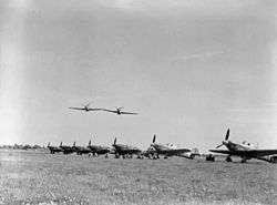
With the declaration of the Second World War, on 3 September 1939, Sussex found itself part of the country's frontline with its airfields playing a key role in the Battle of Britain and with its towns being some of the most frequently bombed.[50] The first line of defence was the coastal crust consisting of pillboxes, machine-gun posts, trenches, rifle posts, anti-tank obstacles plus scaffolding, mines and barbed wire.[50] As the Sussex regiments were serving overseas for large parts of the war, the defence of the county was undertaken by units of the Home Guard with help between 1941 and early 1944 from the First Canadian Army.[50][51]
During the war every part of Sussex was affected.[50] Army camps of both the tented and also the more permanent variety sprang up everywhere.[50] Sussex played host to many servicemen and women, including the 2nd Canadian Infantry Division, the 4th Armoured Brigade, the 30th US Division, the 27th Armoured Brigade and the 15th Scottish Division.[51] Besides airmen and women from the British Commonwealth, fighter squadrons from the Free Belgian, Free French, Free Czechs, Free Polish were regularly based at airfields around Sussex.[51]
During the lead up to the D-Day landings, the people of Sussex were witness to the buildup of military personnel and materials, including the assembly of landing crafts and construction of Mulberry harbours off the county's coast.[51] Five new airfields were built to provide additional support for the D-Day landings, four near Chichester and one near Billingshurst.[51]
A legacy of the D-Day landings are the sections of Mulberry harbour that lay broken and abandoned on the sea floor 2 miles (3.2 km) off the coast, of Selsey Bill, having missed the invasion.[107]
Industries in Sussex
Sussex was an industrial county, from the stone age, with the early production of flint implements till when the use of coal and steam power moved industry nearer the coalfields, of the north and midlands.[14][108] The county also has been known for its agriculture.
Agriculture
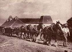
Sussex has retained much of its rural nature: apart from the coastal strip, it has few large towns. Although in 1841 over 40% of the population were employed in agriculture (including fishing), today less than 2% are so employed. The wide range of soil types in the county leads to great variations in the patterns of farming. The Wealden parts are mostly wet sticky clays or drought-prone acid sands and often broken up into to small irregular fields and woods by the topography, making it unsuitable for intensive arable farming. Pastoral or mixed farming has always been the pattern here, with field boundaries often little changed since the medieval period. Sussex cattle are the descendants of the draught oxen, which continued to be used in the Weald longer than in other parts of England. Agriculturalist Arthur Young commented in the early 18th century that the cattle of the Weald "must be unquestionably ranked among the best of the kingdom."[109] William Cobbett, riding through Ashdown Forest, said he had seen some of the finest cattle in the country on some of the poorest farms.[110] Areas of cereals grown on the Weald have risen and declined with the price of grain. The chalk downlands were traditionally grazed by large numbers of small Southdown sheep, suited to the low fertility of the pasture, until the coming of artificial fertiliser made cereal growing worthwhile. Yields are still limited by the alkalinity of the soil. Apart from a few areas of alluvial loam soil in the river valleys, the best and most intensively farmed soils are on the coastal plain, where large-scale vegetable growing is commonplace. Glasshouse production is also concentrated along the coast where hours of sunshine are greater than inland.
There are still fishing fleets, notably at Rye and Hastings, but the number of boats is much reduced. Historically, the fisheries were of great importance, including cod, herring, mackerel, sprats, plaice, sole, turbot, shrimps, crabs, lobsters, oysters, mussels, cockles, whelks and periwinkles. Bede records that St Wilfrid, when he visited the county in 681, taught the people the art of net-fishing. At the time of the Domesday survey, the fisheries were extensive and no fewer than 285 salinae (saltworks) existed. The customs of the Brighton fishermen were documented in 1579.
There are working harbours at Rye, Hastings, Newhaven and Shoreham; whilst Pagham and Chichester harbours cater for leisure craft, as does Brighton Marina.
Iron working
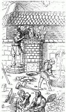
Iron Age wrought iron was produced by means of a bloomery followed by reheating and hammering.[111] With the type that was common in Sussex a round shallow hearth was dug out, clay hard-packed to line it, then layers of hammered ore and charcoal were put down and the whole lot covered by a clay beehive structure, with holes at the side for the insertion of foot or hand bellows.[112] The material inside the beehive furnace was then ignited and it took two to three days for the process to complete, leaving semi-molten lumps of iron, known as blooms on the hearth.[112][113] The output from these types of furnace, was very small as everything had to cool down before the iron could be retrieved.[112] The iron so retrieved could then be worked by using the heat and beat technique to form wrought iron implements such as weapons or tools.[114] Around a dozen pre-Roman sites have been found in eastern Sussex, the westernmost being at Crawley.[115]
The Romans made full use of this resource, continuing and intensifying native methods, and iron slag was widely used as paving material on the Roman roads of the area.[116] The Roman iron industry was mainly in East Sussex with the largest sites in the Hastings area. The industry is thought to have been organised by the Classis Britannica, the Roman navy.[117]
Little evidence has been found of iron production after the Romans left until the ninth century when a primitive bloomery, of a continental style, was built at Millbrook on Ashdown Forest, with a small hearth for reheating the blooms nearby.[118] Production based on bloomeries then continued till the end of the 15th century when a new technique was imported from northern France that allowed the production of cast iron.[112] A permanent blast furnace was constructed; into the furnace chamber was inserted a pipe fed by bellows that could be operated by a wheel; the wheel was rotated by the use of water power, oxen or horses.[114] Pairs of bellows continuously forced air into the furnace chamber, producing higher temperatures such that the iron completely melted and could be run off from the base of the chamber and into moulds. This allowed a continuous process that usually ran during the winter and spring seasons, ceasing when water supplies to drive the bellows dwindled in the summer.[118]
"Full of iron mines it is in sundry places, where for the making and fining whereof there bee furnaces on every side, and a huge deale of wood is yearely spent..."
From William Camden's description of 17th century Sussex.[119]
Henry VIII, urgently needed cannon for his new coastal forts, but casting these in the traditional bronze would have been very expensive.[120] Previously iron cannons had been made by building up bands of iron bound together with iron hoops; such cannons had been used at Bannockburn in 1314.[114] There had also been some cast cannons made in the Weald but with separate barrels and breeches.[120]
In Buxted the local vicar, the Reverend William Levett, was also a gun-founder, he recruited a Ralf Hogge to help him produce cannon and in 1543 his employee cast an iron muzzle-loading cannon.[121] It was cast in one piece, using a pattern based on the latest bronze ordnance.[120] The navy, complained that the new guns were too heavy but bronze was ten times more costly, so in fortifications and for arming merchant ships iron guns were preferred.[120] Gradually, owing to their toughness and validiti, an important export trade in wealden guns built up and they remained dominant internationally until displaced by Swedish guns around 1620.[120] Both men made a lot of money out of the trade, and Hogge built a house on the road to Levetts church. Hogge put a rebus, on his house, with a hog on it as a pun for his name.[121]
The large supply of wood in the county made it a favourable centre for the industry, all smelting being done with charcoal till the middle of the 18th century.[121]
Glass making
The glass making industry started on the Sussex/ Surrey border in the early 13th century and flourished till the 17th century.[122] The industry, in Sussex, during the 16th century spread to Wisborough Green then to Alfold, Ewhurst, Billinghurst and Lurgashall.[122] Many of the artisans in the industry were immigrants from France and Germany.[122] The manufacturing process used timber for fuel, sand and potash(which served as flux).[123]
Glass production in the English midlands using coal for the smelting process, plus opposition to the use of timber in Sussex, led to the collapse of the Sussex glass making industry in 1612.[122]
Forestry
When the Romans arrived in Sussex around AD 43, they would have found remote bands of people smelting iron in the forest of Andresweald.[124] Timber being used to produce charcoal to fuel the smelting process.[112] There is evidence that the Roman engineers improved the road system in the area, by first metalling the old cart tracks and then putting in new roads.[124] This was so they could produce and distribute the wrought iron more efficiently.[124]
The Anglo-Saxon Chronicle, commissioned in the 9th century by Alfred the Great, provides a description of the forest that covered the Sussex Weald. It says that the forest was 120 miles (190 km) wide and 30 miles (48 km) deep (although probably closer to 90 miles (140 km) wide).[125][126] The forest was so dense that even the Domesday Book did not record some of its settlements.[126]
The Weald was not the only area of Sussex that was forested in Saxon times, for example at the western end of Sussex is the Manhood Peninsula, which these days is largely deforested, however the name is probably derived from the Old English maene-wudu meaning "men's wood" or "common wood" indicating that it was once woodland.[127]
During and before the reign of Henry VIII, England imported a lot of the wood for its naval ships from the Hanseatic league.[128] Henry wanted to source the materials for his army and navy domestically.[128] So it was largely the forests of Sussex that met this demand for wood, Sussex oak being considered the finest shipbuilding timber.[128] Vast amounts of wood were consumed to build ships and produce charcoal for the foundry furnaces.[128] Faced with diminishing stocks of wood due to the large consumption from the ship, iron and glass making industries, parliament introduced bills to manage the stocks more efficiently however the parliamentary bills were never past, with the result that the countys forests were decimated.[128] The poet Michael Drayton in his poem Poly-Olbion, published in the early 17th century, made the trees denounce the iron trade:
Jove's oak, the war-like ash, veined elm, the softer beech
Short hazel, maple plain, light asp and bending wych
Tough holly and smooth birch, must altogether burn.
What should the builder serve, the forger's turn
When under publick good, base private gain takes hold.
And we, poor woeful woods, to ruin lastly sold.
From Michael Drayton's Poly-Olbion[129]
Despite parliamentary efforts the forests of Sussex continued to be consumed. However, in 1760 Abraham Darby discovered how to replace charcoal with coke in his blast furnaces, which resulted in production being moved nearer the coal mines.[130] By that time the forests had been completely devastated and the roads ruined by the transport of ore and pig iron.[130] The High Weald still has about 35,905 hectares (138.63 sq mi) of woodland, including areas of ancient woodland equivalent to about 7% of the stock for all England.[131] When the Anglo Saxon Chronicle was compiled in the 9th century there was thought to be about 2,700 square miles (700,000 ha) of forest in the Sussex Weald.[125][126]
Wool
In 1340-1341 there was about 110,000 sheep in Sussex.[132] Edward III commanded that his Chancellor should sit on the woolsack in council as a symbol of the pre-eminence of the wool trade at the time.[133] In 1341 the greatest wool production in Sussex was in the eastern part of the county, and in the west of the county, the port of Chichester was extended along the whole coast from Southampton to Seaford for the collection of customs on wool.[134][135] Also Chichester, despite its geographical disadvantages ranked as the seventh port in the kingdom and was one of the wool ports named in the Statute of the Staple of 1353.[135]
In the early 15th century most production of wool was within 15 miles (24 km) of Lewes.[134] In the 16th century weavers were to be found in nearly every parish as were fullers and dyers.[136] Chichester was an early centre of the weaving of cloth and also for the spinning of linen.[136]
In 1566 an act that prohibited the export of "unwrought or unfinished cloths" led to the demise of the industry in Sussex, and by the beginning of the 18th century it had virtually collapsed; Daniel Defoe commented, in 1724, that the "..whole counties of Kent, Sussex, Surrey and Hampshire, are not employ'd in any considerable Woolen Manufacture;".[137][138]
Clay working (pottery, tiles, bricks)
As much of the Mid Sussex area has clay not far under the surface, clay has in the past been a focus of industry in central Sussex, in particular in the Burgess Hill area. In the first quarter of the 20th century, Burgess Hill and the Hassocks and Hurstpierpoint areas had many kilns, clay pits and similar infrastructure to support the clay industry: nowadays the majority of this form of industry has left the area, although it still can be seen in place names such as "Meeds Road", "The Kiln", or Oakmeeds Community College, which is named after the oak trees in the area and Meeds Pottery, a once significant pottery in the centre of Burgess Hill. At the height of the success of this industry, tiles and bricks from Sussex were used to build landmarks such as Manchester's G-Mex. In 2007 the local district council produced plans to close the only remaining tile works in the area and use the site for residential development. Then in 2015 the last tile works moved to a new home in Surrey.[139][140]
Communications
Roads
After the Romans left, roads in the country fell into disrepair and in Sussex the damage was compounded by the transport of material for the iron industry.[130] A government report describing the condition of a road between Surrey and Sussex in the 17th century as "very ruinous and almost impassable." [141] In 1749 Horace Walpole wrote to a friend complaining that if he desired good roads "never to go into Sussex" and another writer said that the "Sussex road is an almost insuperable evil".[142] Because of the state of the county's roads the major transport network for Sussex had been by way of sea and river, but this had become increasingly unreliable as well.[143]
Roads had been maintained by the parishes, in a system established in 1555, a system that had proved increasingly ineffective given the relentless increase in traffic.[143] Consequently, in 1696, during the reign of William III, the first Turnpike Act was passed and was for the repair of the highway between Reigate in Surrey and Crawley in Sussex.[141] The act made provision to erect turnpikes, and appoint toll collectors; also to appoint surveyors, who were authorized by order of the Justices to borrow money at 5 per cent, on security of the tolls.[141]
Other turnpike acts followed with the roads being built and maintained by local trusts and parishes. The majority of the roads were maintained by a toll levied on each passenger (who usually would have been transported by stage coach), a few roads were still maintained by the parishes with no toll levied.[65] There were 152 Acts of Parliament by the mid-19th century, for the formation, renewel and amendment of the turnpikes in the county.[144] A report on the county's turnpike trusts, published in 1857, said that there were fifty-one trusts covering 640 miles (1,030 km) of road, with 238 toll gates or bars, giving an average of one toll gate every 2.5 miles (4.0 km).[145][146]
The last turnpike to be constructed in the county was between Cripps Corner and Hawkhurst in 1841.[146][147] The system of turnpikes, coaches and coaching inns collapsed in the face of competition from the railways.[147] By 1870 most of the county's Turnpike Trusts were wound up putting hundreds of coachmen and coachbuilders out of business.[147] The conditions of the county's roads then deteriorated until the creation of the new county council in 1889, who assumed responsibility for the maintenance of the county's roads.[148]
At the beginning of the 20th century, nearly all the first class roads had been turnpikes in 1850.[148] During the course of the 20th century, the car and the lorry challenged the supremacy of the railways.[148]
The two counties of East and West Sussex only have a total of 12 kilometres (7.5 mi) of motorway and relatively small amounts of dual carriageway.[149] Two of the "A" roads that traverse Sussex from east to west are the A27 and the A259, a combination of these two roads provide the major route across Sussex, the route is only dual-carriageway for part of its length; both roads run parallel to the Sussex coast.[149]
The main north south road, that connects the coast to the London orbital M25, is the M23/ A23.[148] According to the Highways Agency the removal of most of the east/ west bottlenecks, for example improvements to the Chichester by-pass, will not occur for some time to come; although in their 2013 spending review the British government recognised this and said that they will fund a feasibility study that will include looking at these congestion issues.[150][151][152]
Canals and navigations
The first canals that were constructed in Sussex, can be described as navigations, in that their purpose was to make the lower reaches of the county's rivers navigable.[153] The rivers had suffered from centuries of neglect, which had made navigation, even for small craft, difficult.[153]
Examples of navigations in Sussex are:
Eventually, true canals were also built, examples being:
When the railways arrived, in Sussex, they provided an alternative to the canals and waterways, the canal companies revenue quickly dropped resulting in most of them closing for business by the beginning of World War I.[148]
Railways
In 1804 Richard Trevithick, a Cornish engineer, built the first steam locomotive for a railway.[154] His seven-tonne locomotive hauled 10 tonnes of iron and 70 passengers on a 9 miles (14 km) journey from the Penydarren Ironworks near Merthyr Tydfil to the Glamorganshire Canal at Abercynon, reaching a top speed of almost 5 miles per hour (8.0 km/h).[155]
George Stephenson built the engine Locomotion for the Stockton and Darlington railway, which was opened in 1825 for both passenger and goods traffic; Locomotion pulled thirty-six wagons containing coal, grain and 500 passengers a distance of 9 miles (14 km) at a top speed of 15 miles per hour (24 km/h).[156]
The Manchester to Liverpool railway of 1830 was the first to convey passengers and goods entirely by mechanical traction. Stephenson's Rocket, which won the famous Rainhill trials in 1829, was the first steam locomotive designed to pull passenger traffic quickly.[154]
Brightons proximity to London made it an ideal place to provide short holidays for Londoners.[157] In the 1830s, during the summer, the London Brighton road would see around 40 coaches a day plus a number of private carriages taking visitors to the coast.[157] The road was in a poor condition so proposals to build a railway was suggested as early as 1806.[157] However, it was not till 1823 that a serious scheme was mooted.[157] There followed years of discussion and argument with various groups proposing different routes, then finally in 1837 the London and Brighton Railway Bill with branches to Shoreham and Newhaven received Royal assent.[157] In 1838 the directors of the London and Brighton Railway Company (L&BR) stated that the railroad would be different from the rest of the country in that it would be a passenger only railway.[157]
In the 18th century Brighton had been a town in terminal decline until two things happened:
- In 1750 a Dr Richard Russell recommended Brighton for a seawater cure.[158]
- From 1783 the Prince of Wales started visiting Brighton on a regular basis making it a fashionable destination.[158]
These two events increased the amount of visitors to the town, however in 1841 when the L&BR opened for business, of Brighton's 8,137 stock of houses, some 1,095 stood empty.[159] But within 40 years of the railways arrival Brighton's resident population had doubled.[159]
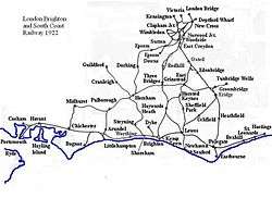
After the opening of the Brighton line, within a few years branches were made to Chichester on the west and Hastings and Eastbourne to the east.[160] In 1846 the L&BR merged with the London and Croydon Railway (L&CR), the Brighton and Chichester Railway and the Brighton, Lewes and Hastings Railway to form the London, Brighton and South Coast Railway(LB&SCR).[161] The LB&SCR continued as an independent entity until the Railways Act 1921, which saw the merger of various rail companies, in the south and south east, into the Southern Railway Company(SR); formed on 1 January 1923.[162][163] Two railway companies in the county, that were not absorbed by the SR, was Volk's Electric Railway the world's first electric railway, that runs along the front at Brighton and opened in 1883, and the West Sussex Railway, a light railway between Chichester and Selsey, opened in 1897 (and closed in 1935).[164][165]
SR was the smallest of four groups that were brought together by the Railways Act 1921.[166] The LB&SCR had partly electrified their network before World War I, however that had been an overhead system, SR decided to electrify their network using the third rail DC system.[166] During World War II the SR was heavily involved with transporting armed services traffic and was bombed on many occasions.[166] After the war SR was nationalised in 1948, and became the Southern Region of British Railways.[166]
Following John Major's victory in the 1992 General Election, the conservative government published a white paper, indicating their intention to privatise the railways.[166][167]
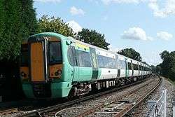
The government went ahead with their plans and franchises were awarded to train operating companies (TOC).[166] The main TOC in Sussex, from September 2014, is the "Thameslink, Southern and Great Northern" franchise operated by Govia. This consists of the Southern Railway who operate southcoast and services to Victoria and London Bridge; Thameslink for services from Brighton to Bedford via London and the London and South Eastern Railway for services between eastern Sussex and London.[168]
Ports
The two major ports in Sussex are at Newhaven, opened in 1579, and at Shoreham opened in 1760.[169] Other ports such as Pevensey, Winchelsea, and Rye now lie stranded from the current coastline.[170] Other harbours that existed such as Fishbourne, Steyning, Old Shoreham, Meeching and Bulverhythe are long since silted up and have been built over.[170]
See also
- Sussex Day - Celebrated each year on 16 June
- History of local government in Sussex
- History of England
- History of Brighton
- History of Worthing
- Weald and Downland Open Air Museum - containing about 50 historic buildings dating from the 13th to 19th century.
Notes
- 1 2 3 4 National Statistics - 200 Years of the Census in Sussex
- ↑ ASC Parker MS. AD 477.
- ↑ Welch. Anglo-Saxon England p. 9.
- ↑ Diocese of Chichester Website
- ↑ Diane Greenway. The Medieval Cathedral in Hobbs. Chichester Cathedral. pp. 14–15
- 1 2 3 4 5 Horsfield. The History, Antiquities and Topography of the County of Sussex. Volume II. Appendix pp. 23-75.
- 1 2 3 John Godfrey. Local Government in the 19th and 20th Century in An Historical Atlas of Sussex. pp. 126–127.
- ↑ "Eric Pickles: celebrate St George and England's traditional counties". Department for Communities and Local Government. 23 April 2013. Retrieved 22 June 2013.
- ↑ Kelner, Simon (23 April 2013). "Eric Pickles's championing of traditional English counties is something we can all get behind". The Independent. London. Retrieved 22 June 2013.
- ↑ Garber, Michael (23 April 2013). "Government 'formally acknowledges' the Historic Counties to Celebrate St George's Day". Association of British Counties. Retrieved 22 June 2013.
- 1 2 3 4 5 Armstrong. A History of Sussex. Chapter 2. The first Inhabitants
- 1 2 C B Stringer and E Trinkham. The Human Tibia from Boxgrove. Chapter 6.2 in Boxgrove: A Middle Pleistocene Hominid Site at Eartham Quarry, Boxgrove, West Sussex
- 1 2 3 Roberts. Boxgrove: A Middle Pleistocene Hominid Site at Eartham Quarry, Boxgrove, West Sussex (English Heritage Archaeological Report). Summary. p.xix
- 1 2 3 4 Pope. Early Upper Palaeolithic archaeology at Beedings. Archaeology International Issue 11: p. 33
- ↑ Peter Drewett. Late Hunters and Gathers in Leslie. An Historical Atlas of Sussex. pp. 14–15
- ↑ Butler. Mesolithic and later flintwork from Moon’s Farm, Piltdown, East Sussex, SAC. pp. 222–24.
- 1 2 Drewett. Neolithic Sussex: published in 'Archaeology in Sussex to AD 1500 : Essays for Eric Holden.' p. 27.
- ↑ Alison Haggarty . Machrie Moor, Arran: recent excavations at two stone circles. pp. 59–60
- 1 2 3 4 Ellison. The Bronze Age of Sussex. Essay published in 'Archaeology of Sussex to AD 1500: Essays for Eric Holden.' p. 30.
- 1 2 Hutton. The Pagan Religions of the Ancient British Isles. pp. 88–89. The author discusses the possibility that the Beaker people may not have existed.
- ↑ Ann Ellison. The Bronze Age of Sussex. Essay in Archaeology of Sussex to AD 1500: Essays for Eric Holden. fig.14. - distribution of Bronze Age sites in Sussex.
- 1 2 3 4 5 6 7 Bedwin. Iron Age Sussex-Downs and Coastal Plain: published in 'Archaeology in Sussex to AD 1500 : Essays for Eric Holden'. p. 41.
- ↑ Koch. Celtic culture. Retrieved 29 October 2011 pp. 195-196
- 1 2 3 4 Armstrong. A History of Sussex. Ch. 3.
- ↑ Cunliffe. Iron Age communities in Britain. p. 169.
- 1 2 Cannon. A Dictionary of British History.
- ↑ White. Mid-Fifth Century Hoard. pp. 301–315
- 1 2 3 4 Myers. The English Settlements. pp. 83-89.
- 1 2 3 Jones. The end of Roman Britain. pp. 32–37.
- 1 2 3 4 Seward. Sussex. pp. 5–7.
- 1 2 Edwina Livesay. Skeleton 180 Shock Dating Result in Sussex Past and Present Number 133. p. 6
- ↑ For detail on the excavation see Luke Barber and Lucy Siburn. The medieval hospital of St Nicholas, Lewes, East Sussex in SAC Vol. 148. pp. 79-109
- 1 2 3 4 Mark Gardiner and Heather Warne. Domesday Settlement in Kim Leslie's. An Historical Atlas. pp. 34–35
- 1 2 3 4 5 Horsfield. The History of the county of Sussex. Volume I. pp. 77–78
- ↑ Friar. The Sutton Companion to Local History. p. 429
- ↑ Dennis Haselgrove. The Domesday Record of Sussex in Brandon's South Saxons. p. 193
- 1 2 Armstrong. A History of Sussex. pp. 48–58
- 1 2 Brandon. The South Saxons. Chapter IX. The Domesday Record of Sussex
- ↑ Brandon. The South Saxons. Ch. VI. The South Saxon Andredesweald.
- 1 2 3 4 Carol Adams. Medieval Administration in Kim Leslie's. An Historical atlas of Sussex. pp. 40–41.
- 1 2 3 4 Lowerson, John (1980). A Short History of Sussex. Folkestone: Dawson Publishing. ISBN 978-0-7129-0948-8.
- 1 2 3 4 Peter Wilkinson. The Struggle for Protestant Reformation 1553-1564: in Kim Leslie's. An Historical Atlas of Sussex. pp. 52-53
- 1 2 Stephens Memorials of the See of Chichester. pp. 213-214
- ↑ "1642: Civil War in the South East". Retrieved 2011-11-29.
- ↑ Cobbett. Rural Rides. p. 55
- 1 2 Brandon, Peter (2009). The Shaping of the Sussex Landscape. Snake River Press.
- 1 2 3 4 5 6 7 8 Harrison. The common people. pp. 249-253
- 1 2 3 Horspool. The English Rebel. pp. 339 -340
- 1 2 3 4 "The Day Sussex Died". Retrieved 29 November 2011.
- 1 2 3 4 5 6 7 Kim Leslie and Marlin Mace. Sussex Defences in the Second World War in Kim Leslie. An Historical Atlas of Sussex. pp. 118-119.
- 1 2 3 4 5 6 7 Brandon. Sussex. pp. 302-309.
- ↑ "Select Committee on Transport, Local Government and the Regions: Appendices to the Minutes of Evidence. Supplementary memorandum by Crawley Borough Council (NT 15(a))". United Kingdom Parliament Publications and Records website. The Information Policy Division, Office of Public Sector Information. 2002. Retrieved 2 April 2008.
- ↑ UK Government. Local Government Act 1972. Retrieved 27 January 2014.
- ↑ Morris. Domesday Book Sussex. Appendix
- ↑ Salzmann. A History of the County of Sussex: Volume 4 pp. 1–2.
- ↑ Brandon. The South Saxons. Appendix A. The Domesday Hundreds of Sussex. pp. 209–220. - notes and statistics given for the individual Sussex hundreds of Domesday Book.
- ↑ Horsfield. The Histories Antiquities and Topography of the County of Sussex. Volume I. p. 78
- ↑ {{subst:saved_book}}
- ↑ Cavill. The English parliaments of Henry VII, 1485-1504. p. 166.
- 1 2 3 4 5 6 7 Pugh. Imprisonment in Medieval England. pp. 75–77
- 1 2 3 4 Armstrong. A History of Sussex. p. 128
- ↑ Horsfield. The History, Antiquities and Topography of the County of Sussex. Vol. I. pp. 94–95
- 1 2 "London Magazine or Gentleman's Monthly intelligencer". London: C.Akers. 21 August 1735: 452. - Cambridge also have a claim to being the last in 1741. The possible reason why the prisoner pretended to be 'dumb' is because if he could not plead, then he could not be convicted. If he could not be convicted then his goods and chattels could not be confiscated, thus he may have been protecting his family from destitution.
- 1 2 3 The Mirror of Literature, Amusement, and Instruction. p. 343
- 1 2 Horsfield. The History, Antiquities and Topography of the County of Sussex. Vol. I. p. 96
- ↑ Baggs. Horsham: General history of the townin A History of the County of Sussex: Volume 6 Part 2. pp. 131–156
- 1 2 Horsfield. The History, Antiquities and Topography of the County of Sussex. Vol. I. pp. 83-86
- 1 2 3 4 Horsfield. The History, Antiquities and Topography of the County of Sussex. Vol. I. pp. 79–83
- ↑ Sybil M. Jack, ‘Sackville, Sir Richard (d. 1566)’, Oxford Dictionary of National Biography, Oxford University Press, 2004; online edn, Jan 2008 accessed 10 March 2011
- ↑ High Sheriffs website retrieved 10 March 2011.
- ↑ Lord Lieutenants website retrieved 10 March 2011
- ↑ Stephens Memorials of the See of Chichester p. 45
- 1 2 3 4 Horsfield. The History, Antiquities, and Topography of the County of Sussex. Volume II. Appendix pp. 58-59.
- ↑ Friar. The Sutton Companion to Local History. p. 216
- 1 2 Horsfield. The History, Antiquities, and Topography of the County of Sussex. Volume I. pp. 312–313.
- ↑
 Baynes, T.S., ed. (1878). "Borough-English". Encyclopædia Britannica. 4 (9th ed.).
 - ↑ Cannon, J.A. (2009). "borough English in The Oxford Companion to British History". Oxford University Press, Oxford Reference Online. Oxford University Press. West Sussex County Library Service. Retrieved 30 August 2012.
- ↑ Thirsk. Agrarian History. p. 295
- ↑ Cannon, J.A. (2009). "Gavelkind in A Dictionary of British History". Oxford University Press, Oxford Reference Online. Oxford University Press. West Sussex County Library Service. Retrieved 30 August 2012.
- ↑ Hannah. Sussex Coast. p. 394
- ↑ Gorton, John (1833). Topgraphical Dictionary of Great Britain and Ireland. London: Chapman and Hall. p. 278. Retrieved 30 Aug 2012.
- ↑ "Administration of Estates Act 1925 - Section 45 (1)". HMSO. Retrieved 24 August 2012.
- ↑ Armstrong. A History of Sussex. pp. 38-40
- ↑ Bede.HE.IV.13
- ↑ Kelly. The Bishopric of Selsey in Mary Hobbs. Chichester Cathedral. p. 9
- 1 2 Kitch. The Reformation in Sussex in Studies in Church History. p. 77
- 1 2 3 John Vickers. Religious Worship 1851 in Leslie's. An Historical Atlas of Sussex. pp. 76-77
- 1 2 3 4 5 6 7 8 9 10 Richard Childs. Parliamentary Representation in Leslies, An Historical Atlas of Sussex. pp. 72-73.
- ↑ Brandon. Sussex. p. 295
- 1 2 "Battle of Lewes Monument". Battlefields Trust. Retrieved 5 April 2011.
- 1 2 Seward. Sussex. p. 125
- ↑ Horspool. The English rebel. pp. 84-85
- 1 2 3 Brandon Sussex p. 164
- 1 2 3 4 Stephens. Memorials of the South Saxon See and the Cathedral Church of Chichester. pp. 284–285
- 1 2 3 4 Horsfielde. The History, Antiquities and Topography of the County of Sussex. Volume II. p. 7
- ↑ Stephens. Memorials of the South Saxon See and the Cathedral Church of Chichester. pp. 286-287
- ↑ "Cawley, William". Oxford Dictionary of National Biography (online ed.). Oxford University Press. doi:10.1093/ref:odnb/4957. (Subscription or UK public library membership required.) - Retrieved 5 April 2011
- 1 2 3 4 Andrew Charlesworth, Brian Short and Roger Wells. Riots and Unrest in Kim Leslie's. An Historical atlas of Sussex. pp. 74–75
- ↑ Rule. Crime, protest, and popular politics in southern England, 1740-1850. p. 99
- 1 2 Roger Wells. The Poor Law 1700-1900 in Kim Leslie's. Historical atlas of Sussex. pp. 70–71
- 1 2 3 4 5 6 Bill Woodburn. Fortifications and Defensive Works 1500-1900 in Kim Leslie's. An Historical Atlas of Sussex.pp. 102-103
- ↑ Murland. Departed Warriors: The Story of a Family in War. pp. 57–79.
- ↑ Keith Grieves (1993). ‘Lowther's Lambs’: Rural Paternalism and Voluntary Recruitment in the First World War. Rural History, 4, pp 55–75 doi:10.1017/S0956793300003484
- ↑ Keith Grieves, ‘Lowther, Claude William Henry (1870–1929)’, Oxford Dictionary of National Biography, Oxford University Press, 2004; online edn, Oct 2007.
- 1 2 Brandon. Sussex. pp. 300–301.
- 1 2 Atkinson. Chichester Cathedral. p. 4.
- ↑ Kendall McDonald. The Mulberry that missed the invasion in McDonalds. The Underwater Book. pp. 91–115
- ↑ Brandon. Sussex. p. 169.
- ↑ Rev. A. Young, General View of the Agriculture of the County of Sussex, 1813, p. 226.
- ↑ Cobbett. Rural Rides. p. 182
- ↑ James Money. Aspects of the Iron Age in the Weald in Archaeology in Sussex to AD 1500 : Essays for Eric Holden. p. 40.
- 1 2 3 4 5 Beresford. Medieval England: an aerial survey. p. 259.
- ↑ Seward. Sussex. p. 152. - bloom derives form bloma the Anglo-Saxon for lump
- 1 2 3 Armstrong. A History of Sussex. pp. 101-102.
- ↑ Hodgkinson, J S (2009). The Wealden Iron Industry. Stroud: The History Press. pp. 28–30. ISBN 978-0-7524-4573-1.
- ↑ Ivan Donald Margary. Roman Ways in the Weald. Ch. 7. particularly pp. 153–164 and Plate IX.
- ↑ Hodgkinson, J S (2009). The Wealden Iron Industry. Stroud: The History Press. pp. 30–34. ISBN 978-0-7524-4573-1.
- 1 2 Hodgkinson, J S (2009). The Wealden Iron Industry. Stroud: The History Press. pp. 35–6. ISBN 978-0-7524-4573-1.
- ↑ Camden. Britannia. The Division of Britain. Volume 2. Chapter. 18. Sussex .
- 1 2 3 4 5 Awty. ‘Levett, William (d. 1554)’, Oxford Dictionary of National Biography. Online edn, Jan 2008. Retrieved 22 March 2011
- 1 2 3 Ankers. Sussex Cavalcade. p. 46
- 1 2 3 4 Brandon. Sussex. pp. 175–176.
- ↑ Armstrong. A History of Sussex. p. 77.
- 1 2 3 Ivan Donald Margary. Roman ways in the Weald. pp. 22-24
- 1 2 ASC Parker AD 892
- 1 2 3 Seward Sussex. p. 76
- ↑ Brandon. South Saxons. pp. 6–8
- 1 2 3 4 5 Vogt et al. Forests and Society. p. 11
- ↑ Drayton. The Complete Works. Volume 3. p. 980
- 1 2 3 Ankers. Sussex Calvalcade. p. 48
- ↑ Bannister. The cultural heritage of woodlands in the High Weald AONB. p. 14
- ↑ Darby. A new historical geography of England before 1600. p. 160
- ↑ Friar. The Sutton Companion to local history. p. 480
- 1 2 Tansley. The British Islands and their Vegetation. pp. 180–181
- 1 2 Salzmann. A History of the County of Sussex: Volume 3. pp. 100 -102
- 1 2 Bosworth. Cambridge County Geographies- Sussex. pp. 55–56
- ↑ Defoe. A Tour thro' the whole island of Great Britain. p. 82
- ↑ Zell. Industry in the Countryside: Wealden Society in the Sixteenth Century. p. 158
- ↑ "Mid Sussex Local Development Framework. Small Scale Housing Allocations Development Plan Document. Keymer Tileworks." (PDF). Mid Sussex District Council. 2007. pp. 2–12. Retrieved 21 Aug 2012.
- ↑ "Keymer Tiles". Keymer Tiles. Retrieved 21 Aug 2012.
- 1 2 3 Turnpike Trusts: County Reports of the Secretary. No. 2 County of Surrey. p. 4.
- ↑ Jackman. The development of transportation in modern England (Volume 1). p. 295
- 1 2 Albert. The Turnpike Road System in England: 1663-1840. pp. 8–9
- ↑ Horsfield. The History, Antiquities and Topography of the County of Sussex. pp. 96-97.
- ↑ Armstrong. A History of Sussex. p. 134.
- 1 2 Johnston, G.D. "Abstract of Turnpike Acts relating to Sussex" (PDF). SAC. Retrieved 5 September 2012.
- 1 2 3 Armstrong. A History of Sussex. p. 136.
- 1 2 3 4 5 John Farrant. Growth of Communications 1840-1914 in Leslies. An Historical Atlas of Sussex. pp. 80-81
- 1 2 Steve Brown and Tony Duc. Planning and Communications 1947-2000 in Leslie. An Historical Atlas of Sussex. pp. 124-125
- ↑ "Investing in Britains Future" (PDF). H M Treasury. 2013. p. 13. Retrieved 1 July 2013.
- ↑ "Chichester Bypass Improvement". Highways Agency. Retrieved 29 March 2011.
- ↑ "Road Projects". Highways Agency. Retrieved 29 March 2011.
- 1 2 Armstrong. A History of Sussex. pp. 144–145.
- 1 2 Hey. The Oxford Dictionary of Local and Family History Online
- ↑ Dickinson. Richard Trevithick. The Engineer and Man. pp. 69–70
- ↑ Dargie. A History of Britain. pp. 154–155
- 1 2 3 4 5 6 Gray. The London Brighton Line. Chapter 1
- 1 2 Brandon. Sussex. pp. 210–211
- 1 2 Gray. The London Brighton Line. p. 4
- ↑ Bosworth. Sussex. p. 116
- ↑ Gray. The London Brighton Line. p. 34
- ↑ Gray. The London Brighton Line. Chapter. 11
- ↑ Gray. The London Brighton Line. pp. 82–83
- ↑ Armstrong. A History of Sussex. p. 148
- ↑ Bathurst. The Selsey Tram. p. 4
- 1 2 3 4 5 6 Simmons. The Oxford Companion to British Railway History. pp. 460–461
- ↑ MacGregor. New Opportunities for the Railways. The privatisaion of British Rail
- ↑ "Go-Ahead JV awarded TSGN franchise" (Press release). Go-Ahead Group Plc. 27 May 2014.
- ↑ Shoreham Port History retrieved 17 July 2011
- 1 2 Armstrong. A History of Sussex. p. 17
References
- Albert, William (2007). The Turnpike Road System in England: 1663-1840. Cambridge: Cambridge University Press. ISBN 0-521-03391-8.
- Ankers, Arthur A.; Michael, Smith (1997). Sussex Cavalcade. Kent: Hawthorns Publications Ltd. ISBN 1-871044-60-X.
- Armstrong, J.R. (1971). A History of Sussex. Sussex: Phillimore. ISBN 0-85033-185-4.
- s:Anglo-Saxon Chronicle.
- Atkinson, Pete; Poyner, Ruth (2007). Chichester Cathedral. Norwich: Jarold. ISBN 978-0-7117-4478-3.
- Awty, Brian G. "'Levett, William (d. 1554)', Oxford Dictionary of National Biography". Oxford University Press, 2004; online edn, Jan 2008. Retrieved 22 March 2011.
- Baggs, A.P.; Currie, C.R.J.; Elrington, C.R.; Keeling, S.M.; Rowland, A.M. (1986). Hudson, T. P., ed. "Horsham: General history of the town". A History of the County of Sussex: Volume 6 Part 2: Bramber Rape (North-Western Part) including Horsham. Institute of Historical Research. Retrieved 11 March 2011.
- Bannister, Nicola (2007). Patrick McKernan, ed. The cultural heritage of woodlands in the South East. Section 2:The cultural heritage of woodlands in the High Weald AONB. (PDF). Forestry Commission, England. Retrieved 17 April 2011.
- Barber, Luke, ed. (2010). "The Medieval hospital of St Nicholas, East Sussex: excavations 1994". Lewes, Sussex: Sussex Archaeological Collections Volume 148. ISSN 0143-8204.
- Bathurst, David (1992). The Selsey Tram. Chichester: Phillimore. ISBN 0-85033-839-5.
- Bede (1991). D.H. Farmer, ed. Ecclesiastical History of the English People. Translated by Leo Sherley-Price. Revised by R.E. Latham. London: Penguin. ISBN 0-14-044565-X.
- Beresford, Maurice Warwick; Joseph, Sinclair St; Kenneth, John (1979). Medieval England: an aerial survey (2nd ed.). Cambridge: Cambridge University Press.
- Bosworth, George F. (1909). Cambridge County Geographies - Sussex. Cambridge, England: Cambridge University Press.
- Brandon, Peter, ed. (1978). The South Saxons. Chichester: Phillimore. ISBN 0-85033-240-0.
- Brandon, Peter (2006). Sussex. London: Robert Hale. ISBN 0-7090-6998-7.
- Butler, C. (2000). "Mesolithic and later flintwork from Moon's Farm, Piltdown, East Sussex". Lewes, Sussex: Sussex Archaeological Collections Volume 138.
- Camden, William (1701). Brittannia. The Division of Britaine. Vol 2. London: Joseph Wild.
- Cannon, John (ed.). ""Sussex" A Dictionary of British History.". Oxford Reference Online. Oxford University Press. West Sussex County Library Service. Retrieved 14 December 2010.
- Charles-Edwards, Thomas (1981). Christianity in Roman Britain to AD 500. Berkeley: UC Berkeley. ISBN 0-520-04392-8.
- Cavill, Paul (2009). The English parliaments of Henry VII, 1485-1504. Oxford: OUP. ISBN 0-19-957383-2.
- Cobbett, William (1830). Rural Rides etc. London: William Cobbett. Retrieved 1 July 2013.
- Cunliffe, Barry (1997). The Ancient Celts. Oxford: OUP. ISBN 0-19-815010-5.
- Cunliffe, Barry (1974). Iron Age Communities in Britain: An Account of England, Scotland and Wales from the Seventh Century BC Until the Roman Conquest. Abingdon, Oxfordshire: Routledge. ISBN 0-415-34779-3.
- Darby, H. C. (1976). The British islands and their vegetation (New ed.). Cambridge, England: Cambridge University Press. ISBN 0-521-29144-5.
- Dargie, Richard (2007). A History of Britain. London: Acturus. ISBN 978-1-84837-162-0.
- Defoe, Daniel (1724). A Tour Thro' the whole island of Great Britain divided into Circuits of Journeys etc. London: G. Strahan.
- Dickinson, H.W.; Titley, Arthur (2010). Richard Trevithick: The Engineer and Man. Cambridge, England: Cambridge University Press. ISBN 1-108-01635-9.
- Drayton, Michael (1753). The works of Michael Drayton, Esq, Volume 3. London: W. Reeve.
- Friar, Stephen (2004). The Sutton Companion to Local History. Sparkford, England: Sutton. ISBN 0-7509-2723-2.
- Graham, George, ed. (1853). Census of Great Britain 1851. Religious Worship. England and Wales. Report and Tables. London: HMSO.
- "Chichester Diocese Website". Diocese of Chichester. Retrieved 15 March 2011.
- Gray, Adrian (1977). The London Brighton Line 1841-1977. Oakwood Press.
- Grieves, Keith (2004). "Lowther, Claude William Henry (1870–1929)". Oxford Dictionary of National Biography. Oxford: Oxford University Press. Retrieved 18 March 2011.
- Secretary of State (1852). Turnpike Trusts: County Reports of the Secretary of State: Number 2. Surrey. in Accounts and Papers: Turnpike Roads:Volume XLIV. London: HM Stationery Office. Retrieved 14 July 2011.
- "DORKING AND HORSHAM MONTHLY MEETING OF THE RELIGIOUS SOCIETY OF FRIENDS (QUAKERS) AND PREDECESSORS: RECORDS, 1650-1991". Surrey History Centre. Retrieved 3 March 2011.
- Grinsell, Leslie Valentine (1958). The Archaeology of Wessex. London: Methuen. ISBN 0-416-60180-4.
- Hannah, Ian C. (1912). The Sussex Coast. London: Fisher Unwin.
- Haggarty, Anne (1991). "Machrie Moor, Arran, recent excavations at two stone circles" (pdf). Society of Antiquaries of Scotland. Retrieved 8 November 2010.
- Harrison, J.F.C. (1984). Common People: A History from the Norman Conquest to the Present. Beckenham, Kent: Croom Helm. ISBN 0-7099-0125-9.
- Hennessy, George (1900). Chichester Diocese Clergy Lists: Clergy Succession from the earliest time to the year 1900. London: St Peters Press.
- Hey, David (1997). "The Oxford Dictionary of Local and Family History.". Oxford Reference Online. Oxford University Press. West Sussex County Library Service. Retrieved 8 April 2011.
- Higham, N.J. (1994). English Conquest: Gildas and Britain in the fifth century. Manchester: Manchester United Press. ISBN 0-7190-4080-9.
- Hobbs, Mary, ed. (1994). Chichester Cathedral an Historical Survey. Chichester: Phillimore. ISBN 0-85033-924-3.
- Holden, Eric (1978). Archaeology in Sussex to AD 1500 : Essays for Eric Holden. London: Council for British Archaeology. ISBN 0-900312-67-X.
- Horsfield, Thomas Walker (1834). The History, Antiquities and Topography of the County of Sussex. Volumes I and II (2003 facsimile ed.). Bakewell: Country Books. ISBN 978-1-906789-16-9.
- Horspool, David (2009). The English Rebel:One thousand years of troublemaking from the Normans to the nineties. London: Penguin. ISBN 978-0-670-91619-1.
- Hutton, Ronald (1991). The Pagan Religions of the Ancient British Isles Their Nature and Legacy. Oxford: Blackwell. ISBN 0-631-17288-2.
- Jackman, William T. (1916). The development of transportation in modern England (Volume 1). Cambridge: Cambridge University Press.
- Jones, Michael E. (1998). The End of Roman Britain. Ithaca, NY: Cornell University Press. ISBN 978-0-8014-8530-5.
- Kelly, S.E (1998). Anglo-Saxon Charters VI, Charters of Selsey. OUP for the British Academy. ISBN 0-19-726175-2.
- Kemp, Eric (2006). Shy but not retiring the memoirs of Eric Kemp. Jeremy Haselock. London: Continuum. ISBN 0-8264-8073-X.
- Kitch, M.J., ed. (1981). Studies in Sussex Church History. London: Leopards Head. ISBN 0-904920-03-8.
- Koch, John T. (2005). Celtic culture: a historical encyclopedia. Santa Barbara, CA: ABC-CLIO. ISBN 1-85109-440-7.
- Leslie, Kim, ed. (2010). An Historical Atlas of Sussex. Short, Brian, ed. Sussex: Phillimore. ISBN 978-1-86077-112-5.
- MacGregor, John (1992). "New Opportunities for the railways. The Privatisation of British Rail". London: HMSO.
- Morris, John, ed. (1976). History from the Sources: Domesday Book : Sussex. Chichester: Phillimore. ISBN 0-85033-145-5.
- Malcolm Errington, R. (2006). Roman Imperial Policy from Julian to Theodosius. Durham, NC: University of North Carolina. ISBN 0-8078-3038-0.
- Margary, Ivan Donald (1965). Roman ways in the Weald (3rd ed.). London: Phoenix House.
- McDonald, Kendall, ed. (1968). The Underwater Book. Pelham Books.
- Murland, Jerry (2008). Departed Warriors: The Story of One Family in War. Leicester: Matador. ISBN 1-906510-70-9.
- Muriel, Wendy, ed. (2014). "Sussex Past and Present Number 133". Lewes, East Sussex: Sussex Archaelogical Society. ISSN 1357-7417.
- "The Mirror of Literature, Amusement, and Instruction, Vol. 13, Issue 371, May 23, 1829". London: J. Limbird.
- Myres, J.N.L. (1989). The English Settlements. ISBN 0-19-282235-7.
- Pope, Matthew (2007–2008). ""Early Upper Palaeolithic archaeology at Beedings, West Sussex: new contexts for Pleistocene archaeology" in Archaeology International Issue 11". UCL.
- Pugh, Ralph B. (2008). Imprisonment in Medieval England. Cambridge: Cambridge University Press. ISBN 0-521-08904-2.
- Roberts, Mark; Parfitt, Simon (1999). "Boxgrove: A Middle Pleistocene Hominid Site at Eartham Quarry, Boxgrove, West Sussex. Report 17". London: English Heritage. ISBN 1-85074-670-2.
- Ross, Anne (1992). Pagan Celtic Britain. London: Constable and Company Ltd. ISBN 0-09-472330-3.
- Rule, John; Wells, Roger A.E. (1997). Crime, Protest and Popular Politics in Southern England, 1740-1850. London: Hambledon Continuum. ISBN 1-85285-076-0.
- Ryves, Bruno (1742). Mercurious Rusticus or the Country's Complaint of the Barbarous Outrages Begun in the Year 1642, by the Sectaries of this late flourishing Kingdom (Fifth ed.). London: W. Mears.
- Salzmann, L.F., ed. (1935). "The City of Chichester: The port". A History of the County of Sussex: Volume 3. Institute of Historical Research. Retrieved 3 April 2011.
- Salzmann, L.F., ed. (1953). "'The rape of Chichester: Introduction', A History of the County of Sussex: Volume 4.". Institute of Historical Research. Retrieved 20 September 2010.
- Simmons, Jack, ed. (1997). The Oxford Companion to British Railway History. Oxford, England: OUP. ISBN 0-19-866238-6.
- Seward, Desmond (1995). Sussex. London: Random House. ISBN 0-7126-5133-0.
- Snyder, Christopher A. (2003). The Britons. Oxford: Blackwell. ISBN 978-0-631-22260-6.
- Local Government Act 1972. c.70. The Stationery Office Ltd. 1997. ISBN 0-10-547072-4. Retrieved 27 January 2014.
- Stephens, W. R. W (1876). Memorials of the South Saxon See and Cathedral Church of Chichester. London: Bentley. ISBN 0-7905-6451-3.
- Stephens, W. R. W. (1881). Diocesan Histories. The South Saxon Diocese Selsey-Chichester. London: SPCK.
- Tansley, A.G. (1939). The British Islands and their Vegetation. Cambridge, England: Cambridge University Press. ISBN 0-521-06600-X.
- Thirsk, Joan (1985). Agrarian History of England and Wales, 1640-1750, Part 1: Regional Farming and Systems. Cambridge: Cambridge University Press. ISBN 0-521-20076-8.
- Vogt, Kristiina A; Honea, J.M; Vogt, D.J; Edmonds, R.L., eds. (2006). Forests and Society: Sustainability and Life Cycles of Forests in Human Landscapes. Wallingford, Oxfordshire: Cabi Publishing. ISBN 1-84593-098-3.
- Welch, M.G. (1992). Anglo-Saxon England. English Heritage. ISBN 0-7134-6566-2.
- "West Sussex Records Office: Diocese of Chichester: Episcopal Records". National Archives. Retrieved 4 November 2010.
- White, Sally; et al. (1999). "A Mid-Fifth Century Hoard of Roman and Pseudo-Roman Material from Patching, West Sussex". Society for the Promotion of Roman Studies.
- Lower, Mark Antony (1865). The Worthies of Sussex. Sussex Adviser.
- Local Government Act 1972. 1972 c.70. The Stationery Office Ltd. 1997. ISBN 0-10-547072-4.
- Zell, Michael (1994). Industry in the Countryside: Wealden Society in the Sixteenth Century. Cambridge, England: Cambridge University Press. ISBN 0-521-89306-2.
External links
- Sussex Archaeological Society: active in the fields of archaeology and history in Sussex plus providing public access to historic properties and museums.
- J. Williams 2011 'Finds and access at Black Patch, East Sussex', Internet Archaeology 31.
- The Victoria County History for Sussex: The full text in 8 volumes containing the local history of the county; part of British History Online.
- Further detailed history from 1911 Encyclopædia
- Key dates in Sussex history
- Sussex Tourist information service - including information on how to visit various historic sites in Sussex.
Portal:Sussex | |
| Ceremonial counties | |
| Historic divisions | |
| Geography | |
| History | |
| Culture and heritage | |
| Religion | |
| Sport | |
| Other | |
.svg.png)