Liberty Township, Seneca County, Ohio
| Liberty Township, Seneca County, Ohio | |
|---|---|
| Township | |
|
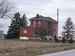
The Michaels Farmhouse, a historic site in the township | |
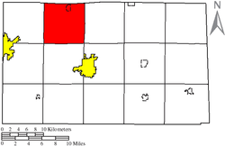 Location of Liberty Township in Seneca County. | |
| Coordinates: 41°13′5″N 83°14′23″W / 41.21806°N 83.23972°WCoordinates: 41°13′5″N 83°14′23″W / 41.21806°N 83.23972°W | |
| Country | United States |
| State | Ohio |
| County | Seneca |
| Area | |
| • Total | 36.4 sq mi (94.2 km2) |
| • Land | 36.4 sq mi (94.2 km2) |
| • Water | 0.0 sq mi (0.0 km2) |
| Elevation[1] | 719 ft (219 m) |
| Population (2000) | |
| • Total | 2,340 |
| • Density | 64.4/sq mi (24.9/km2) |
| Time zone | Eastern (EST) (UTC-5) |
| • Summer (DST) | EDT (UTC-4) |
| FIPS code | 39-43316[2] |
| GNIS feature ID | 1086949[1] |
Liberty Township is one of the fifteen townships of Seneca County, Ohio, United States. The 2000 census found 2,340 people in the township, 1,556 of whom lived in the unincorporated portions of the township.[3]
Geography
Located in the northwestern part of the county, it borders the following townships:
- Jackson Township, Sandusky County - north
- Ballville Township, Sandusky County - northeast corner
- Pleasant Township - east
- Clinton Township - southeast corner
- Hopewell Township - south
- Loudon Township - southwest corner
- Jackson Township - west
- Scott Township, Sandusky County - northwest corner
The village of Bettsville is located in northern Liberty Township, and the unincorporated community of Kansas lies in the northwestern part of the township.
Name and history
Liberty Township was organized in 1832.[4]
It is one of twenty-five Liberty Townships statewide.[5]
Government
The township is governed by a three-member board of trustees, who are elected in November of odd-numbered years to a four-year term beginning on the following January 1. Two are elected in the year after the presidential election and one is elected in the year before it. There is also an elected township fiscal officer,[6] who serves a four-year term beginning on April 1 of the year after the election, which is held in November of the year before the presidential election. Vacancies in the fiscal officership or on the board of trustees are filled by the remaining trustees.
References
- 1 2 "US Board on Geographic Names". United States Geological Survey. 2007-10-25. Retrieved 2008-01-31.
- ↑ "American FactFinder". United States Census Bureau. Archived from the original on September 11, 2013. Retrieved 2008-01-31.
- ↑ Seneca County, Ohio — Population by Places Estimates Ohio State University, 2007. Accessed 15 May 2007.
- ↑ Lang, William (1880). History of Seneca County, from the Close of the Revolutionary War to July, 1880. Transcript Printing Company. p. 549.
- ↑ "Detailed map of Ohio" (PDF). United States Census Bureau. 2000. Retrieved 2007-02-16.
- ↑ §503.24, §505.01, and §507.01 of the Ohio Revised Code. Accessed 4/30/2009.
External links
Municipalities and communities of Seneca County, Ohio, United States | ||
|---|---|---|
| Cities | 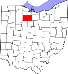 | |
| Villages | ||
| Townships | ||
| CDPs | ||
| Unincorporated communities | ||
| Ghost towns | ||
| Footnotes | ‡This populated place also has portions in an adjacent county or counties | |