Attica, Ohio
| Attica, Ohio | |
|---|---|
| Village | |
|
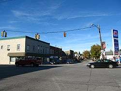
Downtown viewed from South Main Street, looking toward the intersection of Ohio 4 and U.S. 224 | |
 Location of Attica, Ohio | |
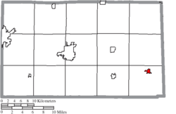 Location of Attica in Seneca County | |
| Coordinates: 41°3′53″N 82°53′5″W / 41.06472°N 82.88472°WCoordinates: 41°3′53″N 82°53′5″W / 41.06472°N 82.88472°W | |
| Country | United States |
| State | Ohio |
| County | Seneca |
| Founded | 1833 |
| Government | |
| • Type | Village council |
| • Mayor | Bryan B. Shock |
| Area[1] | |
| • Total | 0.67 sq mi (1.74 km2) |
| • Land | 0.66 sq mi (1.71 km2) |
| • Water | 0.01 sq mi (0.03 km2) |
| Elevation[2] | 948 ft (289 m) |
| Population (2010)[3] | |
| • Total | 899 |
| • Estimate (2012[4]) | 885 |
| • Density | 1,362.1/sq mi (525.9/km2) |
| Time zone | Eastern (EST) (UTC-5) |
| • Summer (DST) | EDT (UTC-4) |
| ZIP code | 44807 |
| Area code(s) | 419 |
| FIPS code | 39-02820[5] |
| GNIS feature ID | 1048470[2] |
| Website | http://www.atticaohio.us/ |
Attica is a village in Seneca County, Ohio, United States. The population was 899 at the 2010 census.
Attica was designed a Tree City USA by the National Arbor Day Foundation.
History
Attica was named after Attica, New York, the hometown of a pioneer settler.[6][7]
Geography
.jpg)
Attica is located at 41°3′53″N 82°53′5″W / 41.06472°N 82.88472°W (41.064826, -82.884790).[8]
According to the United States Census Bureau, the village has a total area of 0.67 square miles (1.74 km2), of which 0.66 square miles (1.71 km2) is land and 0.01 square miles (0.03 km2) is water.[1]
Demographics
| Historical population | |||
|---|---|---|---|
| Census | Pop. | %± | |
| 1840 | 100 | — | |
| 1870 | 370 | — | |
| 1880 | 663 | 79.2% | |
| 1890 | 682 | 2.9% | |
| 1900 | 694 | 1.8% | |
| 1910 | 719 | 3.6% | |
| 1920 | 658 | −8.5% | |
| 1930 | 783 | 19.0% | |
| 1940 | 780 | −0.4% | |
| 1950 | 858 | 10.0% | |
| 1960 | 965 | 12.5% | |
| 1970 | 1,005 | 4.1% | |
| 1980 | 865 | −13.9% | |
| 1990 | 944 | 9.1% | |
| 2000 | 955 | 1.2% | |
| 2010 | 899 | −5.9% | |
| Est. 2015 | 879 | [9] | −2.2% |
2010 census
As of the census[3] of 2010, there were 899 people, 364 households, and 266 families residing in the village. The population density was 1,362.1 inhabitants per square mile (525.9/km2). There were 428 housing units at an average density of 648.5 per square mile (250.4/km2). The racial makeup of the village was 96.3% White, 0.8% African American, 0.2% from other races, and 2.7% from two or more races. Hispanic or Latino of any race were 1.3% of the population.
There were 364 households of which 33.8% had children under the age of 18 living with them, 54.9% were married couples living together, 15.1% had a female householder with no husband present, 3.0% had a male householder with no wife present, and 26.9% were non-families. 25.0% of all households were made up of individuals and 12.1% had someone living alone who was 65 years of age or older. The average household size was 2.47 and the average family size was 2.88.
The median age in the village was 39.8 years. 25.6% of residents were under the age of 18; 7.8% were between the ages of 18 and 24; 22% were from 25 to 44; 27.1% were from 45 to 64; and 17.5% were 65 years of age or older. The gender makeup of the village was 48.8% male and 51.2% female.
2000 census
As of the census[5] of 2000, there were 955 people, 393 households, and 277 families residing in the village. The population density was 1,783.4 people per square mile (682.8/km²). There were 430 housing units at an average density of 803.0 per square mile (307.5/km²). The racial makeup of the village was 98.95% White, 0.21% Native American, 0.10% from other races, and 0.73% from two or more races. Hispanic or Latino of any race were 0.42% of the population.
There were 393 households out of which 29.3% had children under the age of 18 living with them, 57.8% were married couples living together, 10.2% had a female householder with no husband present, and 29.5% were non-families. 25.4% of all households were made up of individuals and 10.9% had someone living alone who was 65 years of age or older. The average household size was 2.43 and the average family size was 2.91.
In the village the population was spread out with 23.8% under the age of 18, 9.1% from 18 to 24, 27.0% from 25 to 44, 23.8% from 45 to 64, and 16.3% who were 65 years of age or older. The median age was 38 years. For every 100 females there were 89.5 males. For every 100 females age 18 and over, there were 91.6 males.
The median income for a household in the village was $38,529, and the median income for a family was $44,408. Males had a median income of $37,833 versus $22,969 for females. The per capita income for the village was $17,942. About 8.6% of families and 9.8% of the population were below the poverty line, including 9.4% of those under age 18 and 6.3% of those age 65 or over.
Education
Attica is in the Seneca East Local School District.[11] Until consolidation with Republic into Seneca East, the village was served by the Attica School District.
References
- 1 2 "US Gazetteer files 2010". United States Census Bureau. Archived from the original on January 24, 2012. Retrieved 2013-01-06.
- 1 2 "US Board on Geographic Names". United States Geological Survey. 2007-10-25. Retrieved 2008-01-31.
- 1 2 "American FactFinder". United States Census Bureau. Retrieved 2013-01-06.
- ↑ "Population Estimates". United States Census Bureau. Archived from the original on June 17, 2013. Retrieved 2013-06-17.
- 1 2 "American FactFinder". United States Census Bureau. Archived from the original on September 11, 2013. Retrieved 2008-01-31.
- ↑ Butterfield, Consul Willshire (1848). History of Seneca County: Containing a Detailed Narrative of the Principal Events that Have Occurred Since Its First Settlement Down to the Present Time. D. Campbell. p. 140.
- ↑ Overman, William Daniel (1958). Ohio Town Names. Akron, OH: Atlantic Press. p. 7.
- ↑ "US Gazetteer files: 2010, 2000, and 1990". United States Census Bureau. 2011-02-12. Retrieved 2011-04-23.
- ↑ "Annual Estimates of the Resident Population for Incorporated Places: April 1, 2010 to July 1, 2015". Retrieved July 2, 2016.
- ↑ "Census of Population and Housing". Census.gov. Archived from the original on May 11, 2015. Retrieved June 4, 2015.
- ↑ District website Archived January 10, 2006, at the Wayback Machine.
External links
- Seneca East Local Schools
- Seneca East Public Library
- Attica Historical Society
- The Attica Hub
- Attica Independent Fair
- Oak Ridge Festival
Municipalities and communities of Seneca County, Ohio, United States | ||
|---|---|---|
| Cities | 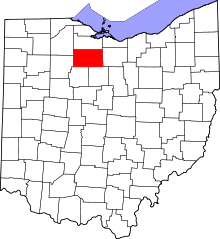 | |
| Villages | ||
| Townships | ||
| CDPs | ||
| Unincorporated communities | ||
| Ghost towns | ||
| Footnotes | ‡This populated place also has portions in an adjacent county or counties | |