Bettsville, Ohio
| Bettsville, Ohio | |
|---|---|
| Village | |
|
| |
 Location of Bettsville, Ohio | |
 Location of Bettsville in Seneca County | |
| Coordinates: 41°14′41″N 83°14′1″W / 41.24472°N 83.23361°WCoordinates: 41°14′41″N 83°14′1″W / 41.24472°N 83.23361°W | |
| Country | United States |
| State | Ohio |
| County | Seneca |
| Government | |
| • Mayor | Gary Harrison |
| • Council President | Scott Harrison |
| Area[1] | |
| • Total | 0.52 sq mi (1.35 km2) |
| • Land | 0.52 sq mi (1.35 km2) |
| • Water | 0 sq mi (0 km2) |
| Elevation[2] | 699 ft (213 m) |
| Population (2010)[3] | |
| • Total | 661 |
| • Estimate (2012[4]) | 650 |
| • Density | 1,271.2/sq mi (490.8/km2) |
| Time zone | Eastern (EST) (UTC-5) |
| • Summer (DST) | EDT (UTC-4) |
| ZIP code | 44815 |
| Area code(s) | 419 |
| FIPS code | 39-06194[5] |
| GNIS feature ID | 1064434[2] |
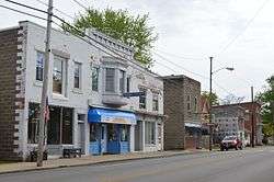
Bettsville is a village in Seneca County, Ohio, United States. The population was 661 at the 2010 census.
History
Bettsville was laid out in 1838. It was named for its founder, John Betts.[6]
Geography
Bettsville is located at 41°14′41″N 83°14′1″W / 41.24472°N 83.23361°W (41.244771, -83.233483).[7]
According to the United States Census Bureau, the village has a total area of 0.52 square miles (1.35 km2), all land.[1]
Demographics
| Historical population | |||
|---|---|---|---|
| Census | Pop. | %± | |
| 1880 | 515 | — | |
| 1890 | 513 | −0.4% | |
| 1900 | 492 | −4.1% | |
| 1910 | 486 | −1.2% | |
| 1920 | 451 | −7.2% | |
| 1930 | 656 | 45.5% | |
| 1940 | 692 | 5.5% | |
| 1950 | 687 | −0.7% | |
| 1960 | 776 | 13.0% | |
| 1970 | 833 | 7.3% | |
| 1980 | 752 | −9.7% | |
| 1990 | 752 | 0.0% | |
| 2000 | 784 | 4.3% | |
| 2010 | 661 | −15.7% | |
| Est. 2015 | 642 | [8] | −2.9% |
2010 census
As of the census[3] of 2010, there were 661 people, 281 households, and 187 families residing in the village. The population density was 1,271.2 inhabitants per square mile (490.8/km2). There were 318 housing units at an average density of 611.5 per square mile (236.1/km2). The racial makeup of the village was 97.3% White, 0.2% Native American, 1.2% Asian, 1.1% from other races, and 0.3% from two or more races. Hispanic or Latino of any race were 8.3% of the population.
There were 281 households of which 31.0% had children under the age of 18 living with them, 47.3% were married couples living together, 12.1% had a female householder with no husband present, 7.1% had a male householder with no wife present, and 33.5% were non-families. 27.8% of all households were made up of individuals and 12.1% had someone living alone who was 65 years of age or older. The average household size was 2.35 and the average family size was 2.83.
The median age in the village was 40.3 years. 23.4% of residents were under the age of 18; 9.9% were between the ages of 18 and 24; 22% were from 25 to 44; 29.1% were from 45 to 64; and 15.6% were 65 years of age or older. The gender makeup of the village was 50.7% male and 49.3% female.
2000 census
As of the census[5] of 2000, there were 784 people, 298 households, and 210 families residing in the village. The population density was 1,506.7 people per square mile (582.1/km²). There were 319 housing units at an average density of 613.0 per square mile (236.9/km²). The racial makeup of the village was 95.28% White, 0.13% African American, 0.13% Native American, 0.51% Asian, 2.93% from other races, and 1.02% from two or more races. Hispanic or Latino of any race were 5.74% of the population.
There were 298 households out of which 37.6% had children under the age of 18 living with them, 54.7% were married couples living together, 8.7% had a female householder with no husband present, and 29.5% were non-families. 23.5% of all households were made up of individuals and 9.7% had someone living alone who was 65 years of age or older. The average household size was 2.63 and the average family size was 3.12.
In the village the population was spread out with 29.1% under the age of 18, 9.8% from 18 to 24, 29.8% from 25 to 44, 19.1% from 45 to 64, and 12.1% who were 65 years of age or older. The median age was 33 years. For every 100 females there were 98.0 males. For every 100 females age 18 and over, there were 98.6 males.
The median income for a household in the village was $37,266, and the median income for a family was $39,219. Males had a median income of $30,481 versus $20,368 for females. The per capita income for the village was $15,933. About 6.5% of families and 7.4% of the population were below the poverty line, including 11.6% of those under age 18 and none of those age 65 or over.
Notable person
- James A. Norton - Member of the United States House of Representatives who was born here.
References
- 1 2 "US Gazetteer files 2010". United States Census Bureau. Archived from the original on 2012-07-14. Retrieved 2013-01-06.
- 1 2 "US Board on Geographic Names". United States Geological Survey. 2007-10-25. Retrieved 2008-01-31.
- 1 2 "American FactFinder". United States Census Bureau. Retrieved 2013-01-06.
- ↑ "Population Estimates". United States Census Bureau. Archived from the original on 2013-06-17. Retrieved 2013-06-17.
- 1 2 "American FactFinder". United States Census Bureau. Archived from the original on 2013-09-11. Retrieved 2008-01-31.
- ↑ Lang, William (1880). History of Seneca County, from the Close of the Revolutionary War to July, 1880. Transcript Printing Company. p. 549.
- ↑ "US Gazetteer files: 2010, 2000, and 1990". United States Census Bureau. 2011-02-12. Retrieved 2011-04-23.
- ↑ "Annual Estimates of the Resident Population for Incorporated Places: April 1, 2010 to July 1, 2015". Retrieved July 2, 2016.
- ↑ "Census of Population and Housing". Census.gov. Archived from the original on May 11, 2015. Retrieved June 4, 2015.
Municipalities and communities of Seneca County, Ohio, United States | ||
|---|---|---|
| Cities | 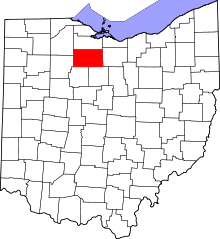 | |
| Villages | ||
| Townships | ||
| CDPs | ||
| Unincorporated communities | ||
| Ghost towns | ||
| Footnotes | ‡This populated place also has portions in an adjacent county or counties | |