Lidgerwood, North Dakota
| Lidgerwood, North Dakota | |
|---|---|
| City | |
|
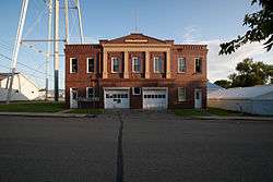
Lidgerwood City Hall | |
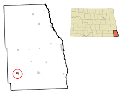 Location of Lidgerwood, North Dakota | |
| Coordinates: 46°4′29″N 97°8′59″W / 46.07472°N 97.14972°WCoordinates: 46°4′29″N 97°8′59″W / 46.07472°N 97.14972°W | |
| Country | United States |
| State | North Dakota |
| County | Richland |
| Area[1] | |
| • Total | 0.66 sq mi (1.71 km2) |
| • Land | 0.66 sq mi (1.71 km2) |
| • Water | 0 sq mi (0 km2) |
| Elevation | 1,112 ft (339 m) |
| Population (2010)[2] | |
| • Total | 652 |
| • Estimate (2015)[3] | 629 |
| • Density | 987.9/sq mi (381.4/km2) |
| Time zone | Central (CST) (UTC-6) |
| • Summer (DST) | CDT (UTC-5) |
| ZIP code | 58053 |
| Area code(s) | 701 |
| FIPS code | 38-46460 |
| GNIS feature ID | 1029882[4] |
| Website | http://www.cityoflidgerwoodnd.com/ |
Lidgerwood is a city in Richland County, North Dakota, United States. The population was 652 at the 2010 census.[5] Lidgerwood was founded in 1886. It is part of the Wahpeton, ND–MN Micropolitan Statistical Area.
Geography
Lidgerwood is located at 46°4′29″N 97°8′59″W / 46.07472°N 97.14972°W (46.074812, -97.149666).[6]
According to the United States Census Bureau, the city has a total area of 0.66 square miles (1.71 km2), all of it land.[1]
Demographics
| Historical population | |||
|---|---|---|---|
| Census | Pop. | %± | |
| 1900 | 585 | — | |
| 1910 | 1,019 | 74.2% | |
| 1920 | 1,065 | 4.5% | |
| 1930 | 1,029 | −3.4% | |
| 1940 | 1,042 | 1.3% | |
| 1950 | 1,147 | 10.1% | |
| 1960 | 1,081 | −5.8% | |
| 1970 | 1,000 | −7.5% | |
| 1980 | 971 | −2.9% | |
| 1990 | 799 | −17.7% | |
| 2000 | 738 | −7.6% | |
| 2010 | 652 | −11.7% | |
| Est. 2015 | 629 | [7] | −3.5% |
| U.S. Decennial Census[8] 2015 Estimate[3] | |||
2010 census
As of the census[2] of 2010, there were 652 people, 335 households, and 160 families residing in the city. The population density was 987.9 inhabitants per square mile (381.4/km2). There were 417 housing units at an average density of 631.8 per square mile (243.9/km2). The racial makeup of the city was 97.5% White, 2.0% Native American, and 0.5% from two or more races. Hispanic or Latino of any race were 0.9% of the population.
There were 335 households of which 17.6% had children under the age of 18 living with them, 39.4% were married couples living together, 6.9% had a female householder with no husband present, 1.5% had a male householder with no wife present, and 52.2% were non-families. 46.0% of all households were made up of individuals and 28.4% had someone living alone who was 65 years of age or older. The average household size was 1.95 and the average family size was 2.78.
The median age in the city was 51.3 years. 19% of residents were under the age of 18; 4.2% were between the ages of 18 and 24; 16.6% were from 25 to 44; 27.6% were from 45 to 64; and 32.5% were 65 years of age or older. The gender makeup of the city was 47.4% male and 52.6% female.
2000 census
As of the census of 2000, there were 738 people, 345 households, and 207 families residing in the city. The population density was 1,122.4 people per square mile (431.7/km²). There were 404 housing units at an average density of 614.4 per square mile (236.3/km²). The racial makeup of the city was 97.29% White, 1.76% Native American, 0.14% Asian, and 0.81% from two or more races. Hispanic or Latino of any race were 0.81% of the population.
There were 345 households out of which 21.2% had children under the age of 18 living with them, 47.0% were married couples living together, 7.2% had a female householder with no husband present, and 40.0% were non-families. 36.2% of all households were made up of individuals and 23.8% had someone living alone who was 65 years of age or older. The average household size was 2.14 and the average family size was 2.79.
In the city the population was spread out with 20.7% under the age of 18, 5.7% from 18 to 24, 23.3% from 25 to 44, 20.1% from 45 to 64, and 30.2% who were 65 years of age or older. The median age was 45 years. For every 100 females there were 97.9 males. For every 100 females age 18 and over, there were 97.0 males.
The median income for a household in the city was $25,887, and the median income for a family was $29,464. Males had a median income of $25,000 versus $16,818 for females. The per capita income for the city was $14,303. About 8.8% of families and 13.7% of the population were below the poverty line, including 19.5% of those under age 18 and 8.0% of those age 65 or over.
Climate
This climatic region is typified by large seasonal temperature differences, with warm to hot (and often humid) summers and cold (sometimes severely cold) winters. According to the Köppen Climate Classification system, Lidgerwood has a humid continental climate, abbreviated "Dfb" on climate maps.[9]
References
- 1 2 "US Gazetteer files 2010". United States Census Bureau. Archived from the original on January 24, 2012. Retrieved 2012-06-14.
- 1 2 "American FactFinder". United States Census Bureau. Retrieved 2012-06-14.
- 1 2 "Population Estimates". United States Census Bureau. Retrieved June 26, 2016.
- ↑ "US Board on Geographic Names". United States Geological Survey. 2007-10-25. Retrieved 2008-01-31.
- ↑ "2010 Census Redistricting Data (Public Law 94-171) Summary File". American FactFinder. United States Census Bureau. Archived from the original on July 21, 2011. Retrieved 2 May 2011.
- ↑ "US Gazetteer files: 2010, 2000, and 1990". United States Census Bureau. 2011-02-12. Retrieved 2011-04-23.
- ↑ "Annual Estimates of the Resident Population for Incorporated Places: April 1, 2010 to July 1, 2015". Retrieved July 2, 2016.
- ↑ United States Census Bureau. "Census of Population and Housing". Archived from the original on May 11, 2015. Retrieved October 31, 2013.
- ↑ Climate Summary for Lidgerwood, North Dakota
External links
Municipalities and communities of Richland County, North Dakota, United States | ||
|---|---|---|
| Cities | 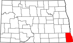 | |
| Townships |
| |
| Unincorporated communities |
| |
| Indian reservations | ||
| Footnotes | ‡This populated place also has portions in an adjacent county or counties | |