List of Indiana state historical markers in Monroe County
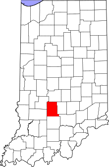
Location of Monroe County in Indiana
This is a list of the Indiana state historical markers in Monroe County.
This is intended to be a complete list of the official state historical markers placed in Monroe County, Indiana, United States by the Indiana Historical Bureau. The locations of the historical markers and their latitude and longitude coordinates are included below when available, along with their names, years of placement, and topics as recorded by the Historical Bureau. There are 8 historical markers located in Monroe County.[1]
Historical markers
| Marker title | Image | Year placed | Location | Topics |
|---|---|---|---|---|
| Stinesville Limestone Industry[2] | 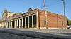 |
1996 | McGlocklin Memorial/Victor Oolitic Park near Jacks Defeat Creek in Stinesville 39°17′56″N 86°39′8″W / 39.29889°N 86.65222°W |
Business, Industry, and Labor, Buildings and Architecture |
| Ferry Bridge[3] | 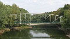 |
2000 | N. Texas Ridge Road over the West Fork of the White River, 2 miles south of Gosport 39°19′56″N 86°40′37″W / 39.33222°N 86.67694°W |
Transportation, Buildings and Architecture |
| Monroe County Courthouse[4] | 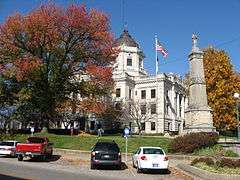 |
2001 | Southern side of the courthouse square in Bloomington 39°10′0.5″N 86°32′3″W / 39.166806°N 86.53417°W |
Buildings and Architecture, Government Institutions |
| The Colored School[5] |  |
2005 | Junction of Sixth and Washington Streets in Bloomington 39°10′3″N 86°31′55″W / 39.16750°N 86.53194°W |
African American; Black History, Education |
| Monroe County's Carnegie Library[6] | 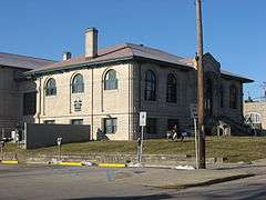 |
2007 | 202 E. 6th Street in Bloomington 39°10′3″N 86°31′54.6″W / 39.16750°N 86.531833°W |
Carnegie Libraries, Buildings and Architecture |
| Hoagy Carmichael[7] | 2007 | In front of The Gables (formerly Book Nook) at 114 S. Indiana Avenue in Bloomington 39°10′3″N 86°31′56″W / 39.16750°N 86.53222°W |
Arts and Culture | |
| Kappa Alpha Psi[8] | 2008 | The Elder Diggs Memorial at 1469 E. 17th Street in Bloomington 39°10′45″N 86°30′48″W / 39.17917°N 86.51333°W |
[none] | |
| Benjamin Banneker School[9] |  |
2008 | Westside Community Center at 930 W. Seventh Street in Bloomington 39°10′7.4″N 86°32′42.6″W / 39.168722°N 86.545167°W |
African American, Education |
See also
- List of Indiana state historical markers
- National Register of Historic Places listings in Monroe County, Indiana
References
- ↑ "Indiana Historical Markers by County". State of Indiana. Retrieved 2012-03-15.
- ↑ Stinesville Limestone Industry, Indiana Historical Bureau, n.d. Accessed 2012-03-14.
- ↑ Ferry Bridge, Indiana Historical Bureau, n.d. Accessed 2012-03-14.
- ↑ Monroe County Courthouse, Indiana Historical Bureau, n.d. Accessed 2012-03-14.
- ↑ The Colored School, Indiana Historical Bureau, n.d. Accessed 2012-03-14.
- ↑ Monroe County's Carnegie Library, Indiana Historical Bureau, n.d. Accessed 2012-03-14.
- ↑ Hoagy Carmichael, Indiana Historical Bureau, n.d. Accessed 2012-03-14.
- ↑ Kappa Alpha Psi, Indiana Historical Bureau, n.d. Accessed 2012-03-14.
- ↑ Benjamin Banneker School, Indiana Historical Bureau, n.d. Accessed 2012-03-14.
External links
Municipalities and communities of Monroe County, Indiana, United States | ||
|---|---|---|
| City | ||
| Towns | ||
| Townships | ||
| CDPs | ||
| Other unincorporated communities |
| |
This article is issued from Wikipedia - version of the 8/9/2016. The text is available under the Creative Commons Attribution/Share Alike but additional terms may apply for the media files.