List of Places of Scenic Beauty of Japan (Nagasaki)
This list is of the Places of Scenic Beauty of Japan located within the Prefecture of Nagasaki.[1]
National Places of Scenic Beauty
As of 1 December 2014, seven sites have been designated at a national level (including one *Special Place of Scenic Beauty).[2][3]
| Site | Municipality | Comments | Image | Coordinates | Type | Ref. |
|---|---|---|---|---|---|---|
| *Mount Unzen 温泉岳 Unzen-dake | Unzen/Shimabara/Minamishimabara | 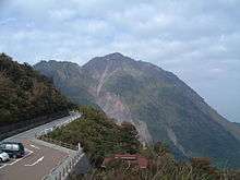 | 32°44′21″N 130°16′16″E / 32.73903249°N 130.27109336°E | 1, 3, 10 | ||
| Former Enyū-ji Gardens 旧円融寺庭園 kyū-Enyūji teien | Ōmura | 32°54′16″N 129°57′49″E / 32.90458129°N 129.96369495°E | 1 | |||
| Former Kaneishi Castle Gardens 旧金石城庭園 kyū-Kaneishi-jō teien | Tsushima | 34°12′15″N 129°17′07″E / 34.20430529°N 129.28521033°E | 1 | |||
| Ishida Castle Gotō Family Gardens 石田城五島氏庭園 Ishida-jō Gotō-shi teien | Gotō | 32°41′36″N 128°50′42″E / 32.69333348°N 128.84497131°E | 1 | |||
| Seika-en and Umegayatsu Kairaku-en 棲霞園及び梅ヶ谷津偕楽 Seika-en oyobi Umegayatsu Kairaku-en | Hirado | 33°21′00″N 129°32′44″E / 33.349942°N 129.545460°E | 1 | |||
| Miiraku 三井楽 Miiraku | Gotō | 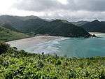 | 32°46′10″N 128°41′12″E / 32.769522°N 128.686681°E | |||
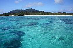
| Eight Views of Hirado 平戸領地方八竒勝 (平戸八景) Hirado ryōjikata hakkishō (Hirado hakkei) | Sasebo |  | 33°13′08″N 129°37′29″E / 33.218818°N 129.624778°E | |||
Prefectural Places of Scenic Beauty
As of 1 May 2014, one site has been designated at a prefectural level.[4][5]
| Site | Municipality | Comments | Image | Coordinates | Type | Ref. |
|---|---|---|---|---|---|---|
| Taki no Kannon 滝の観音 Taki no Kannon | Nagasaki | 32°48′01″N 129°56′13″E / 32.800334°N 129.936848°E | ||||
Municipal Places of Scenic Beauty
As of 1 May 2014, ten sites have been designated at a municipal level.[6]
| Site | Municipality | Comments | Image | Coordinates | Type | Ref. |
|---|---|---|---|---|---|---|
| Iōjima Lighthouse Park 伊王島灯台公園 Iōjima tōdai kōen | Nagasaki | designed by Richard Henry Brunton and dating to 1871, the hexagonal lower part of the first Western-style iron lighthouse in Japan was rebuilt in reinforced concrete and with a square plan after damage in the atomic blast of 1945; the upper section is original, while the current octagonal plan of the lower section dates to 2003; the lighthouse operated unmanned after 1971 | 32°42′52″N 129°45′39″E / 32.714495469932°N 129.76083236627°E | |||
| Ajiro Ripple Marks 網代の漣痕 Ajiro no renkon | Tsushima | 34°38′47″N 129°28′30″E / 34.646396°N 129.475036°E | ||||
| Nishitsuya Ripple Marks 西津屋の漣痕 Nishitsuya no renkon | Tsushima | 34°39′49″N 129°23′49″E / 34.663605°N 129.397016°E | ||||
| Summit of Mount Konpira 金比羅山頂 Konpira-sanchō | Isahaya | 32°49′23″N 130°05′39″E / 32.823147°N 130.094218°E | ||||
| Kawashimo no Ushi no Hanaguri 川下の牛のはなぐり Kawashimo no ushi no hanaguri | Isahaya | 32°45′16″N 130°00′40″E / 32.754353°N 130.011216°E | ||||
| Former Oda Family Gardens 旧小田家庭園 kyū-Oda-ke teien | Ojika | 33°11′21″N 129°03′31″E / 33.189175°N 129.058596°E | ||||

See also
- Cultural Properties of Japan
- List of Historic Sites of Japan (Nagasaki)
- List of parks and gardens of Nagasaki Prefecture
References
- ↑ "Cultural Properties for Future Generations". Agency for Cultural Affairs. Retrieved 24 December 2014.
- ↑ 史跡名勝天然記念物 [Number of Monuments of Japan by Prefecture] (in Japanese). Agency for Cultural Affairs. 1 December 2014. Retrieved 24 December 2014.
- ↑ "Database of National Cultural Properties: 史跡名勝天然記念物 (名勝, 特別名勝 長崎県)" (in Japanese). Agency for Cultural Affairs. Retrieved 24 December 2014.
- ↑ 都道府県別指定等文化財件数(都道府県分) [Number of Prefectural Cultural Properties by Prefecture] (in Japanese). Agency for Cultural Affairs. 1 May 2014. Retrieved 3 August 2014.
- ↑ 県指定名勝 [Prefectural Places of Scenic Beauty] (in Japanese). Nagasaki Prefecture. Retrieved 24 December 2014.
- ↑ 都道府県別指定等文化財件数(市町村分) [Number of Municipal Cultural Properties by Prefecture] (in Japanese). Agency for Cultural Affairs. 1 May 2014. Retrieved 3 August 2014.
External links
- (Japanese) National Cultural Properties in Nagasaki Prefecture
- (Japanese) Prefectural Cultural Properties in Nagasaki Prefecture
This article is issued from Wikipedia - version of the 12/19/2015. The text is available under the Creative Commons Attribution/Share Alike but additional terms may apply for the media files.