List of Places of Scenic Beauty of Japan (Tokushima)
This list is of the Places of Scenic Beauty of Japan located within the Prefecture of Tokushima.[1]
National Places of Scenic Beauty
As of 1 August 2014, three sites have been designated at a national level.[2][3]
| Site | Municipality | Comments | Image | Coordinates | Type | Ref. |
|---|---|---|---|---|---|---|
| Awa Kokubun-ji Gardens 阿波国分寺庭園 Awa Kokubunji teien | Tokushima | provincial temple of Awa Province; Temple 15 on the Shikoku pilgrimage | 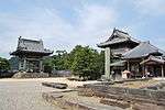 | 34°03′20″N 134°28′26″E / 34.0556645°N 134.47377247°E | 1 | |
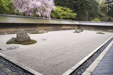
| Former Tokushima Castle Omote-Goten Gardens 旧徳島城表御殿庭園 kyū-Tokushima-jō omote-goten teien | Tokushima | | 34°04′25″N 134°33′22″E / 34.073616°N 134.556091°E | 1 | ||
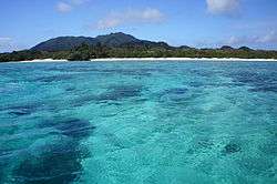
| Naruto 鳴門 Naruto | Naruto |  | 34°14′00″N 134°38′18″E / 34.23328173°N 134.63828302°E | 8, 11 | ||
Prefectural Places of Scenic Beauty
As of 1 May 2014, five sites have been designated at a prefectural level.[4][5]
| Site | Municipality | Comments | Image | Coordinates | Type | Ref. |
|---|---|---|---|---|---|---|
| Mount Tsurugi and its Flora 剣山並びに亜寒帯植物林 Tsurugi-san narabini akantai shokubutsu-rin | Mima/Naka/Miyoshi | also a Prefectural Natural Monument | 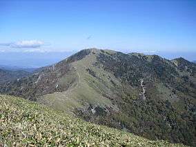 | 33°51′13″N 134°05′39″E / 33.853611°N 134.094167°E | ||
| Wajiki Line - Tsurara Kannon 鷲敷ラインおよび氷柱観音 Wajiki-rain oyobi Tsurara Kannon | Naka | 33°50′19″N 134°28′59″E / 33.838714°N 134.483020°E | ||||
| Minoda-no-Fuchi 美濃田の淵 Minoda-no-fuchi | Higashimiyoshi | also a Prefectural Natural Monument | 34°18′33″N 133°59′23″E / 34.309167°N 133.989722°E | |||
| Ganshō-ji Gardens 願勝寺庭園 Ganshōji teien | Mima | 34°03′06″N 134°03′35″E / 34.051628°N 134.059811°E | ||||
| Tamon-ji Gardens 多聞寺庭園 Tamonji teien | Tsurugi | 33°59′11″N 134°01′25″E / 33.986481°N 134.023735°E | ||||
Municipal Places of Scenic Beauty
As of 1 May 2014, fourteen sites have been designated at a municipal level.[6]
| Site | Municipality | Comments | Image | Coordinates | Type | Ref. |
|---|---|---|---|---|---|---|
| Keikoku-ji Gardens 桂国寺庭園 Keikokuji teien | Anan | 33°54′35″N 134°37′57″E / 33.909602°N 134.632419°E | ||||
| Tōrin-ji Gardens 東林寺庭園 Tōrinji teien | Mima | 34°04′20″N 134°08′45″E / 34.072306°N 134.145733°E | ||||
| Kannon-ji Shoin Gardens 観音寺書院の庭園 Kannonji shoin teien | Tokushima | 34°03′41″N 134°32′42″E / 34.061389°N 134.545028°E | ||||
| Iwado Jinja Potholes 岩戸神社甌穴 Iwado Jinja ōketsu | Yoshinogawa | 34°03′26″N 134°16′11″E / 34.057269°N 134.269714°E | ||||
| Suijin Falls 水神の滝 Suijin no taki | Yoshinogawa | 34°02′41″N 134°19′54″E / 34.044677°N 134.331722°E | ||||
| Boroboro Falls 母衣暮露滝 Boroboro no taki | Yoshinogawa | 33°59′15″N 134°12′32″E / 33.987637°N 134.208813°E | ||||
| Amanoiwado Jinja Precinct 天磐戸神社(天の岩戸神社)境内地の一部 Amanoiwado Jinja keidai chi no ichibu | Tsurugi | 33°54′19″N 134°03′48″E / 33.905159°N 134.063265°E | ||||
| Narutaki Falls 鳴滝 一区域 Narutaki ichi kuiki | Tsurugi | 33°58′40″N 134°04′28″E / 33.977816°N 134.074402°E | ||||

See also
- Cultural Properties of Japan
- List of Historic Sites of Japan (Tokushima)
- List of parks and gardens of Tokushima Prefecture
References
- ↑ "Cultural Properties for Future Generations". Agency for Cultural Affairs. Retrieved 3 August 2014.
- ↑ 史跡名勝天然記念物 [Number of Monuments of Japan by Prefecture] (in Japanese). Agency for Cultural Affairs. 1 August 2014. Retrieved 3 August 2014.
- ↑ "Database of National Cultural Properties: 史跡名勝天然記念物 (名勝, 特別名勝 徳島県)" (in Japanese). Agency for Cultural Affairs. Retrieved 3 August 2014.
- ↑ 都道府県別指定等文化財件数(都道府県分) [Number of Prefectural Cultural Properties by Prefecture] (in Japanese). Agency for Cultural Affairs. 1 May 2014. Retrieved 3 August 2014.
- ↑ "県内の文化財件数と一覧 (H26.3.27)" [Cultural Properties within the Prefecture] (in Japanese). Tokushima Prefecture. 27 March 2014. Retrieved 3 August 2014.
- ↑ 都道府県別指定等文化財件数(市町村分) [Number of Municipal Cultural Properties by Prefecture] (in Japanese). Agency for Cultural Affairs. 1 May 2014. Retrieved 3 August 2014.
External links
- (Japanese) Cultural Properties of Tokushima Prefecture
This article is issued from Wikipedia - version of the 12/19/2015. The text is available under the Creative Commons Attribution/Share Alike but additional terms may apply for the media files.