List of crossings of the Fraser River

North-facing aerial view of Dinsmore Bridge in the foreground with Sea Island Bridge and Arthur Laing Bridge in the background.

This is a list of bridges, tunnels, and other crossings of the Fraser River in the Canadian province of British Columbia. It includes both functional crossings and historic crossings which no longer exist, and lists them in sequence from the South Arm of the Fraser River at the Strait of Georgia upstream to its source. Listed separately on this page are the crossings on the Fraser River's North and Middle Arms.

This transport-related list is incomplete; you can help by expanding it.

Vancouver Lower Mainland (Strait of Georgia to Hope)

Crossing Carries Location Coordinates
Ladner Ferry (operated from 1914 to 1959),[1] replaced by George Massey Tunnel. Local Traffic Richmond and Delta 49°07′19″N 123°04′32″W / 49.12194°N 123.07556°W / 49.12194; -123.07556
George Massey Tunnel Hwy 99 Richmond and Delta 49°07′19″N 123°04′32″W / 49.12194°N 123.07556°W / 49.12194; -123.07556
Alex Fraser Bridge Hwy 91 Delta 49°09′36″N 122°56′35″W / 49.16000°N 122.94306°W / 49.16000; -122.94306
Annacis Island Swing Bridge Local Traffic New Westminster and Annacis Island 49°11′11″N 122°55′57″W / 49.18639°N 122.93250°W / 49.18639; -122.93250
SkyBridge SkyTrain Expo Line New Westminster and Surrey 49°12′20″N 122°53′48″W / 49.20556°N 122.89667°W / 49.20556; -122.89667
Marpole Railway Bridge CPR Vancouver and Richmond 49°11′58″N 123°7′36″W / 49.19944°N 123.12667°W / 49.19944; -123.12667
Pattullo Bridge Hwy 1A/Hwy 99A New Westminster and Surrey 49°12′27″N 122°53′40″W / 49.20750°N 122.89444°W / 49.20750; -122.89444
New Westminster Bridge Railway New Westminster and Surrey 49°12′29″N 122°53′38″W / 49.20806°N 122.89389°W / 49.20806; -122.89389
Port Mann Bridge Trans-Canada Highway Coquitlam and Surrey 49°13′14″N 122°48′45″W / 49.22056°N 122.81250°W / 49.22056; -122.81250
Barnston Island Ferry Local Traffic Port Kells, Surrey 49°11′31″N 122°43′30″W / 49.19194°N 122.72500°W / 49.19194; -122.72500
Golden Ears Bridge Golden Ears Way Langley and Maple Ridge 49°11′47″N 122°39′56″W / 49.19639°N 122.66556°W / 49.19639; -122.66556 (Approx)
Albion Ferry

Permanently closed as of July 31, 2009. Replaced by the new Golden Ears bridge.

Passengers and Vehicles Langley and Maple Ridge 49°10′52″N 122°33′50″W / 49.18111°N 122.56389°W / 49.18111; -122.56389
Mission Bridge Hwy 11 Mission and Abbotsford 49°07′25″N 122°18′21″W / 49.12361°N 122.30583°W / 49.12361; -122.30583
Mission Railway Bridge CPR Mission 49°07′34″N 122°18′02″W / 49.12611°N 122.30056°W / 49.12611; -122.30056
Agassiz-Rosedale Bridge Hwy 9 South of Agassiz, British Columbia 49°12′22″N 121°46′37″W / 49.20611°N 121.77694°W / 49.20611; -121.77694
Water Avenue Bridge Trans-Canada Highway Hope-Haig 49°23′10″N 121°27′08″W / 49.38611°N 121.45222°W / 49.38611; -121.45222
Arthur Laing Bridge (foreground), Oak Street Bridge (middle), and North Arm Bridge (background). Photographed from SkyTrain on the Airport branch of the Canada Line.

Middle Arm

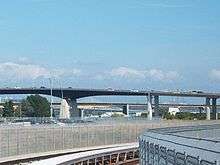
This is a list of crossings of the Middle Arm of the Fraser River from the Strait of Georgia to the North Arm of the Fraser River at approximately mile 4.6.

Crossing Carries Location Coordinates
Middle Arm Bridge SkyTrain Canada Line Richmond and Sea Island 49°11′47″N 123°08′06″W / 49.19639°N 123.13500°W / 49.19639; -123.13500
No. 2 Road Bridge No. 2 Road / Russ Baker Way 49°10′43″N 123°08′55″W / 49.17861°N 123.14861°W / 49.17861; -123.14861
Dinsmore Bridge Gilbert Road 49°10′33″N 123°09′26″W / 49.17583°N 123.15722°W / 49.17583; -123.15722
Moray Bridge Sea Island Way 49°11′31″N 123°08′13″W / 49.19194°N 123.13694°W / 49.19194; -123.13694
Sea Island Bridge Bridgeport Road 49°11′33″N 123°08′12″W / 49.19250°N 123.13667°W / 49.19250; -123.13667

There is also a swing bridge across Canoe Pass, the southernmost stream of the Fraser Delta, between Ladner and Westham Island. It is a single track road bridge, upgraded by TransLink (its current owner) to 50 tonnes GVW.

North Arm

This is a list of crossings of the North Arm of the Fraser River from the Strait of Georgia to the main body of the Fraser River at approximately mile 16.5.

Crossing Carries Location Coordinates
Arthur Laing Bridge Grant McConachie Way Sea Island and Vancouver 49°11′57″N 123°08′09″W / 49.19917°N 123.13583°W / 49.19917; -123.13583 opened August 1975
Marpole Bridge Canadian Pacific Railway Richmond and Vancouver 49°11′59″N 123°07′37″W / 49.19972°N 123.12694°W / 49.19972; -123.12694 opened 1967
Oak Street Bridge Hwy 99 Richmond and Vancouver 49°11′59″N 123°07′32″W / 49.19972°N 123.12556°W / 49.19972; -123.12556 opened June 1957
Fraser Street Bridge Fraser Street Richmond and Vancouver 49°11′53″N 123°05′28″W / 49.19806°N 123.09111°W / 49.19806; -123.09111 1905-1974
Knight Street Bridge Knight Street Richmond and Vancouver 49°12′08″N 123°04′39″W / 49.20222°N 123.07750°W / 49.20222; -123.07750 opened 1974
CNR Bridge Canadian National Railway Richmond and Burnaby 49°10′59″N 122°59′17″W / 49.18306°N 122.98806°W / 49.18306; -122.98806
Queensborough Bridge Hwy 91A Queensborough and New Westminster 49°11′46″N 122°56′49″W / 49.19611°N 122.94694°W / 49.19611; -122.94694 opened 1960
Railway Bridge Rail Queensborough and New Westminster 49°11′50″N 122°55′24″W / 49.19722°N 122.92333°W / 49.19722; -122.92333
North Arm Bridge SkyTrain Canada Line Vancouver and Richmond 49°12′09″N 123°6′57″W / 49.20250°N 123.11583°W / 49.20250; -123.11583 August 14, 2009 (pedestrian-bike walkway), August 17, 2009 (Canada Line tracks)

Fraser Canyon (Hope to Williams Lake)

Crossing Carries Location Coordinates
Alexandra Bridge (modern) Trans-Canada Highway Alexandra Lodge-Spuzzum 49°42′06″N 121°24′36″W / 49.7016°N 121.4101°W / 49.7016; -121.4101
Alexandra Bridge (original)
Cariboo Road (not in use, heritage site); current bridge is the second, built by the Royal Engineers, the first was built/contracted by Joseph Trutch Alexandra Lodge-Spuzzum 49°42′27″N 121°25′00″W / 49.70750°N 121.41667°W / 49.70750; -121.41667
Hell's Gate Suspension Bridge Pedestrian suspension bridge Hell's Gate 49°46′48″N 121°26′49″W / 49.78000°N 121.44694°W / 49.78000; -121.44694
North Bend-Boston Bar Bridge Local use (access to North Bend) & Logging Road Boston Bar 49°52′37″N 121°26′37″W / 49.877°N 121.4436°W / 49.877; -121.4436
Boston Bar Aerial Ferry Aerial Ferry (no longer in use) Boston Bar 49°42′27″N 121°25′00″W / 49.70750°N 121.41667°W / 49.70750; -121.41667
Siska CPR Bridge Canadian Pacific Railway Siska 50°08′55″N 121°34′42″W / 50.1485°N 121.5784°W / 50.1485; -121.5784
Siska CNR Bridge Canadian National Railway Siska 50°09′05″N 121°34′52″W / 50.1515°N 121.5811°W / 50.1515; -121.5811
Lytton CNR Fraser Bridge Canadian National Railway
(includes pedestrian walkway)
Lytton 50°13′27″N 121°35′06″W / 50.2243°N 121.5849°W / 50.2243; -121.5849
Lytton Ferry Reaction-Cable Ferry Lytton 50°14′51″N 121°35′30″W / 50.2474°N 121.5918°W / 50.2474; -121.5918
Lillooet PGE Bridge Pacific Great Eastern Railway (demolished 1948) Lillooet 50°40′48″N 121°55′25″W / 50.68000°N 121.92361°W / 50.68000; -121.92361
Bridge of the Twenty-Three Camels Hwy 99 Lillooet 50°41′02″N 121°55′44″W / 50.6838°N 121.9289°W / 50.6838; -121.9289
Miller's Ferry Old Cariboo Road (in use until the 1880s) Lillooet 50°42′40″N 121°54′41″W / 50.71111°N 121.91139°W / 50.71111; -121.91139
Lillooet Suspension Bridge Old Highway 12
(not in use, heritage site)
Lillooet 50°42′41″N 121°54′41″W / 50.7115°N 121.9114°W / 50.7115; -121.9114
Lillooet Railway Bridge Canadian National Railway Lillooet 50°43′04″N 121°54′50″W / 50.7178°N 121.9139°W / 50.7178; -121.9139
Bridge River Bridge Old Cariboo Road (in use until the 1870s) Lillooet 50°45′02″N 121°55′51″W / 50.75056°N 121.93083°W / 50.75056; -121.93083
Pavilion Ferry Aerial Ferry (not in use) Pavilion-West Pavilion 50°52′14″N 121°52′08″W / 50.87056°N 121.86889°W / 50.87056; -121.86889
Big Bar Ferry Reaction-Cable Ferry (year-round)
Unnumbered Ranch Road
Big Bar Creek (Kostering) 51°11′00″N 122°07′59″W / 51.18333°N 122.13306°W / 51.18333; -122.13306
Dog Creek Bridge Unnumbered Ranch Road Gang Ranch-Dog Creek 51°31′39″N 122°17′05″W / 51.5275°N 122.2848°W / 51.5275; -122.2848
Sheep Creek Bridge Hwy 20 Riske Creek (18 km SW of Williams Lake 51°59′02″N 122°16′32″W / 51.9838°N 122.2755°W / 51.9838; -122.2755
Chimney Creek Bridge Chimney Creek Indian Reserve No. 5 (NW of Williams Lake 52°04′00″N 122°16′00″W / 52.06667°N 122.26667°W / 52.06667; -122.26667

Soda Creek to Greater Prince George

Crossing Carries Location Coordinates
Rudy Johnston Bridge Buckskin Road Near Soda Creek 52°15′37″N 122°15′51″W / 52.2602°N 122.2643°W / 52.2602; -122.2643
Moffat Bridge Moffat Bridge Approach/Marsh Drive Quesnel 52°58′29″N 122°30′00″W / 52.9746°N 122.5°W / 52.9746; -122.5
Pedestrian Bridge Pedestrians Quesnel 52°58′32″N 122°30′01″W / 52.9755°N 122.5003°W / 52.9755; -122.5003
Simon Fraser Bridge Hwy 97 Prince George 53°53′25″N 122°44′52″W / 53.8904°N 122.7478°W / 53.8904; -122.7478
Yellowhead Bridge Hwy 16 Prince George 53°54′37″N 122°43′24″W / 53.9102°N 122.7234°W / 53.9102; -122.7234
Prince George CNR Bridge Canadian National Railway Prince George 53°54′48″N 122°43′03″W / 53.9134°N 122.7175°W / 53.9134; -122.7175
Rail Bridge Railway Prince George 53°54′54″N 122°41′27″W / 53.915°N 122.6907°W / 53.915; -122.6907
Road Bridge Loopol Road Near Prince George 53°58′45″N 122°40′33″W / 53.9792°N 122.6759°W / 53.9792; -122.6759

Robson Valley (McGregor to Yellowhead Pass)

Crossing Carries Location Coordinates
Road Bridge Upper Fraser Road Near McGregor 54°04′37″N 121°50′53″W / 54.077°N 121.8481°W / 54.077; -121.8481
Road Bridge Morkil Forest Service Road Near Loos 53°35′27″N 120°41′20″W / 53.5907°N 120.689°W / 53.5907; -120.689
Highway Bridge Hwy 16 McBride 53°18′07″N 120°08′24″W / 53.3019°N 120.1399°W / 53.3019; -120.1399
Road Bridge Dunster Station Road Dunster 53°08′35″N 119°50′06″W / 53.1431°N 119.8349°W / 53.1431; -119.8349
Road Bridge Blackman Road Near Tete Jaune Cache 52°58′29″N 119°26′13″W / 52.9747°N 119.4369°W / 52.9747; -119.4369
Highway Bridge Hwy 5 Near Tete Jaune Cache 52°58′27″N 119°25′30″W / 52.9743°N 119.425°W / 52.9743; -119.425
Railway Bridge Canadian National Railway Mount Robson Provincial Park 53°00′03″N 119°03′18″W / 53.0009°N 119.0551°W / 53.0009; -119.0551
Railway Bridge Canadian National Railway Mount Robson Provincial Park 52°59′16″N 119°00′36″W / 52.9878°N 119.0101°W / 52.9878; -119.0101
Highway Bridge Hwy 16 Mount Robson Provincial Park 52°52′02″N 118°40′24″W / 52.8673°N 118.6734°W / 52.8673; -118.6734
Highway Bridge Hwy 16 Mount Robson Provincial Park 52°51′10″N 118°36′23″W / 52.8527°N 118.6065°W / 52.8527; -118.6065

See also

References

  1. Gyarmati, Sandor (23 May 2009). "Tunnel sends river ferry to drydock". Delta Optimist. LMP Publications. Retrieved 9 December 2015.
This article is issued from Wikipedia - version of the 11/14/2016. The text is available under the Creative Commons Attribution/Share Alike but additional terms may apply for the media files.