List of islands within the Murray River in South Australia
List of islands within the Murray River in South Australia is a list of islands located within the watercourse of the Murray River within the Australian state of South Australia from the mouth of the river at Encounter Bay in the south to the borders with the states of New South Wales and Victoria in the east including the following lakes located adjacent to the river's mouth - Coorong, Lake Albert and Lake Alexandrina.
Coorong
The following list includes islands (listed from west to east) in the Coorong as well as the following two channels connecting it to Port Pullen at the Murray Mouth - the Coorong Channel and the Tauwitchere Channel. As of 2014, all of the islands in the following list were within the boundary of the Coorong National Park.[1][2][3][4][5][6]
Lake Albert
| Name | Coordinates | Remarks |
|---|---|---|
| Bascombe Island | 35°43′35″S 139°15′49″E / 35.72648039°S 139.26348163°E | Island is located in a bay at the south end of the lake also known as Bascombe Bay [2][7][28] |
Lake Alexandrina
The following is a list of islands (from west to east) within Lake Alexandrina and including the group of islands at the southern end of the lake.[6]
| Name | Coordinates | Remarks |
|---|---|---|
| Goose Island | 35°29′30″S 138°49′53″E / 35.49172152°S 138.83152770°E | An island that was inundated by the water level rise caused by the construction of the barrages in the 1930s. It lies within the boundaries of the Currency Creek Game Reserve.[29] |
| Billygoat Islands | 35°29′18″S 138°50′11″E / 35.48844308°S 138.83643637°E | It is reported as being a group of small islands of which many were inundated by the water level rise in the river system caused by the construction of the barrages in the 1930s. It lies within the boundaries of the Currency Creek Game Reserve.[30] |
| Reedy Island | 35°31′53″S 138°50′39″E / 35.531270°S 138.844230°E | Island located in the Goolwa Channel on the south side of Hindmarsh Island within the boundary of the Coorong National Park.[1][31] |
| Rushy Island | 35°32′08″S 138°50′59″E / 35.535440°S 138.849680°E | Island located in the Goolwa Channel on the south side of Hindmarsh Island within the boundary of the Coorong National Park.[1][32] |
| Hindmarsh Island | 35°30′58″S 138°52′34″E / 35.51618332°S 138.87616566°E | [1][2][33] |
| Bird Island | 35°33′10″S 138°53′44″E / 35.55288311°S 138.89542664°E | Island located in the Coorong Channel on the south side of Hindmarsh Island within the boundary of the Coorong National Park. Also, known as Gull Island.[1][2][34] |
| Varcoe Island | 35°32′31″S 138°54′04″E / 35.541960°S 138.901010°E | Island located in Mundoo channel between Hindmarsh and Mundoo Islands.,[1][35] |
| Lucerne Island | 35°31′54″S 138°55′31″E / 35.53156940°S 138.92519926°E | [1][4][36] |
| Mundoo Island | 35°32′47″S 138°56′02″E / 35.546510°S 138.9339°E | [1][2][37] |
| Goose Island | 35°30′05″S 138°56′09″E / 35.50127164°S 138.93570995°E | Island located east of the town of Clayton Bay.[1][38] |
| Goat Island | 35°30′15″S 138°56′37″E / 35.504110°S 138.943560°E | Island located east of town of Clayton Bay.[1][39] |
| Ewe Island | 35°33′23″S 138°56′49″E / 35.556260°S 138.947020°E | According to an atlas published in 1877, it and Long Island were considered to be one island known as Reedy Island. [1][2][40][41] |
| Rat Island | 35°31′13″S 138°57′33″E / 35.520140°S 138.959110°E | Also called Ram Island.[1][42][43] |
| Long Island | 35°32′15″S 138°59′06″E / 35.537480°S 138.98487346°E | Also known as Ram Island and as Grindstone Island. According to an atlas published in 1877, it and Ewe Island were considered to be one island known as Reedy Island.[1][2][44][45] |
| Tauwitchere Island | 35°34′28″S 138°59′22″E / 35.574560°S 138.989540°E | Island is reported as also being named Towagery, Towatchery and Talwadjeri Island and as having an area of 144 hectares (356 acres). [46][47] |
| Myrtle Island | 35°34′08″S 138°59′32″E / 35.5689°S 138.992280°E | Island located within the Mud Islands Game Reserve.[48][49] |
| Snake Island | 35°33′41″S 138°59′49″E / 35.56143004°S 138.99698025°E | [3][50][51] |
| Mud Island | 35°33′51″S 139°00′43″E / 35.564130°S 139.011910°E | Island reported as having an area of 17 hectares (43 acres). It lies within the boundaries of the Mud Island Game Reserve.[52] |
| Reedy Island No 2 | 35°33′22″S 139°00′43″E / 35.5560°S 139.012070°E | [4][51][53] |
| Pomanda Island | 35°24′58″S 139°18′29″E / 35.41600826°S 139.30799221°E | Island located adjacent of the channel of the Murray River immediately south of its entry into Lake Alexandrina.[54][55] |
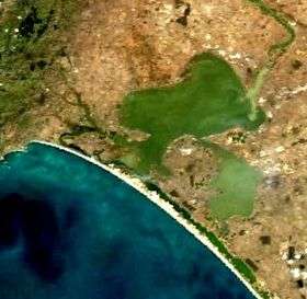
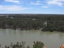
 Aerial view from the east showing island system adjoining Murray Mouth including locations of barrages (State Library of South Australia - PRG-1258/2/546) |
 Aerial photo of Goolwa, South Australia with Hindmarsh Island on the left side of image |
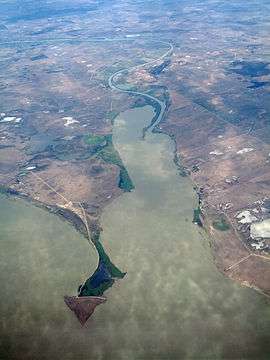 Pomanda Island (at bottom of image) |
Wellington to Morgan
The following is a list of islands (from south to north) within the river’s channel between the town of Wellington and the town of Morgan.
| Name | Coordinates | Remarks |
|---|---|---|
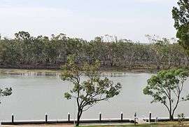
| Miss Gawler Island | 35°08′50″S 139°18′35″E / 35.14728707°S 139.30978°E | Island located south east of the city of Murray Bridge and is located beneath the Swanport Bridge.[56][57] |
| Long Island | 35°07′48″S 139°17′59″E / 35.130070°S 139.299730°E | The island located immediately opposite Murray Bridge and is within the boundaries of the Long Island Recreation Park. The island is considered by the Ngarrindjeri, the Australian Aboriginal people associated with the locality, to be “highly sensitive” (i.e. “high cultural and/or (sic) heritage importance”).[56][58][59] |
| Nott Island | 34°22′44″S 139°37′30″E / 34.37875552°S 139.62503174°E | Island located about 3 kilometres (1.9 mi) south of the town of Blanchetown.[60][61] |
| Reedy Island | 34°17′43″S 139°38′12″E / 34.29535698°S 139.63662083°E | Island located about 7 kilometres (4.3 mi) north of Blanchetown, immediately across the river from the Roonka Conservation Park and immediately south of Julia Island.[62][63] |
| Julia Island | 34°17′30″S 139°38′24″E / 34.291560°S 139.639870°E | Island located immediately adjacent to Reedy Island and across the river from the Roonka Conservation Park.[62][64] |
.jpg) Cattle grazing at Long Island, circa 1900 (State Library of South Australia (B 26826) |
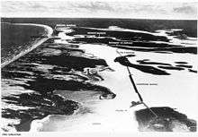
.jpeg) Aerial view of Murray Bridge from the south including the north end of Long Island, circa 1920 (State Library of South Australia B 11533) |
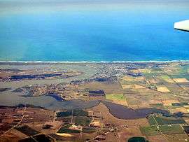
 Miss Gawler Island is located below the Swanport Bridge |
Morgan to the border
The following is a list of islands (from west to east) within the river’s channel between the town of Morgan and the borders with New South Wales and Victoria.
| Name | Coordinates | Remarks |
|---|---|---|
| Hart Island | 34°10′33″S 140°03′17″E / 34.17590386°S 140.05461270°E | Island located east of the town of Waikerie. Previously known as Wigleys Island. The current name has been in use since at least 1888, possibly named after J.Hart, a pastoralist.[65][66] |
| Sandy Island | 34°10′57″S 140°05′04″E / 34.182510°S 140.084360°E | The existence of this island is based on an entry in an atlas dated 1877. As of 2015, the responsible government agency reported that the island is not indicated on "current mapping" within the locality. [67] |
| Ball Island | 34°10′59″S 140°20′27″E / 34.183180°S 140.340790°E | [68] |
| Thurk Island | 34°13′05″S 140°22′02″E / 34.21804118°S 140.36710836°E | Island located in the channel east of Kingston-on-Murray opposite the Loch Luna Game Reserve. Previously known as Chambers Island or Isle.[69][70] |
| Moorook Island | 34°17′13″S 140°22′12″E / 34.28693766°S 140.36996279°E | Island located opposite to the town of Moorook. Also known as Moorook Isle and Moorik Isle.[69][71] |
| Nynes Island | 34°19′58″S 140°23′11″E / 34.33285356°S 140.38643302°E | Previously known as Pyap Island.[72][73] |
| Forbys Island | 34°26′36″S 140°30′00″E / 34.44320925°S 140.50006195°E | [74][75] |
| Katarapko Island | 34°24′20″S 140°33′22″E / 34.40566248°S 140.55608657°E | Island is located within the extent of the Murray River National Park. Previously known as Cragg Island.[76][77][78] |
| Kapunda Island | 34°26′54″S 140°33′36″E / 34.44846740°S 140.55998258°E | Located in the main river channel to the immediate north-west of Loxton and within the Kapunda Island Conservation Park. In 1994, the island was reported as having an area of 1 hectare (2.5 acres) and as being “only accessible by boat.”[77][79][80][81] |
| Rilli Island | 34°23′37″S 140°34′40″E / 34.39356053°S 140.57769733°E | Located within the extent of the Rilli Island Conservation Park. Previously known as Riley Island and also referred to as Rilli Isle. In 1994, the island was as having an area of 4 hectares (9.9 acres) and as being “only accessible by boat except during low river flows when” it is “accessible by foot, from the south bank of the River…”[77][82][83][81] |
| Media Island | 34°25′46″S 140°35′17″E / 34.429540°S 140.588180°E | Island located to the south east of Loxton and within the extent of Media Island Conservation Park. Previously known as Medea Island and also referred to as Media Isle. In 1994, the island was reported as having an area of 1 hectare (2.5 acres) and as being “only accessible by boat except during low river flows when” it is “accessible by foot, from the south bank of the River…”[77][84][85][81] |
| Punkey Island | 34°15′15″S 140°42′24″E / 34.25412471°S 140.70654564°E | Also known as Penky Island.[86][87] |
| Cemlell Island | 34°14′20″S 140°42′27″E / 34.238870°S 140.707420°E | Also known as Gumlell Island.[86][88] |
| Muklemuk Island | 34°14′11″S 140°43′52″E / 34.236460°S 140.731150°E | Also known as Muckle Muk Island.[86][89] |
| Reny Island | 34°03′33″S 140°44′09″E / 34.05910722°S 140.73577007°E | [90][91][92] |
| Nelbuck Island | 34°06′05″S 140°44′47″E / 34.10144157°S 140.74633239°E | Island which adjoins Bulyong Island, was gazetted on 19 September 1996 by the direction of the state's Minister of Environment. |
| Nelwart Island | 34°12′55″S 140°44′56″E / 34.215280°S 140.749°E | Also called Nelwart Island [82][94] |
| Goat Island | 34°11′14″S 140°45′08″E / 34.18720150°S 140.75220533°E | [95][96] |
| Bulyong Island | 34°07′21″S 140°45′51″E / 34.122540°S 140.764160°E | Island located within the extent of the Murray River National Park.[90][97][98] |
| Kylie Island | 34°08′12″S 140°45′51″E / 34.13679281°S 140.76420893°E | Name derived from the surname of the land owners.[99] |
| Causeway Island | 34°10′08″S 140°45′56″E / 34.168880°S 140.765420°E | [86][100] |
| Longwang Island | 34°08′53″S 140°46′15″E / 34.14815204°S 140.77084040°E | [101][90][102] |
| Sandy Island | 34°15′20″S 140°47′34″E / 34.255650°S 140.7927°E | Also known as Sandy Ridge.[103] |
| Hunchee Island | 34°03′07″S 140°47′36″E / 34.051840°S 140.7933°E | [104][105] |
| Little Hunchee Island | 34°01′57″S 140°49′28″E / 34.03257899°S 140.82436519°E | Island located partly within the Chowilla Game Reserve.[104][105][106] |
| Chowilla Island | 33°59′19″S 140°52′44″E / 33.98870183°S 140.87895483°E | Island located within the Chowilla Game Reserve.[107][108][109] |
| Monoman Island | 33°59′19″S 140°52′44″E / 33.98870183°S 140.87895483°E | Island located within the Chowilla Game Reserve.[108][110][111] |
| Reedy Island | 33°57′51″S 140°54′15″E / 33.964280°S 140.9043°E | Island located within the Chowilla Game Reserve.[112][113] |
| Boat Creek Island | 33°57′09″S 140°54′45″E / 33.952530°S 140.912580°E | Island located within the Chowilla Game Reserve.[108][112][114] |
| Slaney Island | 33°57′00″S 140°55′51″E / 33.949990°S 140.930850°E | Island located within the Chowilla Game Reserve. Also known as Stanley Island.[108][115][116] |
| Newena Island | 33°57′44″S 140°55′55″E / 33.96218883°S 140.93196606°E | Island located within the Chowilla Game Reserve; also known as the Isle of Man.[115][117] |
| Punkah Island | 33°56′45″S 140°58′04″E / 33.945940°S 140.967860°E | Island located within the Chowilla Game Reserve.[115][118] |
| Wilpena Island | 33°59′50″S 140°59′00″E / 33.99718402°S 140.98329388°E | Island located within the Chowilla Game Reserve.[108][119][120] |
| Grand Junction Island | 33°58′50″S 140°59′22″E / 33.980640°S 140.989340°E | Island located within the Chowilla Game Reserve.[108][121][122] |
| Hypurna Island | 34°00′12″S 140°59′57″E / 34.00344271°S 140.99915737°E | Island which is partly located within the Chowilla Game Reserve, also straddles the border with New South Wales.[108][123][124] |
 Hunchee Island viewed from Headings Cliff on the opposite of the Murray River. |
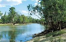
 Katarapko Island as viewed from Loxton. |
 View of Punkah Creek showing both Punkah Island and the mainland. |
See also
Citations and references
Citations
- 1 2 3 4 5 6 7 8 9 10 11 12 13 BIA, 2005, page 27
- 1 2 3 4 5 6 7 DEWNR, 2014a
- 1 2 3 4 5 6 7 8 DEWNR, 2014b
- 1 2 3 4 5 6 7 8 9 10 11 12 13 14 15 16 DEWNR, 2014c
- 1 2 DEWNR, 2014d
- 1 2 DMH, 1985, chart 9
- 1 2 BIA, 2005, page 31
- ↑ DPTI, Search result for Sam Island (record no. SA0035074), 2015
- ↑ DPTI, Search result for Needles Island (record no. SA0034856), 2015
- ↑ DPTI, Search result for Goat Island (record no. SA0026789), 2015
- ↑ DPTI, Search result for Snake Island (record no. SA0035115), 2015
- ↑ DPTI, Search result for Rabbit Island (record no. SA0034979), 2015
- ↑ DPTI, Search result for Bluff Island (record no. SA0007754), 2015
- ↑ DPTI, Search result for Bull Island (record no. SA0056805), 2015
- ↑ DPTI, Search result for Cow Island (record no. SA0016523), 2015
- ↑ DPTI, Search result for Long Island (record no. SA0033818), 2015
- ↑ DPTI, Search result for Round Island (record no. SA0035054), 2015
- ↑ DPTI, Search result for Swan Island (record no. SA0014524), 2015
- ↑ DPTI, Search result for Stony Well Island (record no. SA0014525), 2015
- ↑ DPTI, Search result for Cattle Island (record no. SA0012910), 2015
- ↑ DPTI, Search result for Teal Island (record no. SA0035196), 2015
- ↑ DPTI, Search result for North Pelican Island (record no. SA0034870), 2015
- ↑ DPTI, Search result for Halfway Island (record no. SA0028944), 2015
- ↑ DPTI, Search result for Pelican Island (record no. SA0034917), 2015
- ↑ DPTI, Search result for Mellor Island (record no. SA0034750), 2015
- ↑ DPTI, Search result for Seagull Island (record no. SA0035084), 2015
- ↑ DPTI, Search result for Wild Dog Island (record no. SA0035332), 2015
- ↑ DPTI, Search result for Bascombe Island (record no. SA0005074), 2015
- ↑ DPTI, Search result for Goose Island (record no. SA0004115), 2015
- ↑ DPTI, Search result for Billygoat Islands (record no. SA0004116), 2015
- ↑ DPTI, Search result for Reedy Island (record no. SA0037142), 2015
- ↑ DPTI, Search result for Rushy Island (record no. SA0059654), 2015
- ↑ DPTI, Search result for Hindmarsh Island (record no. SA0030657), 2015
- ↑ DPTI, Search result for Bird Island (record no. SA0006607), 2015
- ↑ DPTI, Search result for Varcoe Island (record no. SA0012909), 2015
- ↑ DPTI, Search result for Lucerne Island (record no. SA0041615), 2015
- ↑ DPTI, Search result for Mundoo Island (record no. SA0047690), 2015
- ↑ DPTI, Search result for Goose Island (record no. SA0027022), 2015
- ↑ DPTI, Search result for Goat Island (record no. SA0026791), 2015
- ↑ DPTI, Search result for Ewe Island (record no. SA0023158), 2015
- ↑ DPTI, Search result for Reedy Island (record no. SA0034994), 2015
- ↑ DPTI, Search result for Rat Island (record no. SA0057873), 2015
- ↑ DPTI, Search result for Grindstone Island (record no. SA0003913), 2015
- ↑ DPTI, Search result for Long Island (record no. SA0033820), 2015
- ↑ DPTI, Search result for Reedy Island (record no. SA0034994), 2015
- ↑ DPTI, Search result for Tauwitchere Island (record no. SA0035193), 2015
- ↑ BIA, 2005, page 30
- ↑ DPTI, Search result for Myrtle Island (record no. SA0034839), 2015
- ↑ BIA, 2005, page 38
- ↑ DPTI, Search result for Snake Island (record no. SA0035116), 2015
- 1 2 BIA, 2005, page 30
- ↑ DPTI, Search result for Mud Island (record no. SA0034820), 2015
- ↑ DPTI, Search result for Reedy Island No 2 (record no. SA0034995), 2015
- ↑ DPTI, Search result for Pomanda Island (record no. SA0056221), 2015
- ↑ BIA, 2005, page 29
- 1 2 BIA, 2005, page 61
- ↑ DPTI, Search result for Long Island (record no. SA0040326), 2015
- ↑ DPTI, Search result for Long Island (record no. SA0041196), 2015
- ↑ "Kungun Ngarrindjeri Yunnan Agreement" (PDF). The Rural City of Murray Bridge. pp. 9 & 11. Retrieved 25 August 2015.
- ↑ BIA, 2005, page 95
- ↑ DPTI, Search result for Nott Island (record no. SA0051023), 2015
- 1 2 BIA, 2005, pages 95- 96
- ↑ DPTI, Search result for Reedy Island (record no. SA0058334), 2015
- ↑ DPTI, Search result for Julia Island (record no. SA0033236), 2015
- ↑ BIA, 2005, pages 114-115
- ↑ DPTI, Search result for Hart Island (record no. SA0029494), 2015
- ↑ DPTI, Search result for Sandy Island (record no. SA0059785), 2015
- ↑ DPTI, Search result for Ball Island (record no. SA0004351), 2015
- 1 2 BIA, 2005, page 123
- ↑ DPTI, Search result for Thurk Island (record no. SA0066369), 2015
- ↑ DPTI, Search result for Moorook Island (record no. SA0023380), 2015
- ↑ BIA, 2005, page 126
- ↑ DPTI, Search result for Nynes Island (record no. SA0051375), 2015
- ↑ BIA, 2005, page 130
- ↑ DPTI, Search result for Forbys Island (record no. SA0024536), 2015
- ↑ BIA, 2005, page 131
- 1 2 3 4 DENR, 1994, pages 7-8
- ↑ DPTI, Search result for Kataropko Island (record no. SA0023380), 2015
- ↑ BIA, 2005, page 132
- ↑ DPTI, Search result for Kapunda Island (record no. SA0034114), 2015
- 1 2 3 DENR, 1994, page vi
- 1 2 BIA, 2005, pages 133 & 134
- ↑ DPTI, Search result for Rilli Island (record no. SA0058510), 2015
- ↑ BIA, 2005, page 133
- ↑ DPTI, Search result for Media Island (record no. SA0044069), 2015
- 1 2 3 4 BIA, 2005, page 140
- ↑ DPTI, Search result for Punkey Island (record no. SA0054339), 2015
- ↑ DPTI, Search result for Cumlell Island (record no. SA0017257), 2015
- ↑ DPTI, Search result for Muklemuk Island (record no. SA0047406), 2015
- 1 2 3 DENR, 1994, pages 69-70
- ↑ BIA, 2005, page 145
- ↑ DPTI, Search result for Reny Island (record no. SA0040854), 2015
- ↑ DPTI, Search result for Nelbuck Island (record no. SA0003793), 2015
- ↑ DPTI, Search result for Nelwort Island (record no. SA0049149), 2015
- ↑ BIA, 2005, page 142
- ↑ DPTI, Search result for Goat Island (record no. SA0026784), 2015
- ↑ BIA, 2005, page 144
- ↑ DPTI, Search result for Bulyong Island (record no. SA0010696), 2015
- ↑ DPTI, Search result for Kylie Island (record no. SA0003796), 2015
- ↑ DPTI, Search result for Causeway Island (record no. SA0012937), 2015
- ↑ BIA, 2005, page 143
- ↑ DPTI, Search result for Longwang Island (record no. SA0040047), 2015
- ↑ DPTI, Search result for Sandy Island (record no. SA0059784), 2015
- 1 2 BIA, 2005, page 146
- 1 2 DPTI, Search result for Hunchee Island (record no. SA0031527), 2015
- ↑ DPTI, Search result for Little Hunchee Island (record no. SA0040020), 2015
- ↑ BIA, 2005, pages 148-149
- 1 2 3 4 5 6 7 DEWNR, 2014e
- ↑ DPTI, Search result for Chowilla Island (record no. SA0007424), 2015
- ↑ DEWNR, 2014
- ↑ DPTI, Search result for Monoman Island (record no. SA0045650), 2015
- 1 2 BIA, 2005, page 150
- ↑ DPTI, Search result for Reedy Island (record no. SA0035000), 2015
- ↑ DPTI, Search result for Boat Creek Island (record no. SA0007887), 2015
- 1 2 3 BIA, 2005, page 2005, page 151
- ↑ DPTI, Search result for Slaney Island (record no. SA0061931), 2015
- ↑ DPTI, Search result for Newena Island (record no. SA0044012), 2015
- ↑ DPTI, Search result for Punkah Island (record no. SA0057088), 2015
- ↑ BIA, 2005, pages 152-153
- ↑ DPTI, Search result for Wilperna Island (record no. SA0022294), 2015
- ↑ BIA, 2005, page 152
- ↑ DPTI, Search result for Grand Junction Island (record no. SA0027353), 2015
- ↑ BIA, 2005, page 153
- ↑ DPTI, Search result for Hypurna Island (record no. SA0031703), 2015
References
- Boating Industry Association of South Australia (BIA); South Australia. Department for Environment and Heritage (2005), South Australia's waters an atlas & guide, Boating Industry Association of South Australia, ISBN 978-1-86254-680-6
- "Murray River National Park Management Plan (including Rilli Island, Media Island and Kapunda Island Conservation Park)" (PDF). Department for Environment and Natural Resources (DENR). 1994. Retrieved 16 January 2015.
- "Coorong National Park - Goolwa Barrage to Long Point Map" (PDF). Department of Environment, Water and Natural Resources (DEWNR). 2014a. Retrieved 29 July 2015.
- "Coorong National Park - Long Point to Magrath Flat Map" (PDF). Department of Environment, Water and Natural Resources (DEWNR). 2014b. Retrieved 29 July 2015.
- "Coorong National Park - Magrath Flat to Policeman Point Map" (PDF). Department of Environment, Water and Natural Resources (DEWNR). 2014c. Retrieved 29 July 2015.
- "Coorong National Park - Policeman Point to 42 Mile Crossing Map" (PDF). Department of Environment, Water and Natural Resources (DEWNR). 2014d. Retrieved 29 July 2015.
- "Chowilla Game Reserve - temporary closures map" (PDF). Department of Environment, Water and Natural Resources. 2014e. Retrieved 17 August 2015.
- South Australia. Department of Marine and Harbors (DMH) (1985), The Waters of South Australia a series of charts, sailing notes and coastal photographs, Dept. of Marine and Harbors, South Australia, ISBN 978-0-7243-7603-2
- "Property Location Browser". Department of Planning Transport and Infrastructure (DPTI). 2015. Retrieved 15 August 2015.
| West coast of Eyre Peninsula |
| ||||||||||||||
|---|---|---|---|---|---|---|---|---|---|---|---|---|---|---|---|
| Spencer Gulf |
| ||||||||||||||
| Investigator Strait | |||||||||||||||
| Kangaroo Island |
| ||||||||||||||
| Gulf St Vincent | |||||||||||||||
| Backstairs Passage | |||||||||||||||
| Encounter Bay and adjoining waters | |||||||||||||||
| South east coast | |||||||||||||||
| Mainland |
| ||||||||||||||
| |||||||||||||||