Goose Island (South Australia)
 Goose Island | |
| Geography | |
|---|---|
| Location | Spencer Gulf |
| Administration | |
|
Australia | |
Goose Island is a small (2 ha), rocky island lying about 550 m from the northern end of the much larger Wardang Island, off the west coast of the Yorke Peninsula, in the Spencer Gulf of South Australia. Rising to a height of 26 m, its vegetation is dominated by African boxthorn on clay and calcarenite soils. The waters surrounding the island are protected in the Goose Island Aquatic Reserve.[1][2] The island is leased from the Department of Environment, Water and Natural Resources by Scotch College and is co-managed by the two parties.
Flora and fauna
Flora
Vegetation on Goose Island has degraded by activity such as grazing by feral goat and of 2009 was dominated by African boxthorn. Other introduced species include common iceplant, Capeweed great brome grass, slender thistle false caper and hedge mustard. Intact stands of native plants are found around the coastline including nitre-bush and marsh saltbush shrubland. Other native species include ruby saltbush, Australian hollyhock, climbing lignum, variable groundsel and bower spinach.[3]
Fauna
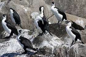
Goose Island provides habitat for seabird species such as black-faced cormorants, little penguins, pied cormorants, pied oystercatchers and sooty oystercatchers. Crested terns and silver gulls also inhabit and breed on the island. Reptiles recorded included marbled geckoes, three species of skink, sleepy lizards (Tiliqua rugosa) and tiger snakes (Notechis scutatus). The island is also a haul out area for Australian sea lions. Introduced species such as cat, feral pigeon, goat, house mouse and rabbit have been present in the past and as of 2009, have been either eradicated, reduced or controlled.[3]
Little penguins
Little penguins are also known to breed on Goose Island, and have been seen there since at least 1950.[4]
Alternative names
Some of the islands of the Goose Island group have alternative names. Little Goose Island bears the gazetted name of Cormorant Island[5] while Seal Rocks are also known as The Scarles.[2]
Scotch College
The island is leased by Scotch College and is visited by groups of Year 10 students from the school. Students camp on the island and engage in various aquatic and nature-based activities as part of their outdoor education program. These include sailing, kayaking, studying wildlife, land regeneration, snorkeling through shipwrecks and swimming with sea lions. The island's management is the shared responsibility of the lessee and the Department of Environment, Water and Natural Resources. Management activities include controlling feral animals and the eradication of introduced plant species, most notably African boxthorn.[6]
Protected area status
Goose Island is located within the extent of the Goose Island Conservation Park while the waters surrounding its shores are part of the Goose Island aquatic reserve and the Eastern Spencer Gulf Marine Park.[7][8]
See also
References
- ↑ BirdLife International (2011) Important Bird Areas factsheet: Goose Island (Spencer Gulf). Downloaded from http://www.birdlife.org on 27/06/2011
- 1 2 Goose Island Aquatic Reserve PIRSA, Government of South Australia. Retrieved 2014-01-20.
- 1 2 Management Plan - Althorpe Islands, Goose Island and Troubridge Island Conservation Parks (PDF). Adelaide: Department of Environment & Heritage. 2009. pp. 16, 19, 20 & 23. ISBN 978-1-921466-76-2.
- ↑ "Governor enjoys island holiday visit" The Advertiser, South Australia (1950-01-16). Retrieved 2014-06-25.
- ↑ Property Location Browser V2 Government of South Australia. Accessed 2014-01-20.
- ↑ Scotch College, Goose Island Scotch College, South Australia. Accessed 2014-04-21.
- ↑ "Summary of SA Marine Protected Areas by Type (see 'SA Reserve List' tab)". Australian Government - Department of the Environment. 10 February 2003. Retrieved 5 October 2014.
- ↑ "Eastern Spencer Gulf". Department of Environment, Water and Natural Resources. Retrieved 20 October 2014.
| West coast of Eyre Peninsula |
| ||||||||||||||
|---|---|---|---|---|---|---|---|---|---|---|---|---|---|---|---|
| Spencer Gulf |
| ||||||||||||||
| Investigator Strait | |||||||||||||||
| Kangaroo Island |
| ||||||||||||||
| Gulf St Vincent | |||||||||||||||
| Backstairs Passage | |||||||||||||||
| Encounter Bay and adjoining waters | |||||||||||||||
| South east coast | |||||||||||||||
| Mainland |
| ||||||||||||||
| |||||||||||||||
| Major Townships | |||||||||||
|---|---|---|---|---|---|---|---|---|---|---|---|
| Minor Townships | |||||||||||
| Governance |
| ||||||||||
| Coastal features | |||||||||||
| Protected areas |
| ||||||||||
| Islands adjoining the Yorke Peninsula coast | |||||||||||
| Related and uncategorised | |||||||||||
| |||||||||||
Coordinates: 34°27′30″S 137°22′19″E / 34.45833°S 137.37194°E