List of public art in Somerset
| Districts of Somerset Areas shown in yellow are the unitary authorities and those in pink are districts administered by Somerset County Council |
|---|
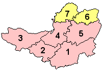 |
| 1 South Somerset |
| 2 Taunton Deane (Borough) |
| 3 West Somerset |
| 4 Sedgemoor |
| 5 Mendip |
| 6 Bath and North East Somerset (Unitary) |
| 7 North Somerset (Unitary) |
This is a list of public art in the Somerset county of England. This list applies only to works of public art on permanent display in an outdoor public space. For example, this does not include artworks in museums.
The ceremonial county of Somerset consists of a non-metropolitan county, administered by Somerset County Council, which is divided into five districts, and two unitary authorities. The districts of Somerset are West Somerset, South Somerset, Taunton Deane, Mendip and Sedgemoor. The two administratively independent unitary authorities, which were established on 1 April 1996 following the breakup of the county of Avon, are North Somerset and Bath and North East Somerset. These unitary authorities include areas that were once part of Somerset before the creation of Avon in 1974.[1]
Public art is art in any media that has been planned and executed with the intention of being staged in the physical public domain, usually outside and accessible to all. Public art is significant within the art world, amongst curators, commissioning bodies and practitioners of public art, to whom it signifies a working practice of site specificity, community involvement and collaboration. Public art may include any art which is exhibited in a public space including publicly accessible buildings, but often it is not that simple. Rather, the relationship between the content and audience, what the art is saying and to whom, is just as important if not more important than its physical location.[2]
Bath and North East Somerset
Bath and North East Somerset (commonly referred to as BANES or B&NES) is a unitary authority created on 1 April 1996, following the abolition of the County of Avon.[3] Bath and North East Somerset occupies an area of 220 square miles (570 km2), two-thirds of which is green belt.[4] BANES stretches from the outskirts of Bristol, south into the Mendip Hills and east to the southern Cotswold Hills and Wiltshire border.[4] The city of Bath is the principal settlement in the district, but BANES also covers Keynsham, Midsomer Norton, Radstock and the Chew Valley. BANES has a population of 170,000, about half of whom live in Bath, making it 12 times more densely populated than the rest of the district.[4]


Mendip
Mendip is a local government district which covers a largely rural area of 285 square miles (738 km2)[13] ranging from the Mendip Hills through on to the Somerset Levels. It has a population of approximately 11,000.[13] The administrative centre of the district is Shepton Mallet.
| Image | Title / subject | Location and coordinates |
Date | Artist / designer | Type | Material | Dimensions | Designation | Owner / administrator | Wikidata | Notes |
|---|---|---|---|---|---|---|---|---|---|---|---|
 |
Adam and Eve | Bishop's Palace, Wells 51°12′33″N 2°38′32″W / 51.209111°N 2.642105°W |
E. J. Clack[14] | Wood | |||||||
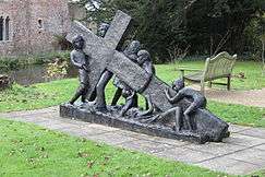 |
The Weight of Our Sins | Bishop's Palace, Wells 51°12′33″N 2°38′32″W / 51.209111°N 2.642105°W |
2010[15] | Josefina de Vasconcellos | |||||||
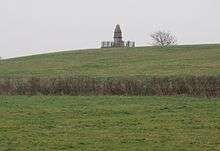
 |
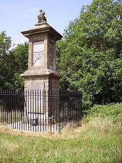
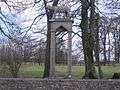
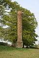
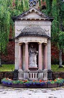
Admiral Hood Monument | Compton Dundon 51°06′05″N 2°43′17″W / 51.101356°N 2.721306°W |
1831 | Henry Goodridge | Tuscan column | Ashlar | 110 feet (33.5 m) high | Grade II* listed building | Q4683688 | ||
 |
Romulus and Remus | 51°14′20″N 2°37′00″W / 51.2390°N 2.6166°W |
1945 | Bonded cast concrete | Created by Gaetano Celestra an Italian prisoner of war at a nearby camp.[16][17] | ||||||
 |
Celebration | Site of West Mendip Hospital, Horrington 51°09′32″N 2°42′02″W / 51.1589°N 2.7006°W |
2005 | James Blunt |
North Somerset
North Somerset is a unitary authority which is administered independently of the non-metropolitan county of Somerset.[18] Its administrative headquarters are located in the town hall of Weston-super-Mare, and has a resident population of 193,000 living in 85,000 households.[19]
| Image | Title / subject | Location and coordinates |
Date | Artist / designer | Type | Material | Dimensions | Designation | Owner / administrator | Wikidata | Notes |
|---|---|---|---|---|---|---|---|---|---|---|---|
| More images |
Silica | Big Lamp Junction, Weston-super-Mare 51°20′50″N 2°58′34″W / 51.3471°N 2.9761°W |
2006 | Wolfgang Buttress | 4 metres (13 ft) wide at the base. 30 metres (98 ft) high.[20][21] | North Somerset Council | Lit by LEDs at night[22] | ||||
.jpg) More images |
The Glassblower | Nailsea 51°26′03″N 2°45′14″W / 51.4342°N 2.7540°W |
2008[23] | Vanessa Marston | Bronze | Nailsea Town Council | |||||
 |
Seafarer's Memorial | Portishead 51°29′41″N 2°46′24″W / 51.4947°N 2.7733°W |
2005 | Stone | |||||||
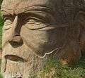 |
Carved head | Leigh Woods 51°26′47″N 2°39′18″W / 51.4464°N 2.6549°W |
Stone | ||||||||
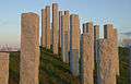 |
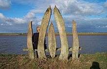
Full Fathom Five | Portishead 51°29′29″N 2°45′15″W / 51.4915°N 2.7543°W |
Michael Dan Archer | Stone | 108 granite columns[24] |
Sedgemoor
Sedgemoor district is a low-lying area of land close to sea level between the Quantock and Mendip hills, historically largely marsh (or moor). It contains the bulk of the area also known as the Somerset Levels, including Europe's oldest known engineered roadway, the Sweet Track.[25]
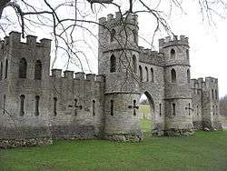
.jpg)

South Somerset
The South Somerset district occupies an area of 370 square miles (958 km2),[32] stretching from its borders with Devon and Dorset to the edge of the Somerset Levels. The district has a population of about 158,000,[33] and has Yeovil as its administrative centre.
| Image | Title / subject | Location and coordinates |
Date | Artist / designer | Type | Material | Dimensions | Designation | Owner / administrator | Wikidata | Notes |
|---|---|---|---|---|---|---|---|---|---|---|---|
 |
Industria Virtute Et Labore | Yeovil | |||||||||
 More images |
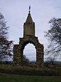
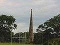
Burton Pynsent Monument | Curry Rivel 51°01′18″N 2°53′21″W / 51.021667°N 2.889167°W |
1767 | Capability Brown | Portland Stone | 140 feet (43 m) high | Grade I listed building[34] | Q5000900 | |||
 |
Dillington House | ||||||||||
 More images |
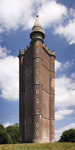
King Alfred's Tower | Brewham 51°06′54″N 2°21′54″W / 51.115°N 2.365°W |
1769-1772 | 49 metres (161 ft) high | Grade I listed building | Q7884143 | |||||
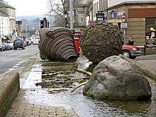 |
Ball and Whirl | Fore Street, Chard 50°52′22″N 2°57′49″W / 50.8728°N 2.9635°W |
1991 | Neville Gabie | Bronze | ||||||
 |
Jack The Treacle Eater | Barwick 50°55′32″N 2°37′23″W / 50.9256°N 2.6231°W |
c. 1920s | Stone | South Somerset District Council | ||||||
 |
Fish Tower | Barwick 50°55′49″N 2°37′38″W / 50.9304°N 2.6273°W |
c. 1920s | South Somerset District Council | |||||||
 |
Cone | Barwick 50°55′26″N 2°37′56″W / 50.9238°N 2.6321°W |
c. 1920s | 75 feet (23 m) high | South Somerset District Council |
|
Taunton Deane
Taunton Deane has borough status. The district of Taunton Deane covers a population of approximately 100,000[35] in an area of 462 square kilometres (178 sq mi).[36] It is centered on the town of Taunton, where around 60,000 of the population live[35] and the council are based, and includes surrounding suburbs and villages.
| Image | Title / subject | Location and coordinates |
Date | Artist / designer | Type | Material | Dimensions | Designation | Owner / administrator | Wikidata | Notes |
|---|---|---|---|---|---|---|---|---|---|---|---|
 More images |
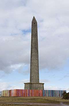
Wellington Monument | Blackdown Hills 50°56′53″N 3°13′45″W / 50.9480°N 3.2293°W |
1854 | Thomas Lee | Triangular tower | Calcareous Grit | 80 feet (24 m) wide at the base and 53.34 metres (175.0 ft) high. | Grade II* listed building | Q7981443 | ||
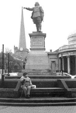
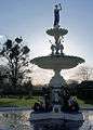 |
Queen Victoria Memorial Fountain | Vivary Park, Taunton 51°00′27″N 3°05′47″W / 51.0074°N 3.0964°W |
1907 | Made by the Saracen Foundry of Glasgow.[37] |
West Somerset
The West Somerset local government district covers a largely rural area, including parts of Exmoor, with a population, according to the 2001 census, of 35,075[38] in an area of 740 square kilometres (290 sq mi).[39] The largest centres of population are the coastal towns of Minehead and Watchet. The council's administrative headquarters are in the village of Williton.
| Image | Title / subject | Location and coordinates |
Date | Artist / designer | Type | Material | Dimensions | Designation | Owner / administrator | Wikidata | Notes |
|---|---|---|---|---|---|---|---|---|---|---|---|
 |
Queen Anne | Minehead | 1791[40] | Francis Bird | Carrara marble | Grade II* listed building | Moved to current site in 1893.[41] | ||||
 More images |
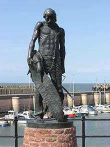
The Ancient Mariner | Watchet 51°10′56″N 3°19′45″W / 51.182084°N 3.329038°W |
2003 | Alan Herriot[42] | 7 feet (2.1 m) high | Watchet Market House Museum Society | |||||
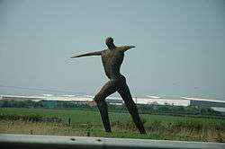
 More images |
The Hand That Holds The Map | Minehead 51°12′36″N 3°28′24″W / 51.2099°N 3.4733°W |
2001 | Owen Cunningham | Steel and welded galvanised iron | 3 metres (9.8 ft) high and 3 metres (9.8 ft) wide[43] | Start of the South West Coast Path | ||||
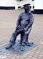 |
John Short[44] | Watchet 51°10′56″N 3°19′45″W / 51.182084°N 3.329038°W |
2008 | Alan Herriot | Bronze | Watchet Market House Museum Society[45] | |||||
.jpg) |
Memorial to Sir Thomas Dyke Acland | Selworthy 51°13′02″N 3°33′50″W / 51.2172°N 3.5639°W |
Wood | 7 metres (23 ft) high | |||||||
 More images |
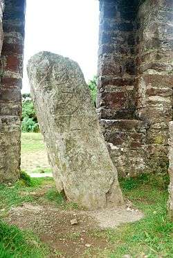
Caratacus Stone | Exmoor 51°05′26″N 3°35′12″W / 51.0905°N 3.5867°W |
Possible 6th century | Stone | Ancient monument | Q1035420 | |||||
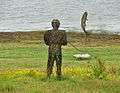 |
Fishing | Wimbleball Lake 51°04′00″N 3°28′00″W / 51.0666°N 3.4666°W |
Wicker |
References
| Wikimedia Commons has media related to Public art in Somerset. |
- ↑ "The Avon (Structural Change) Order 1995". HMSO. Retrieved 9 December 2007.
- ↑ Knight, Cher Krause (2008). Public Art: theory, practice and populism. Oxford: Blackwell Publishing. ISBN 978-1-4051-5559-5.
- ↑ "The Avon (Structural Change) Order 1995". Her Majesty's Stationery Office (HMSO). Retrieved 9 December 2007.
- 1 2 3 "About the area". Bath and North East Somerset Council. Archived from the original on 4 November 2007. Retrieved 30 December 2007.
- ↑ "Monument to Sir Bevil Grenville". Images of England. English Heritage. Retrieved 20 July 2009.
- ↑ "Sir Bevil Grenville's Monument". National Heritage List for England. English Heritage. Retrieved 21 April 2014.
- ↑ Historic England. "Monument to Sir Bevil Grenville at NGR ST 7219 7034 (1214434)". National Heritage List for England. Retrieved 5 April 2015.
- ↑ "Sir Bevil Grenvilles Monument". Pastscape. English Heritage. Retrieved 21 April 2014.
- ↑ "Queen Square obelisk". Images of England. Retrieved 27 August 2015.
- ↑ Ison, Walter (2004). The Georgian Buildings of Bath. Spire Books. p. 129. OCLC 604318205.
- ↑ "Edward VII Memorial". Public Monuments & Sculpture Association. Retrieved 27 August 2015.
- ↑ "Head of Jupiter". Public Monuments and Sculpture Association. Retrieved 27 August 2015.
- 1 2 "A Portrait of Mendip". Mendip District Council. p. 1. Retrieved 19 May 2009.
- ↑ "Bishop's Palace, Wells: Adam and Eve". Victoria County History. Retrieved 27 August 2015.
- ↑ "Don McCullin unveils war sculpture in Wells". BBC. Retrieved 27 August 2015.
- ↑ "A39, statue of Romulus and Remus on land at Beechbarrow House, St Cuthbert Out". Somerset Historic Environment Record. Somerset County Council. Retrieved 27 August 2015.
- ↑ "Romulus and Remus". Public Monuments & Sculpture Association. Retrieved 27 August 2015.
- ↑ "The Avon (Structural Change) Order 1995". Her Majesty's Stationery Office (HMSO). Retrieved 9 December 2007.
- ↑ "Local Area Agreement for North Somerset 2007-2010". North Somerset Partnership. Retrieved 30 December 2007.
- ↑ "Silica". Public Art Online. Retrieved 27 August 2015.
- ↑ "Silica, 2006, Weston-Super-Mare". Wolfgang Buttress. Retrieved 27 August 2015.
- ↑ "Silica artwork". North Somerset Council. Archived from the original on 28 September 2011. Retrieved 2 June 2007.
- ↑ "Damage to glassblower statue reported to police". Western Daily Press. Retrieved 27 August 2015.
- ↑ "Full Fathom Five by Michael Dan Archer". Public Art Portishead. Retrieved 20 November 2016.
- ↑ "The day the Sweet Track was built". New Scientist, 16 June 1990. Retrieved 26 October 2007.
- ↑ Historic England. "Details from listed building database (1205747)". National Heritage List for England.
- ↑ "40ft sculpture unveiled in Somerset". BBC News. 26 September 2000. Retrieved 10 June 2007.
- ↑ "Willow Man – 2001". Serena de la Hey. Retrieved 1 January 2012.
- ↑ "Willow man rises from ashes". BBC News. 19 October 2001. Retrieved 10 June 2007.
- ↑ Adkins, Lesley and Roy (1992). A Field Guide to Somerset Archaeology. Wimborne, Dorset: Dovecote Press. ISBN 0-946159-94-7.
- ↑ "King Alfred's Monument with railings". Images of England. Retrieved 2007-02-09.
- ↑ "An introduction to South Somerset" (PDF). South Somerset District Council. Retrieved 6 June 2012.
- ↑ "Population of South Somerset". South Somerset District Council. Retrieved 11 July 2009.
- ↑ "Burton Pynsent Monument". Images of England. English Heritage. Retrieved 2008-07-05.
- 1 2 "Demographics". Taunton Deane Borough Council. Retrieved 25 April 2009.
- ↑ "Area: Taunton Deane (Local Authority): Key Figures for Physical Environment". Neighbourhood Statistics. Office for National Statistics. Retrieved 25 April 2009.
- ↑ "News from November 2005". West Somerset Railway. November 2005. Retrieved 2008-08-26.
- ↑ "Community and Living". West Somerset Council. Retrieved 23 April 2009.
- ↑ "West Somerset (Local Authority): Key Figures for Physical Environment". Neighbourhood Statistics. Office for National Statistics. Retrieved 23 April 2009.
- ↑ Byford, Enid (1987). Somerset Curiosities. Dovecote Press. p. 45. ISBN 0946159483.
- ↑ "Statue of Queen Anne". Images of England. English Heritage. Retrieved 2 May 2010.
- ↑ "Watchet and Samuel Taylor Coleridge". Market House Museum. Retrieved 27 August 2015.
- ↑ "South Coast Path". Public Monuments& Sculpture Association. Retrieved 27 August 2015.
- ↑ "Yankee Jack". Victoria County History. Retrieved 27 August 2015.
- ↑ "Yankee Jack unveiled". Quantock Online. Retrieved 27 August 2015.
Public art and memorials in the United Kingdom | ||||||||
|---|---|---|---|---|---|---|---|---|
| England |
|  | ||||||
| Scotland | ||||||||
| Wales | ||||||||
| Lists by type | ||||||||
| Organisations | ||||||||
| Projects | ||||||||