List of wards in Bristol by population
.png)
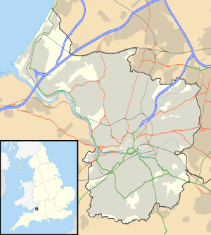
This is a list of council wards in Bristol by population based on the results of the 2011 census. The next United Kingdom census will take place in 2021. In 2011, there were 35 ward subdivisions in Bristol, shown in the table below.
Refer to the Subdivisions of Bristol article in order to understand that a 'built up area' city county such as Bristol has no extensive rural spaces or villages within it's borders, so instead census data population counts are listed for well-defined ward divisions as opposed to less defined neighbourhood areas.
This article is for historical purposes as electoral changes will be made throughout England from 2016, Bristol will ultimately lose one ward and several will be renamed and merged - see the ward table for full details.
List of wards
| Rank | Map of ward | Ward | Population (2011 census)[1] | Neighbourhoods contained within |
|---|---|---|---|---|
| 1 |  |
Lawrence Hill | 18,942 | Barton Hill, St Philips Marsh, Redcliffe, Temple Meads and parts of Easton |
| 2 |  |
Ashley | 16,225 | Baptist Mills, Montpelier, St Andrew's, St Pauls and St Werburghs |
| 3 |  |
Cabot | 15,940 | Spike Island, Baltic Wharf, Redcliffe Hill, Queen Square, Baldwin St, the City Centre, the Old City, Broadmead, Canon's Marsh, Brandon Hill, Park St, Bristol University, Kingsdown, Dove St, the east side of Whiteladies Road, the south side of Cotham Hill and Cotham Brow, and the west side of Stokes Croft |
| 4 |  |
Bishopston | 13,871 | St Bonaventures and Ashley Down parishes, as well as part of Horfield |
| 5 |  |
Easton | 13,541 | Lawrence Hill and Barton Hill estates |
| 6 |  |
Hillfields | 13,504 | Chester Park, Hillfields East, Hillfields North, Hillfields West, Lodge Hill, Mayfield Park, Speedwell, Staple Hill Road South |
| 7 |  |
Windmill Hill | 13,180 | Totterdown and the southern part of Bedminster |
| 8 | 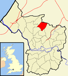 |
Horfield | 12,827 | Monks Park and Southmead Hospital |
| 9 |  |
Cotham | 12,554 | Small portion of Redland |
| 10 | 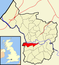 |
Southville | 12,543 | Northern part of Bedminster, Ashton Gate and Bower Ashton |
| 11 |  |
Avonmouth | 12,485 | Shirehampton and the western end of Lawrence Weston |
| 12 |  |
Eastville | 12,455 | Eastville, Crofts End (also known as Clay Hill), Stapleton and part of Fishponds |
| 13 |  |
Bedminster | 12,448 | Southern area of Bedminster, Ashton Vale |
| 14 | 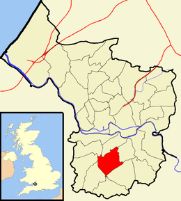 |
Filwood | 12,267 | Filwood Park, Knowle West and Inns Court |
| 15 | 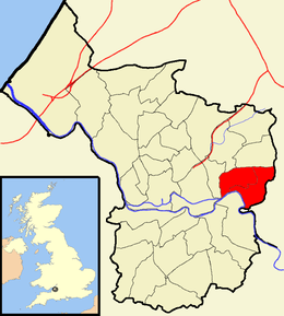 |
St George East | 12,157 | Burchells Green, Crew's Hole, and Two Mile Hill |
| 16 |  |
Lockleaze | 12,080 | |
| 17 | 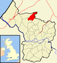 |
Southmead | 11,956 | |
| 18 |  |
St George West | 11,895 | |
| 19 |  |
Redland | 11,801 | Southern part of Bishopston |
| 20 | 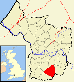 |
Hengrove | 11,723 | |
| 21 |  |
Frome Vale | 11,616 | Broomhill and Fishponds, and also the Glenside and St Matthias campuses of the University of the West of England |
| 22 | 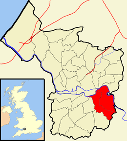 |
Brislington East | 11,584 | Eastern part of Brislington, Broomhill and St Annes Park |
| 23 | 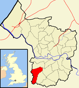 |
Bishopsworth | 11,576 | Bedminster Down, Highridge and Withywood |
| 24 | 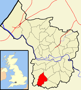 |
Hartcliffe | 11,474 | Headley Park, small portions of Withywood and Bishopsworth |
| 25 | |
Brislington West | 11,355 | Western part of Brislington, Arnos Vale, Kensington Park and St Annes |
| 26 |  |
Knowle | 11,315 | |
| 27 | 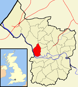 |
Clifton | 11,237 | Cliftonwood and Hotwells |
| 28 | 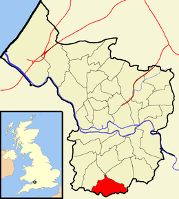 |
Whitchurch Park | 10,839 | Eastern part of Hartcliffe and the western part of Whitchurch |
| 29 | 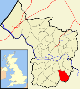 |
Stockwood | 10,802 | |
| 30 |  |
Westbury‐on‐Trym | 10,754 | |
| 31 |  |
Henbury | 10,699 | Brentry |
| 32 |  |
Clifton East | 10,581 | |
| 33 |  |
Henleaze | 10,402 | Golden Hill and Westbury Park |
| 34 |  |
Kingsweston | 10,337 | Coombe Dingle, Lawrence Weston and Sea Mills |
| 35 |  |
Stoke Bishop | 9,269 | Sneyd Park, most of The Downs and a small area of Sea Mills |
| Total | 428,234 |